Warmer Weekend Ahead With An Uncertain Finish

Warmer weather will wash across the Red River Valley this weekend as a south-westerly flow brings in mild Pacific air. While the sun won’t be overly present, conditions will be quite pleasant with mild temperatures and light winds. The weekend will finish on an uncertain note as a Colorado Low ejects from the Central Plains with wavering agreement on where it’s heading after that.

500mb Winds for Sunday Morning

500mb winds valid for Sunday morning at 12Z. A complicated set-up will be underway as the polar jet merges with the sub-tropical jet and a shortwave from the northern Prairies merges into a developing Colorado Low.
Friday

Mostly cloudy.
-6°C / -9°C

Skies will be mainly cloudy today as a warm front pushes eastwards towards the Red River Valley. Temperatures will climb up to –7 or –6°C, a welcome break from the cold temperatures we’ve had over the past week. Winds will pick up out of the south-southeast to 30–40km/h this morning with a slight chance of some local blowing snow through the Red River Valley. There will be a very slight chance of a few flakes of snow but there won’t be anything that can be considered significant. Temperatures will drop a few degrees tonight to about –9°C under mainly cloudy skies.

Saturday

Saturday

A mix of sun & cloud.
-4°C / -9°C

Perhaps the nicest day of the weekend will be Saturday as the clouds begin to break up a little and temperatures climb as high as –4 or –3°C. Winds will remain fairly light through the Red River Valley through the day. Not much to say for Saturday night; skies will likely clear in the evening but fairly quickly cloud over again early in the morning on Sunday.

Sunday

Sunday is a very complicated weather day. As it stands right now, we may see absolutely no snow or…quite a bit of snow, including the potential for a blizzard through portions of the Red River Valley. Temperatures should remain close to what they look to be right now with highs near –5°C across much of the Red River Valley. Winds will likely remain relatively light, regardless of the overall pattern, as there will be no significant Arctic high building into the region.

As for the complicating factors…

Sunday

Mostly cloudy. Snow/freezing rain uncertain.
-5°C / -11°C

The general synoptic pattern will be as such: a significant Colorado Low will be ejecting into central Nebraska on Saturday night with a sharp trough digging northeastwards into SE South Dakota while, at the same time, a relatively weak low pressure system slides south-eastwards out of northern Saskatchewan towards central Manitoba. By Sunday morning, the Canadian low and it’s associated jet stream will merge with the Colorado Low with the CO low situated in central Nebraska with a sharp trough extending northwards through extreme western Minnesota then arcing through the Red River Valley northwestwards towards The Pas, MB. It’s always a concerning issue when the troughs end up west of the Red River Valley, as it can often mean a northward progression of the weather into our area.

Models have notorious struggles with complicated setups where two distinct atmospheric streams merge. It’s an incredibly dynamic, sensitive process in which even small changes can dramatically effect the evolution of the entire system, so models can often waver wildly on what the outcome will be from small changes in their initial conditions. That being said, using ensemble forecasts, the track of the low, and it’s associated snow, has been creeping northwestwards; two days ago the entirety of the snow was forecast to push only into Central Minnesota; now it’s forecast to clip southeastern Manitoba, including Sprague and portions of the Whiteshell. Model trends can sometimes be more helpful than the actual model output, and combining the ensemble’s northwards trend with the knowledge that this is definitely a situation where the model may not tilt the 500mb trough enough and then, as a result, not bring the low far enough north or west, I can’t say with any certainty what Sunday will bring.

There’s a distinct chance that the snow will remain entirely on the US side of the border and we’ll be relatively unaffected by this system. Should things develop in such a way that the low digs a little more and the trough tilts a little more, it’s also entirely possible that another 5–15cm of snow, or potentially higher, will fall across the Red River Valley. In addition to the uncertainty with all these elements, should the precipitation push further to the NW into Southern Manitoba, there will be a distinct potential for freezing rain as 850mb wet bulb temperatures sit on the positive side of the 0°C mark.

The reality is that for this type of setup, it’s simply too early to tell what’s going to happen. We’ll most certainly be providing updates in the comments below on the development of this Colorado Low. For now, it’s safe to assume that Sunday will be a warmer day with winds in the 20–30km/h range, but the actual weather conditions may end up being quite poor depending on the evolution of this system.
Cold Weather Set to Return

We’ll see one (or two) more day of nice weather before things turn cold again, another arctic blast is on the way!

image

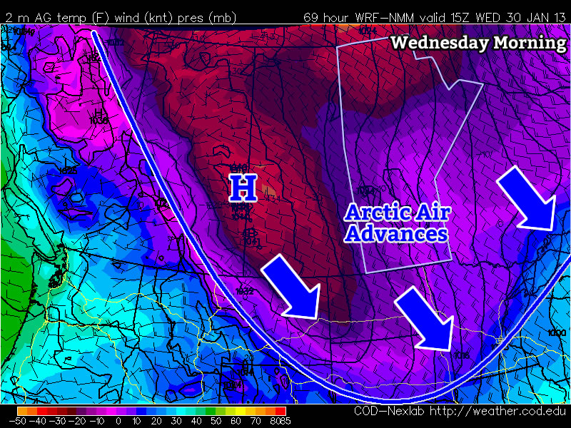
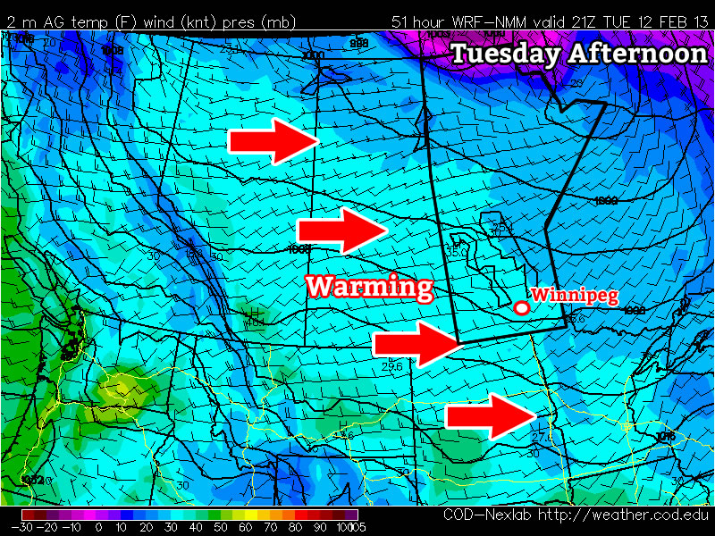
Manitoba will once again find itself right square in the middle of a major trough this week. This will allow another arctic air mass to surge down into Southern Manitoba by mid-week. This frigid air mass will be ushered in by an arctic front on Tuesday, whose arrival will be announced on Tuesday night with increasing north-westerly winds. However, before that happens we’ll see one final warm day on Monday.

Monday

Monday
image
Mainly cloudy. Risk of freezing rain or ice pellets.
-5°C / -12°C

Monday will be the warmest day this week, with high temperatures in the mid minus single digits in Southern Manitoba. There may be some light and sporadic freezing rain or ice pellets in Southern Manitoba on Monday morning. However, colder air aloft will move in later in the morning, turning any lingering precipitation to snow. The wind will be light on Monday, making it a comfortable day.

Tuesday

Tuesday
image
Mainly cloudy. Chance of flurries.
-10°C / -22°C

On Tuesday we’ll transition from early week’s warm weather to the colder weather that is in store for the rest of the week. As the arctic front approaches we may see a few flurries during the day on Tuesday. However, in general Tuesday looks like an OK day, with temperatures remaining slightly above seasonal and winds remaining fairly light. However, that will change Tuesday night as colder air begins spilling in…

Wednesday

Wednesday
image
Mainly sunny
-22°C / -32°C

We return to the deep freeze on Wednesday, with temperatures more or less flat-lining through the day at the morning’s low temperature. Wind chill values will be very cold as well. Wednesday night will be another frigid one, with temperatures expected to drop down around the -30C mark once again.

Models are somewhat ambiguous in terms of the long-range forecast. There is some indication that we may begin to warm up in early February, but there are other indications to suggest we may remain cold. It’s too early to say what is going to happen, so stay tuned for more updates as we go along.

A Break from the Deep Freeze

After enduring a cold end to December, Southern Manitoba is in store for a break from the deep freeze as milder Pacific air works it’s way across the Prairies.

850mb temperatures on Thursday afternoon

850mb temperatures from the GEM-REG model valid on Thursday afternoon. The yellow shaded area denotes warmer (above 0°C) air flooding eastwards across the Praries aloft.

As the low pressure system that brought us light snow overnight slides off into Minnesota, it will drag cooler air into Southern Manitoba behind it. Through the Red River Valley, temperatures will fall to around -13 or -14°C today as colder air from the North slumps southwards. Tonight will see temperatures drop to around -20°C with some cloudy periods and a chance of a light flurry or two.

Milder air will make it’s way into the Red River Valley tomorrow as southwesterly winds pick up to around 30km/h in the morning and begin to scour out the remaining Arctic air. Temperatures will climb up to about -5°C by the evening, marking the start of a stretch of above-normal temperatures. For early January, our normal daytime high in Winnipeg is about -13°C; over the next week, we’ll remain slightly above normal with daytime highs near -9°C punctuated by a day or two where the daytime high climbs back towards the 0°C mark. We’ll likely see plenty of sun over the next week, too, a result of the drier Pacific flow, which will help make the weather quite pleasant.

If you’re wondering where our 2012 Winnipeg temperature summary is, don’t fret! We’ve just been a little busier than expected and are working hard to get it up in the next couple days! Until then, get out there and enjoy the break from the deep freeze.

Pleasant Weekend Ahead

We’ll break out of the deep freeze today as things finally warm up a bit as we head into a mostly snow-free, pleasant weekend.

850mb Temperatures

850mb temperatures for this evening from the GEM-REG model. It’s clearly evident that a substantial area of warm air has pushed northwards over Southern Manitoba.

Yesterday’s 1-3cm of snow that fell across the city marked a shift in the long-wave pattern over the Prairies as the flow shifted from a west to northwest flow to a more southwesterly flow. This has allowed warmer air to flood over Southern Manitoba aloft, and as winds pick up this afternoon, we’ll get a chance to mix it down to the surface.

There will be a slight chance of flurries through the day today, but if they happen they’ll be quite light and very scattered about. Winds will pick up midday to around 20-30km/h, which will help mix down warmer air aloft and warm our temperatures up to around -6°C.

Skies will remain mainly cloudy tonight, and temperatures will remain steady near -6 or -7°C.

Winds will remain out of the south or southwest for most of the day tomorrow, keeping our temperatures around -6°C yet again. By late in the afternoon or tomorrow evening, the winds will shift around slightly to the northwest, which will allow our temperatures to drop to a low of -15°C overnight. We’ll be far from a deep freeze, though, as Sunday looks to bring sunshine back to Southern Manitoba as we climb to a daytime high around a more seasonal -10°C.