Pleasant Weekend Before Big Cool Down

After a dreary evening last night, conditions will gradually improve to quite a pleasant weekend for Winnipeg & the Red River Valley.

The RDPS model is forecasting a line of showers & thunderstorms through the Red River Valley by 5-7PM this evening.
The RDPS model is forecasting a line of showers & thunderstorms through the Red River Valley by 5–7PM this evening.

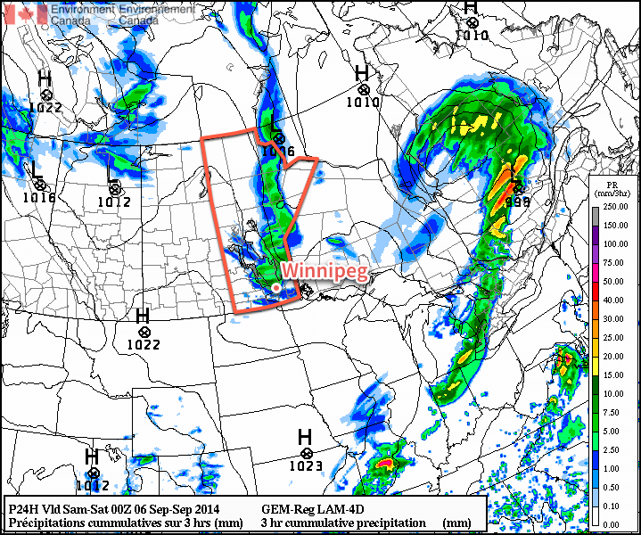
Today will start off with a bit of cloud through the Red River Valley thanks to the Manitoba lakes. We won’t see completely sunny skies, though, as a combination of increasing instability and some cloud moving in ahead of a trough moving across the province produce mixed skies through much of the day.

Friday
18°C / 5°C
Increasing cloud; a chance of showers or thunderstorms in the afternoon.

This afternoon into early this evening will bring a slight chance for showers or thunderstorms across the Red River Valley as that trough line works its way through the region. At this point it doesn’t look like severe weather is likely. Once the trough swings through, northerly winds at around 30km/h will move into the region and general clearing will take place.

Cooler air aloft will once again slump over Southern Manitoba tonight, bringing with it a chance for lake-effect cloud and drizzle once again. Winds, in general, don’t look particularly favourable which will likely limit or exclude their development. Winds will taper off overnight and low temperatures will be near 4 or 5°C.

Improving for the Weekend

Saturday
21°C / 8°C
Cloudy periods

Sunday
23°C / 12°C
A few clouds

Warmer weather will move in for the weekend as multiple low pressure systems draw warmer air eastwards across the Prairies as they move across Central Manitoba. Precipitation is expected to remain through Central & Northern Manitoba, leaving us dry with seasonal highs in the low 20’s. Overnight lows look to dip to around the 10°C mark, give or take a couple degrees.

Big Cool Down Next Week

Unfortunately, the pleasant weather will not be sticking around. Colder air builds into the Northern Prairies behind the systems tracking through during the weekend, which will then be driven southwards early in the week as an Alberta-clipper type system races across the Prairies.

The CPC 6-10 day temperature & precipitation anomaly outlook calls for below normal temperatures and near- to slightly above-normal precipitation.
The CPC 6–10 day temperature & precipitation anomaly outlook calls for below normal temperatures and near- to slightly above-normal precipitation.

850mb temperatures are forecast to drop into the 0°C to –5°C range by mid-week, resulting in daytime highs dropping towards the low teens and overnight lows likely dipping towards the 0°C mark. By mid-week, frost will be a definite concern across Western Manitoba and into the Red River Valley. The big question here in Winnipeg & the RRV will be exactly how much cloud the lakes produce when the cold air slides over them.

At this point it looks like a brief moderate at the end of the week before another cold blast potentially moves through.

Roller Coaster Pattern Setting Up

This week will feature wild swings in the weather. Conditions will range from warm to chilly to snowy, with the weather varying from one day to the next.

A low pressure system will bring light snow to southern Manitoba on Monday

A low pressure system will bring light snow to southern Manitoba on Monday

Monday

Monday

Chance of Snow Late
-10°C / -18°C

Today will be a bit cooler than the conditions we’ve experienced lately. High temperatures will be around the -10°C mark, with southerly winds. We’ll also see some snow begin to move into Western Manitoba from Saskatchewan in the morning or early afternoon. Total accumulations in Western Manitoba are expected to range from 2 to 5cm. The Red River Valley will be right on the edge of this area of snow, so we may end up with a couple centimetres if the snow pushes into the valley.

Tuesday

Tuesday

Decreasing Cloudiness
-11°C / -25°C

Tuesday will remain on the cooler side, though temperatures will remain near or slightly above normal. Highs will once again be near -10C, with a breezy north-west wind, but no precipitation is expected. We’ll cool down into the minus twenties on Tuesday night, but those cold temperatures will be short-lived.

Wednesday

Wednesday

Mainly cloudy. Chance of Flurries. Risk of Freezing Rain or Ice Pellets.
2°C / -18°C

By Wednesday a powerful low pressure system will send warm air cascading across the Prairies. The cold air from Wednesday morning will be scoured out from Southern Manitoba by the afternoon as temperatures rise above zero in most areas. However, this warm air will be accompanied by very strong winds. Southerly winds of 40km/h gusting to 60km/h in the morning will switch to westerly winds of 40-50km/h gusting to 60-70km/h in the afternoon. These warm temperatures should make the snow more difficult to blow around, though some blowing is possible in the morning before we warm up.

Some light snow will be possible on Wednesday in association with this low pressure system. Larger snowfall amounts will be possible if the system tracks further south than currently expected. In addition to the snow, there may even be a bit of freezing rain or ice pellets because that warm air may melt snowflakes as they descend from the clouds. Unfortunately, the cold front associated with this low will pass through on Wednesday night, sending in colder air for Thursday.

Thursday and Beyond

Warmer than normal weather is being forecast by the NAEFS model for the second half of January

Thursday looks to be our coldest day for the next while, with high temperatures near -20C and gusty winds making it feel much cooler. However, besides Thursday It appears we will continue to see temperatures near or slightly above normal for the next while. Long range models continue to suggest that the second half of January will be warmer than normal, though we will still likely see the odd cold day here or there. No major weather systems are in the forecast, but this pattern will probably continue to send a parade of clipper systems coming out of Alberta, bringing the chance for light snow every few days.

Alberta Clipper To Bring Snow and Extreme Cold

Conditions will change dramatically this weekend with no thanks to an Alberta clipper system that will spread snow into Southern Manitoba tonight and usher in extremely cold Arctic air1 to the region on it’s back side. Before that system arrives tonight, however, we’ll get to enjoy a beautiful day with temperatures climbing towards the 0°C mark!

Friday

-2°C / -18°C
Mostly cloudy and warm. Chance of an afternoon flurry. Snow beginning overnight.
Saturday

⇒ -18°C / -32°C
Snow. Windy with blowing snow. Cold.
Sunday

-26°C / -33°C
Mainly sunny. Very cold.

Today will be an exceedingly pleasant day for what has been a markedly cold December. Thanks to a flow of mild Pacific air brought in by westerly winds ahead of the Alberta clipper, we’ll see our temperature climb to around –3 or –2°C today with relatively light winds. Skies will likely remain mostly cloudy through much of the day with the cloud cover being bolstered by the warm temperatures over the snow and a weaker leading impulse tracking through the Interlake. We may see a few breaks in the cloud here or there, particularly through the mid-to-late afternoon period. Unfortunately, that’s where the good news ends. An Alberta clipper is on the way, and it’s a doozy.

Total new snowfall by Saturday evening. Anywhere from 5 to 15cm can be expected along the main frontal zone.

The system will begin spreading snow into the Red River Valley overnight along a line cutting across the northern Red River Valley. The heaviest band of snow will set up along the main frontal zone aloft which will be aligned roughly from Dauphin to Winnipeg and ESE into the Whiteshell. Underneath the heaviest band of snow around 5-10cm of snow can be expected by Saturday morning with amounts tapering to just 2-3cm near the US border. In addition to the snow, a cold front will begin to slump southwards late overnight which will usher in much cooler air. We’ll see temperatures drop to around –18°C with winds shifting out of the north.

Saturday

Saturday will be…miserable. Our temperature will remain steady near around –18°C as cold air continues to infiltrate into Southern Manitoba. Snow will persist through much of the day — although it will likely lighten to just a few flurries by the late afternoon — with another 2–5cm expected to fall across the Red River Valley which will bring storm-total snowfall amounts to around 5cm in areas on the fringes of the system track and anywhere from around 7–15cm under the heaviest band of snow. The winds will become more of an issue on Saturday as they increase out of north to 30–40km/h with gusts as high as 60km/h. These winds, aided by the fresh snowfall, will create areas of poor visibility in blowing snow, especially on any west-east running highways.

Please note: Driving conditions will likely be extremely poor on Saturday morning. In addition to the blowing snow, roads will likely be extremely slippery; the warm temperatures on Friday will likely produce moisture on road surfaces which will rapidly freeze overnight. On Saturday morning, roads will likely be icy with fresh snow on top and blowing snow on top of that. If you need to travel, carry a winter survival kit and give yourself lots of time to reach your destination.

The system will move out on Saturday night bringing clearing skies and extremely cold temperatures as an Arctic airmass settles over the region. Our overnight low will bottom out at about –32°C with fairly light winds.

Sunday

Sunday will be a mainly sunny but very cold day. The temperature will only recover to the low minus 20’s. Winds will remain light — little consolation given the temperatures, though. It’ll drop to around –33°C on Sunday night under clear skies.

When Will It End?

The latest NAEFS 8-14 day temperature outlook is calling for below-normal temperatures for Manitoba.
The latest NAEFS 8–14 day temperature outlook is calling for below-normal temperatures for Manitoba.

Unfortunately, all signs point to the cold weather sticking around for at least the next 4–7 days, if not longer. The NAEFS guidance shows below-normal temperatures expected in the 8–14 day range while all the shorter-range models show cold weather through the next week. The GFS is hinting at a system that might push through late next week that would bring slightly milder temperatures, but it would be short-lived and doesn’t look indicative of a pattern change.

It looks like we’ll definitely be closing out December 2013 as one of the Top 5 coldest Decembers on record in Winnipeg with little reprieve on the horizon. So go enjoy the last nice day of 2013 and then get your long johns ready, plug in the car, get a warm drink, fill up the hot water bottle, renew your CAA membership and whatever else you need to do to prepare for another prolonged bout of extreme cold.


  1. I’m doing my best to not use the phrase “bitterly cold” in today’s blog.  ↩

Santa Delivers A Break From the Deep Freeze

Merry Christmas!

All of us here at A Weather Moment would like to take just a moment to wish you and your families a very Merry Christmas! It’s been a wonderful year here at A Weather Moment and I want to thank you for dropping by — whether this is the first time you’ve ever been to the site or come here regularly — to see what we have to say about the weather. I hope that you find (or continue to find!) what we do here of value and continue to stop by for your weather forecasts, summaries and news!

Holiday Forecast

At the risk of sounding like a broken record that simply utters the phrase “deep freeze” over and over again, I’m glad to let everyone know that we all get perhaps the most wonderful Christmas gift that could be given to us this year: a break from the deep freeze. The next few days will bring temperatures near-then-surpassing our normal temperatures for this year as warmer air floods eastwards across the Prairies.

Christmas Day

-15°C / -25°C
Mixed skies with a chance of afternoon flurries.
Boxing Day

-11°C / ⇒ -10°C
Cloudy periods with seasonal temperatures. Chance of flurries in the morning.
Friday

-4°C / -17°C
Mixed skies and warm. Slight chance of light, isolated flurries.

We’ll see mixed skies today with a daytime high of around –15°C and a chance of some afternoon flurry activity as a weak upper disturbance makes it’s way over our area. No significant accumulations are expected. Winds will be a fairly steady 20km/h or so out of the northwest. We’ll continue to see mixed skies through the overnight period as the temperature drops to around –25°C.

Tomorrow will bring cloudy periods with fairly seasonal temperatures as the mercury climbs to around –11°C. A few flurries are possible in the morning as a weak upper-level warm front pushes eastwards over the Red River Valley. Winds will be fairly light out of the south at only around 15–20km/h. Overcast conditions are expected on Thursday night as a warm front pushes eastwards through the region. Little-to-no precipitation is expected with it as it manages to keep our temperature steady near around –10°C.

Friday will again bring mixed skies, although we do have a chance at becoming mainly sunny for a decent amount of time sometime between the late morning and mid-afternoon period. There’s a slight chance of an isolated flurry or two, but nothing worth going into any detail about. The temperature will climb to a balmy –4°C or so thanks to westerly winds bringing in much milder air.

GDPS precipitation accumluations from Friday evening to Saturday evening show a swath of 10-20cm of snow just north of Winnipeg.
GDPS precipitation accumluations from Friday evening to Saturday evening show a swath of 10–20cm of snow just north of Winnipeg.

Snow will push in overnight as a powerful Alberta Clipper moves into the region. It’s still too early to make any precise predictions, but it appears that the track of the system will bring the heaviest band of snow through the Southern Interlake region with anywhere from 10–20cm of new snow on the ground by the end of Saturday. Amounts drop off to 2–5cm in the Southern Red River Valley. Here in Winnipeg it could end up being a major snowfall; cold air has a tendency to be a bit of a bigger bully than the models let it be and shift storm tracks further south. It wouldn’t take too much shifting for that 10–20cm band to move right over Winnipeg. It’s all too early to tell specifics at the moment, though; it’s fairly likely we’ll see accumulating snow Friday night/Saturday morning, the only question is will it be a little or a lot? We’ll have more details on the system in Friday’s post once things have a chance to develop more.

The Weekend

Things go downhill from there, unfortunately. Another shot of bitterly cold Arctic air[1] will push into the Prairies which will push our daytime highs back into the –20’s and overnight lows to near or below –30°C. Unfortunately, it also looks like it’s going to stick around until at least the middle of next week, if not longer.

So enjoy your Christmas present of a pretty nice 3 days and get out there while you can! From all of us here at A Weather Moment, we wish you and your families a very Merry Christmas and all the best in the coming year!


  1. Have we used this phrase enough to be able to ™ it yet?  ↩