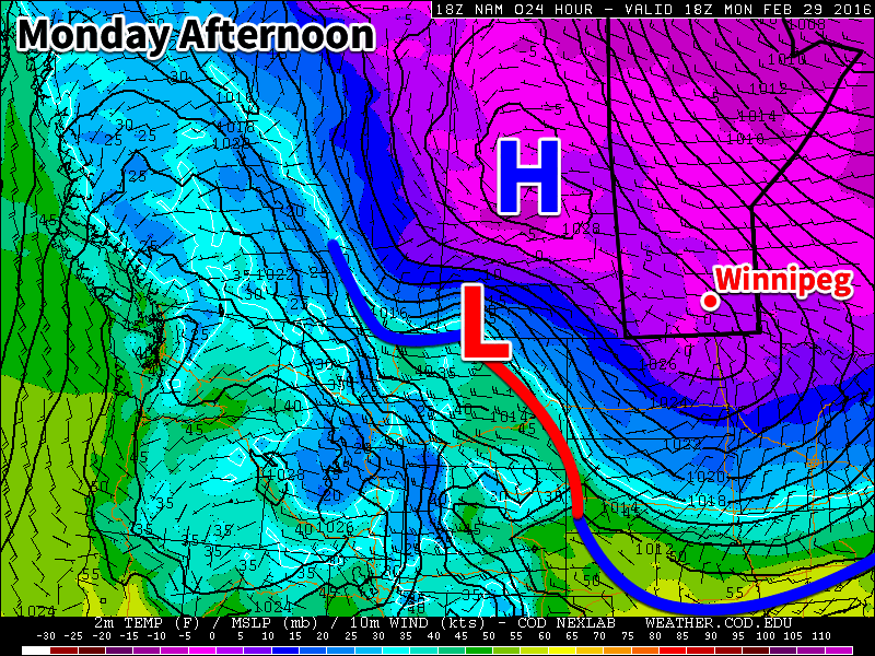
This week will start out with what could be our last arctic outbreak of the winter. Temperatures will remain below seasonal for most of this week, but it appears spring may not be too far away.
Today will be the coldest day of the week, as high temperatures will be stuck in the upper minus teens. An arctic high pressure system sliding down from the north will be responsible for this cold air mass. The outflow from this high will be breezy from the north-west, pushing wind chill values near the -30 mark for much of the day. On the brighter side, it will be sunny, so at least there’s that (pun fully intended by the way)!
An arctic high pressure system will dominate our weather early this week
Tuesday will see slightly warmer temperatures from today as highs climb into the low minus teens. Skies should remain mainly sunny with lighter westerly winds. The arctic high from Monday will still be hovering around the region, preventing warmer air from pushing in.
Wednesday will be much the same as Tuesday, with high temperatures in the low minus teens and mainly sunny skies. Another arctic high will push down from the north and sit off to our north-east. This should bring north-easterly winds to southern Manitoba, with speeds near 20 km/h.
Long Range
The long range forecast suggests that we should begin to see a shift towards above seasonal weather starting in about a week’s time. Models are beginning to strongly indicate that spring-like conditions will build into southern Manitoba sometime around March 5-8 and last into mid-month. Given the time of year, this warm-up should be accompanied by some decent snow-melt. There isn’t much snow to our south and west, so be prepared for a rapid transition to spring once this warmer pattern arrives!
This week will be see temperatures trend below seasonal as a surge of arctic air comes down from the north.
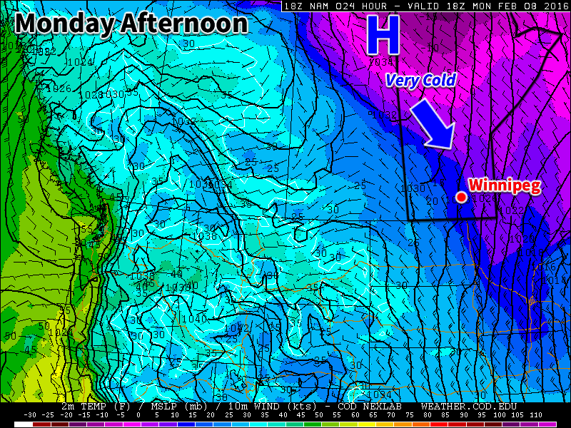
Colder weather is expected this week behind the weekend’s departing low pressure system
Today will be slightly below seasonal as colder air filters southward behind the weekend’s strong low pressure system. High temperatures will be in the low minus teens under clearing skies. Winds will remain stiff out of the north-west at 30km/h gusting to 50km/h. There may still be a bit of drifting snow on the highways with these wind speeds, but heavy blowing snow is not expected.
Tuesday will see a further drop in temperatures as that arctic air mass becomes more entrenched over southern Manitoba. High temperatures will be in the upper minus teens under mainly sunny skies. Winds will remain northerly at about 20km/h. Tuesday night is expected to be quite cold due to the presence of a strong surface ridge of high pressure over the area along with clear skies. Temperatures are expected to drop to around -30C, but luckily wind chill values should not be a significant factor due to the light winds with this high pressure system.
Wednesday will remain cold, with temperatures staying in the upper minus teens. The good part of this colder pattern is that we should continue to see sunny skies on Wednesday. We will be under the centre of a surface high on Wednesday, bringing generally light winds to the region.
Long Range
The long range forecast shows cold conditions sticking around for the rest of the work-week. Models suggest we should warm back up to above-seasonal conditions by the weekend into next week. In the even longer range it appears that we may see one more arctic blast later next week before a more prolonged warm period takes hold towards the end of the month.
Another shot of bitterly cold air is poised to crash through Manitoba this weekend with daytime highs plummeting back into the -20’s and overnight lows dipping close to -30°C.
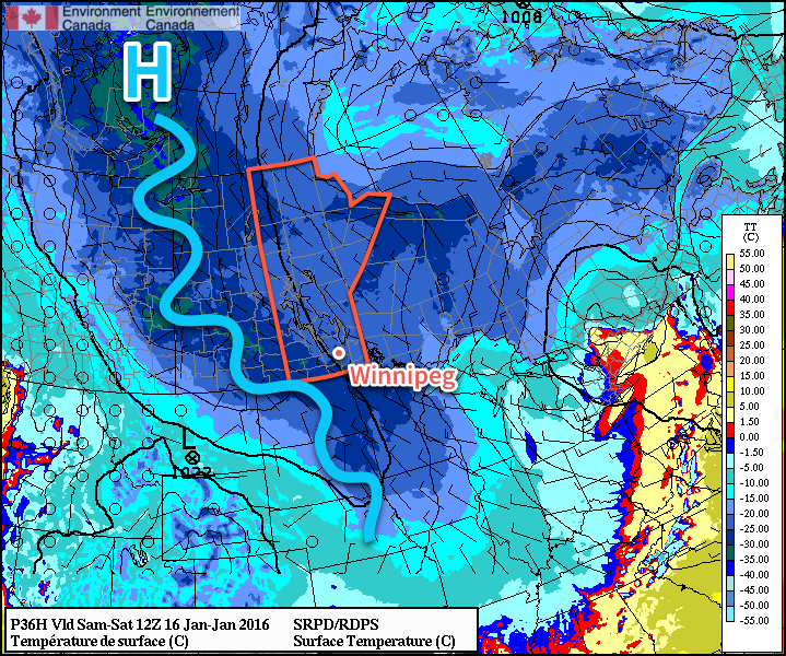
The cold snap this weekend is looking slightly different from earlier in the week and now comes with some good news, some bad news, and a bit more uncertainty. The overall pattern has shifted further west, with the core of the coldest air now forecast to slump southwards over the Saskatchewan/Manitoba border instead of the Red River Valley. This will shift the coldest temperatures westwards, which results in the good news for Winnipeg: it likely won’t be quite as cold as it looked earlier in the week, but just by a couple degrees. The bad news, however, is that there will be a bit more wind throughout the Red River Valley as the light winds in the centre of the ridge shift west with the coldest air.
The RDPS forecast shows very cold temperatures across much of the Prairies on Saturday morning with the main ridge axis running from Northern Alberta through Southern Saskatchewan.
The cold air begins working in today; temperatures will climb to around -19°C today for the daytime high, and then top out between -23 and -21°C on Saturday and Sunday. Overnight lows over the coming days will likely be around -28 or -29°C for the coming 3 nights, depending on "the uncertainty."
The complicating factor with the ridge of high pressure pushing further west will be cloud cover. Two aspects complicate the fair sky forecast:
Uncertainty in how much cloud cover will remain on the east side of the ridge. Many of the Arctic ridges this winter have been "dirty ridges," that is, they are "polluted" by significant amounts of low-level cloud. There are some indications that this may be the case with this next system, but to a much lesser extent compared to others this winter based on satellite imagery of upstream conditions.
Complications with an inverted trough rotating through Central Manitoba. While much of the province will be under the influence of the Arctic ridge, several forecasts show a weak inverted trough associated with a system rotating through Ontario digging into the ridge through Central Manitoba. This feature could produce more cloud that would gradually slump southwards into the Red River Valley.
The biggest uncertainty with cloud cover is Saturday. My best guess at this point is that we’ll see a bit of cloud, however it will overall be a mixed-sky to sunny day. There is an off-chance, though, that we end up mainly cloudy. Cloud cover can marginally impact the daytime high (likely increasing it by around 2°C), and substantially impact overnight lows (keeping them significantly warmer than in clear skies).
That said, with winds likely between 10-20 km/h at night, wind chill values in the -35 to -40 range will be widespread over Southern Manitoba over the coming nights, with -40 or colder wind chills quite likely over southwestern Manitoba. Here in the Red River Valley, -40 wind chills seem unlikely, but could be seen if temperatures get a couple degrees colder than forecast at night or the winds are a tad stronger. Environment Canada issues extreme cold warnings when the wind chill *or* temperature is expected to drop below -40.
Sunday has more confidence in seeing mainly sunny skies.
Long-Range Outlook: Hints of Warming
The first half of the coming week still looks quite cold with daytime highs near -20°C and overnight lows in the -25 to -30°C range. By mid-week, however, it looks like a big change will be on the doorstep.
NAEFS 8-14 day temperature anomaly forecast, valid January 22 – 29, 2016
Current long-range forecast models are beginning to show with higher confidence that the polar vortex will finally be displaced allowing a milder zonal flow to develop. While it doesn’t look like a huge surge of warm air, seasonal to slightly above seasonal temperatures by the end of the week look fairly reasonable.
Right now, the average daytime high is -13°C and the average overnight low is -24°C.
The latest shot of Arctic air is set to be ushered out thanks to an extremely powerful storm north of 60 that will flood the Prairies with mild Pacific air and push our temperatures well above normal by week’s end. The big questions is: will it stick around?
Wednesday
⇓ -27°C / -32°C
Mainly sunny, windy and cold.
Thursday
-10°C / ⇑ -7°C
Increasing cloud with a chance of flurries overnight. Warming.
Friday
-2°C / -17°C
Cloudy and warm. Chance of flurries.
Bitter Cold in Mid-Week Slump
We’ll see bitterly cold temperatures before our big warm-up as yet another very strong Arctic ridge slumps through the province. We’ll see fairly strong winds at around 30km/h gusting to 50km/h out of the northwest this morning and little-to-no recovery from our overnight low today as temperatures struggle to climb before falling to about -27°C this afternoon thanks to the cold air mass that’s pushing in. Blowing snow may remain an issue through the morning hours until the wind begins to taper off. Some cloud cover will linger in the region, but overall it should be a mainly sunny day as it often is when we have these very cold air masses incoming.
Temperatures will drop off to around -32°C or so tonight under clear skies with fairly light winds. Wind chill values will dip to the -37 to -40 range, but it doesn’t look like the criteria for a wind chill warning[1] will be met so I don’t expect any warnings to be issued for Winnipeg.
This forecast tephigram from the NAM shows the sharp low-level inversion in place late Thursday that will likely help produce strong winds.
Thursday will be our transition day, much like (but not quite as strong as) last Wednesday[2], with temperatures warming to around -10°C by day’s end. With such warm air relative to the very cold air that will be entrenched in the valley, a strong inversion will develop which will aid in producing fairly strong winds. They will strengthen as we begin to warm up in the late morning into the afternoon to around 40-50km/h out of the south/southwest. The wind will conspire to make it feel quite a bit cooler than our advertised high would imply, and we may also see localized blowing snow through the valley which could make travel on some roads a little more difficult. A widespread blowing snow event is not expected.
Clouds will roll in through the afternoon as we begin to fall into the influence of the massive storm rolling through the Arctic. There will be a chance of some flurries overnight as our temperature continues to rise to around -7°C although most of the snow activity should stay to our east.
Mild Friday To End Week
Friday will start off on a great foot with temperatures quickly climbing towards -2°C with mixed skies and southwesterly winds at around 30km/h. A weak cold front will push through the Red River Valley midday which will cool off our temperatures slightly, but the bigger impact will the the potential for some snow as the front passes through and then stronger northerly winds in behind it strengthening possibly up to 40km/h with gusts to 50-60km/h. This strong northerly wind will tap into cooler air to our north and dip our temperature from our daytime high of -2°C to around -8 or -9°C by the early evening.
Friday night will bring clear skies as we dip towards -17°C for our overnight low.
Uncertain Weekend Ahead
This 850mb temperature forecast from the GDPS clearly shows the strong baroclinic zone bisecting the Prairies (highlighted).
The weekend is a bit of a wildcard at this point…for the most part. The one thing that’s certain is that we’ll plunge back into the deep freeze by the end of it. After Friday’s cold front, there will be a lull in the progress of the Arctic air as the entire atmosphere pivots with the next shot of cold air pushing in from the high Arctic. As the atmosphere takes this pause, a strong baroclinic zone[3] will develop and align NW/SE through the Prairies. There will be light snow along most of the baroclinic zone as it ripples back and forth with weak impulses, but it’s futile to attempt to pin down exactly where it will lie; models tend to have a lot of difficulty in correctly placing these features.
It does seem like the feature will set up further to our west than the last one and we’ll likely remain east of any snowfall. A disturbance will ripple down the baroclinic zone on Sunday which may bring us some light snow and will usher in the bitterly cold air in behind it.
a. Wind chill values of -40 or lower.
b. Winds greater or equal to 15km/h.
c. Conditions (a) and (b) both being concurrently met for 3 consecutive hours or longer. ↩
…where the temperature rose from -27.1°C in the morning to 3.3°C in the afternoon; a whopping 27.4°C (January 15, 2014). ↩