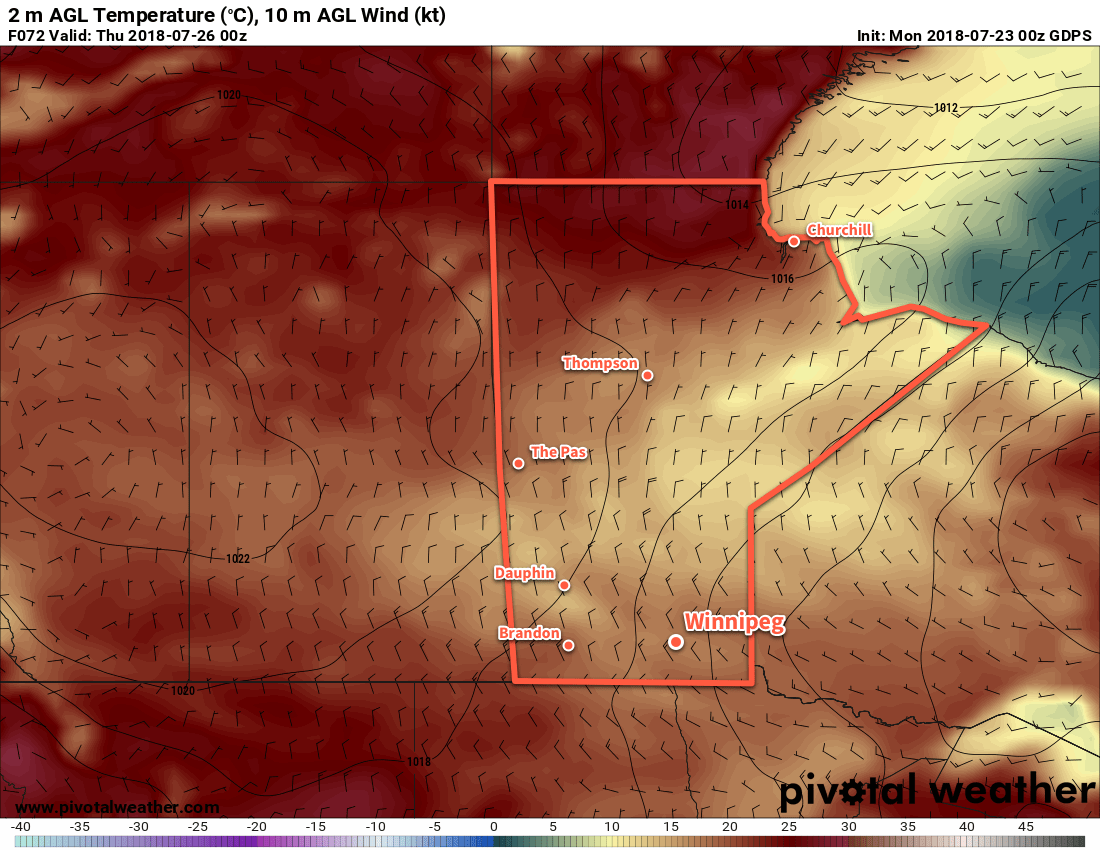
A persistent northwesterly flow aloft will gradually spread below-seasonal temperatures across Manitoba through the first half of the work week.
Southern Manitoba will see a shift into markedly cooler temperatures mid-week as a persistent northwesterly flow draws cooler air from the Arctic southwards. To start the work week, Winnipeg will see plenty of sunshine today with just a few clouds this afternoon. Winds will pick up out of the west to around 20 km/h midday as temperatures climb to a high near 24°C. Winds will ease this evening with temperatures falling to a low near 13°C under clear skies.
Tuesday will bring a bit more cloud to the region as a weak disturbance pushes towards the province from the west. Skies will become mixed in the afternoon with winds strengthening out of the west-northwest to 20 to 30 km/h. Winnipeg will see a seasonal high near 25°C. There’s slight chance of a rain shower in the evening as the disturbance moves through the region. Skies will become cloudy Tuesday night as temperatures head to a low near 12°C.
Significantly below-seasonal temperatures will be in place over southern Manitoba on Wednesday
Decidedly fall-like weather will move into the region on Wednesday. With northwesterly winds increasing to near 30 km/h, Winnipeg will climb to a well below-seasonal high near 18°C. Skies will remain mostly cloudy with a chance of showers through much of the day. The winds will taper off in the evening, but skies will remain fairly cloudy for much of the night. Winnipeg will see a low near 10°C on Wednesday night.
Long Range Outlook
The remainder of the week will bring a return to near-seasonal temperatures with daytime highs rebounding into the mid-twenties. The Red River Valley will see plenty of sunshine with generally dry conditions persisting into the weekend.
Winnipeg’s seasonal daytime high is currently 26°C while the seasonal overnight low is 13°C.
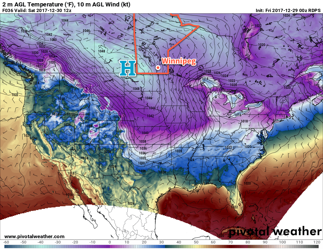
The last few days of 2017 in Winnipeg will see a return to very cold temperatures as another Arctic high slides into the Prairies.
Temperatures are heading right back down into the -20s today as northwesterly winds pick up to around 30 km/h as daytime highs climb to only around -23°C, over 5°C colder than yesterday’s high. The wind will combine with the cold temperatures to produce wind chill values in the -34 to -38 range. Skies will be mixed today before clearing this evening as a potent Arctic high pushes into the province. Temperatures will plummet tonight to a low near -33°C; winds will be relatively light, but at those temperatures barely any wind is needed to produce wind chill values in the -40 to -45 range, so we expect extreme cold warnings will be issued by ECCC later today.
Saturday will be a bone chiller and may end up the coldest day of 2017 as Winnipeg remains entrenched under the Arctic high. With sunny skies and light winds, temperatures will barely recover to a high near -28 or -27°C, and once the sun heads back down, temperatures will return to a low near -33°C.
A potent Arctic high will bring another shot of bitterly cold temperatures to southern Manitoba.
Sunday will see temperatures begin to recover slightly as the Arctic high slumps to the south. Winnipeg will see light westerly winds as temperatures climb to a high near -25°C. Temperatures will remain relatively steady on Sunday night as 2017 comes to a close. The westerly winds will produce wind chill values in the -35 to -40 range, so if you’re going to be outside, make sure you bundle up!
Long Range Outlook
The start of 2018 will continue the trend of below-seasonal conditions, but the worst of the cold will likely be over for the time being. By the end of next week, there’s signs that the cold may finally break and seasonal to above-seasonal temperatures may return to the region with some chances for some light snow.
And that’s it from us for 2017! We’ll be back with a regular forecast on January 1st, followed by some climatological summaries later in the week! Happy new year!
Winnipeg’s seasonal daytime high is currently -13°C while the seasonal overnight low is -23°C.
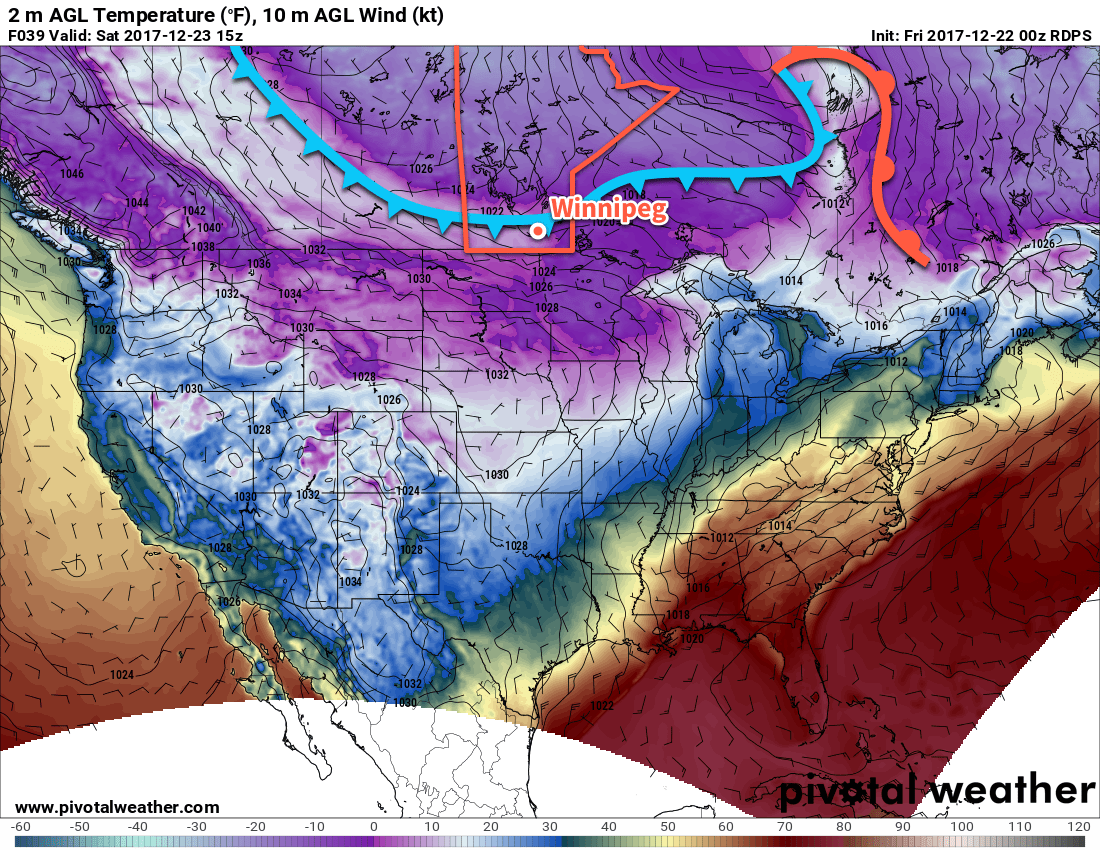
The coldest weather Winnipeg has seen this winter is on the way. A cold front slumping southwards through the province will usher bitterly cold Arctic air into the region and bring Winnipeg its coldest Christmas Day in 20 years.
Winnipeg will see mostly cloudy skies today with the light snow that moved in overnight gradually tapering off as the trough of low pressure creating it moves off to the southeast. Temperatures will rise just slightly to a high near -11°C this morning before cooling slightly behind the trough as winds pick up out of the northwest to 20 to 30 km/h. Clouds will break up tonight as temperatures head to a low near -19°C with light winds.
A cold front will slump through southern Manitoba on Saturday, ushering in much colder air from the north.
Saturday will see that Arctic cold front slowly slump southwards towards Winnipeg. Ahead of it, skies will cloud back over with flurries while temperatures once again climb to a high near -11°C. The cold front will push south of Winnipeg and the Trans-Canada corridor late in the afternoon, gradually clearing out the cloud cover and ushering in the significantly colder air mass. Temperatures will dip down to a low near -26.
Sunday will be the first day of significantly below-seasonal temperatures in Winnipeg as the daytime high barely recovers from the overnight low, reaching just -22°C with light winds. Skies will likely be mixed, but its worth noting that models are struggling to find a consensus on how much cloud will linger behind the cold front. It shouldn’t be cloudier than a mixed sky, but there is a chance that it may end up sunnier than that. Temperatures will then dip to a low near -29°C under mainly clear skies on Sunday night.
Long Range Outlook
The deep freeze locks in for the long haul on Christmas Day, kicking it off with an expected high of only -24°C. This would be the coldest Christmas Day in Winnipeg in 20 years, since the mercury topped out at -27.8°C in 1996.
Top 10 Coldest Christmas Day Highs in Winnipeg, MB
Rank
Daily Max Temp (°C)
Year
1
-30.0
1892
2
-28.9
1933
3
-28.3
1883
4
-27.8
1996
5
-27.4
1990
6/7
-26.7
1917/1882
8
-26.4
2017
9
-26.1
1903
10
-25.6
1934
While this year won’t likely break into the top 10 coldest Christmas Day highs, it won’t be far off. If Winnipeg sees a high of -24.0°C, it would be the 13th coldest high temperature on Christmas Day in Winnipeg’s 145 year climatology.
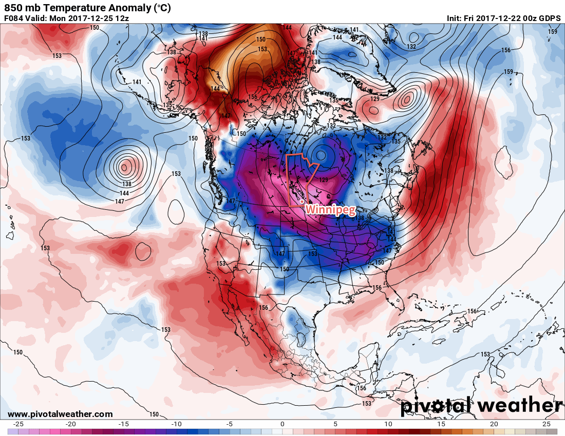
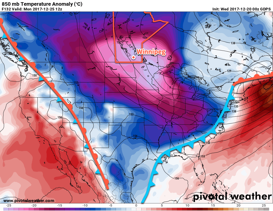
A bitterly cold air mass will be in place over southern Manitoba on Christmas with 850mb temperatures expected to be over 20°C below seasonal values
The cold weather will then remain entrenched over the region for the remainder of the week, with daytime highs in the -20’s and overnight lows near or colder than -30°C.
Bundle up and have a safe and happy holiday! We’ll be taking some time off for Christmas, so there will be no forecast issued on Monday. Depending on how the 12 days of Christmas go, we’ll be back either next Wednesday or Friday with your forecast heading towards the end of 2017! In our absence, we recommend you check out ECCC’s forecasts and monitor for any warnings that may be issued due to the cold.
As ECCC mentioned in the special weather statement issued on Thursday afternoon, extreme cold can be deadly. Even moderate exposure, if not adequately prepared, can leave you with frostbite or hypothermia. If your holiday plans involve travelling on area highways, make sure you bring warm clothes and ensure that you’ve created an emergency car kit in case you encounter unexpected disruptions. Additionally, review the cold weather health information compiled by Manitoba Health for tips on how to recognize danger signs of extreme cold and advice on how to protect yourself and others.
Winnipeg’s seasonal daytime high is currently -11°C while the seasonal overnight low is -22°C.
The Polar Express is on its way to Winnipeg, and we’re not talking about the book. After near- to slightly below-normal temperatures through the latter half of the work week, Arctic air will surge southwards this weekend, sending temperatures towards what may end up the coldest Christmas Day in two decades.
Today will bring mainly cloudy skies to Winnipeg as a low pressure system crosses through the Dakotas, spreading a broad area of cloud ahead of and north of its path. This low will also reinforce light northerly winds over the Red River Valley, tapping into the first of a series of Arctic highs that are slumping southwards out of the north. The cloudy skies and cool wind will result in temperatures a bit below seasonal with a high around -15°C in Winnipeg. No accumulating snow is expected today, either in Winnipeg or south of the city; it should remain south of the American border in the Dakotas.
Skies will clear out overnight as temperatures head to a low near -25°C.
Winnipeg will see light winds and sunny skies on Thursday with temperatures once again climbing to a high near -16°C. A low pressure system moving across the northern Prairies will begin spreading a milder air mass into the region in the evening; skies will cloud over as southerly winds pick up into the 20 to 30 km/h range. Temperatures will climb overnight to around -13°C early Friday morning.
Friday will mark the start of the major transition in temperatures over southern Manitoba. After reaching a high near -10 or -11°C, a cold front will sweep through region bringing a bit of light snow. Northwesterly winds will develop behind the front and temperatures will gradually begin to fall. The one saving grace will a rather extensive patchwork of cloud left in the wake of the cold front, which will prevent things from getting too cold. Temperatures will fall to a low near -20°C with a slight chance of flurries overnight.
Long Range Outlook
Temperatures will plummet across southern Manitoba this weekend as a large-scale pattern change happens, allowing bitterly cold Arctic air to spill southwards across the Prairies.
Forecasts are showing a bitterly cold air mass in place over southern Manitoba on Christmas Day, represented here by 850mb temperatures over 20°C below seasonal values
This bitterly cold air mass will become entrenched over the region, bringing cold daytime highs at or below the seasonal overnight lows for several days on end. Looking towards Christmas Day, it looks like high temperatures will be around -24°C. This would be the coldest Christmas in 20 years, back to 1996 when the daily high was a frigid -27.8°C. No significant improvement in temperatures will occur through the remainder of next week.
Stay warm, Winnipeg!
Winnipeg’s seasonal daytime high is currently -11°C while the seasonal overnight low is -21°C.