A Much Cooler Start to the Week

After last week’s high heat and humidity, the much cooler conditions this week will come as a relief to many. However, it might be a little bit too cool, with temperatures only hovering around 20C.

Today will be cool, but fairly pleasant. Temperatures will be near the 20C mark in southern Manitoba under a mixture of sun and cloud. Winds will be light as a surface ridge of high pressure will be in place over southern Manitoba. Portions of western Manitoba may have a slight chance of a shower, but otherwise no precipitation is expected.

Forecast 500mb Winds with Jetstream Annotation from the RDPS
A deep trough over the Central Prairies will deflect the jet stream well to our south, bringing unseasonably cool weather to most of the Prairies.

Tuesday will see little change in conditions from Monday. High temperatures will remain near 20C, with mainly sunny skies. Winds will be from the north-east at 20km/h.

Wednesday will once again be seasonably cool with temperatures in the low twenties. Skies are expected to be a mixture of sun and cloud with breezy winds out of the north.

Long Range

The long range forecast shows generally seasonable to below seasonable temperatures in southern Manitoba over the next week. However, we may see more surges of warm air as move move toward the end of the month.

Below Normal Weather to Start the Week

This week will start out on the cool side with high temperatures in the low twenties.

Monday

Today will be mainly sunny with temperatures in the low twenties. The average high temperature for early August is 26°C, so this will represent cooler than normal weather. The wind will be north-west at 30km/h.

Tuesday

Tuesday will see much the same weather as Monday, with temperatures in the low twenties. Skies should once again be mainly sunny and winds will be light.

Wednesday

Wednesday may feature showers in southern Manitoba as a low pressure system passes through the region. Accumulations look to be fairly small at this point, so it will not be a significant event. Besides the rain, temperatures will remain below seasonal with highs in the low twenties. Winds will be breezy from the south.

Cool Weekend on Tap

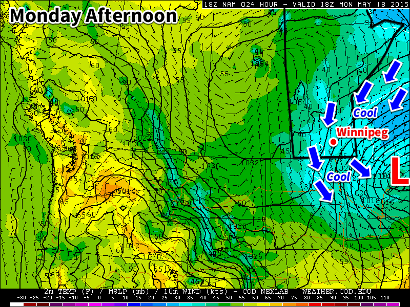
Just when it felt like Winnipeg was out of the woods and summer had arrived, conditions will make it feel like the clock has been turned back to the beginning of the month with temperatures 10°C below normal and a risk of frost returning for the weekend. The cooler weather is courtesy an Arctic airmass that is plunging southwards behind yesterday’s potent system that brought rain & thunderstorms to Saskatchewan & Manitoba.

Today will be a very cool day with brisk northerly winds at 30km/h with some gusts up to around 50km/h.  Today’s high will top out at just 11–12°C through the Red River Valley with mixed-to-cloudy skies until the afternoon when things begin to clear up.  Winds will ease tonight with temperatures plummeting towards the freezing mark. Winnipeg will just be ahead of the main ridge axis, making sub-freezing temperatures quite possible. Areas near the core of the city may escape frost, however anywhere closer to outskirts of the city will have a strong chance of seeing some frost. The low will vary depending where in the city the temperature is measured, but in general I expect it to be around 0°C with temperatures possible 1–2°C colder than than near the outskirts of the city. Rural areas will likely deal with overnight lows of –1 or –2°C.

The remainder of the weekend looks much calmer but still cool. Saturday and Sunday will see high temperatures returning back towards the mid-teens with mainly sunny skies. Some cloud will push through late Saturday through early Sunday which should help keep the overnight lows in the low-to-mid single digits.

A Glance At Next Week

The start of next week will bring a return to more seasonable high temperatures in the 20’s, however alongside the warmer weather comes the potential for more unsettled weather as multiple systems track through the Southern Prairies & Northern Plains.

As such, Southern Manitoba will likely be dealing with a decent chance for showers or rain through the first half of the week. Depending on how things develop, rainfall totals could be anywhere from a trace to over an inch, so we’ll be sure to track things as the weekend progresses. The weather looks to settle down for the second half of the week with daytime highs in the upper teens to lower 20’s.

Chilly Start to the Week

This week will start off on the cool side as a brisk northerly flow builds in behind this weekend’s Colorado Low. Temperatures on Monday will be downright chilly for mid-May.

Cool weather will dominate southern Manitoba on Monday

Monday

We’ll see skies gradually clear today as the system that brought us rain (and snow) this weekend departs. It will remain very chilly though, as temperatures barely climb into positive values. Daytime highs will only make it into the low to mid single digits, which should hopefully be enough to melt a good amount of the snow that fell. Winds will be northerly at 40 km/h gusting to 60 km/h, but will taper off throughout the day as the system pushes further off to the east.

Tuesday

Tuesday will remain on the cool side, but should be a fairly pleasant day (at least relative to the weekend!). High pressure will build into the region behind the weekend’s low pressure system, bringing much calmer conditions. High temperatures will climb into the teens under mainly sunny skies and light winds.

Wednesday

Wednesday will be quite nice as temperatures climb into the upper teens under mainly sunny skies. Winds will be relatively light and from the north-west, making for another pleasant day.

Long Range

The long range forecast shows conditions remaining slightly below normal through the end of the work-week. There are hints that we’ll see warmer conditions build in by the weekend, but it’s too early to say for sure. In general, models show us transitioning to a generally warmer pattern toward the end of the month, although there will still be some cooler days mixed in here and there.