This week will start off on the cool side as a brisk northerly flow builds in behind this weekend’s Colorado Low. Temperatures on Monday will be downright chilly for mid-May.
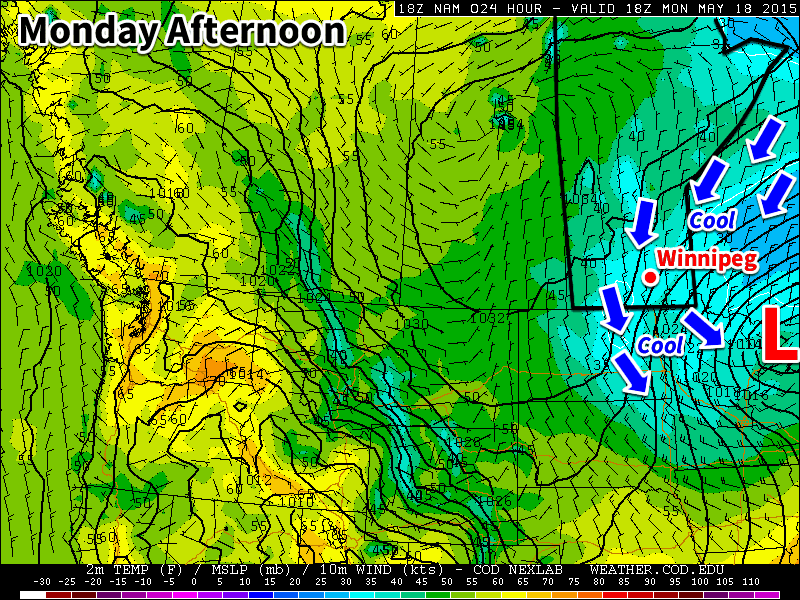
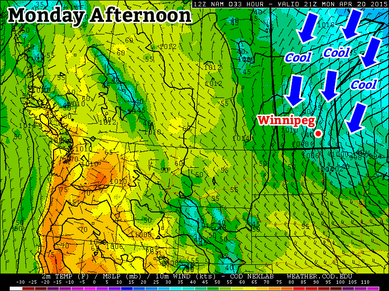
Cool weather will dominate southern Manitoba on Monday
Monday
We’ll see skies gradually clear today as the system that brought us rain (and snow) this weekend departs. It will remain very chilly though, as temperatures barely climb into positive values. Daytime highs will only make it into the low to mid single digits, which should hopefully be enough to melt a good amount of the snow that fell. Winds will be northerly at 40 km/h gusting to 60 km/h, but will taper off throughout the day as the system pushes further off to the east.
Tuesday
Tuesday will remain on the cool side, but should be a fairly pleasant day (at least relative to the weekend!). High pressure will build into the region behind the weekend’s low pressure system, bringing much calmer conditions. High temperatures will climb into the teens under mainly sunny skies and light winds.
Wednesday
Wednesday will be quite nice as temperatures climb into the upper teens under mainly sunny skies. Winds will be relatively light and from the north-west, making for another pleasant day.
Long Range
The long range forecast shows conditions remaining slightly below normal through the end of the work-week. There are hints that we’ll see warmer conditions build in by the weekend, but it’s too early to say for sure. In general, models show us transitioning to a generally warmer pattern toward the end of the month, although there will still be some cooler days mixed in here and there.
Temperatures will remain well below normal through the coming weekend as unseasonably cool air becomes entrenched over the region behind the Colorado Low that brought rain to Southern Manitoba on Wednesday & Thursday.
Today will be a comparatively chilly day with temperatures struggling to climb to a high of just 7°C; this is around 10°C below the average high of 18°C for this time of year. The cool temperatures will be accompanied by gusty northwesterly winds of 30km/h with gusts to about 50km/h throughout most of the day. Skies will be fairly cloudy, but a few sunny breaks will manage to materialize through the day.
Tonight in the Red River Valley will bring cloudy periods and a low temperature dipping just below freezing to –1°C.
Saturday and Sunday will be fairly similar days with highs near 11 or 12°C and mixed skies as some cloud cover streams across the region from North Dakota. Winds will be relatively light out of the north at around 20km/h. Both Saturday and Sunday night will bring some cloud with lows in the 1–3°C range.
Cool Weather Persists Into Next Week
There’s nothing but bad news for those hoping for a quick rebound back to summer-like weather: it’s going to take quite a while for seasonal temperatures to return to the Red River Valley.
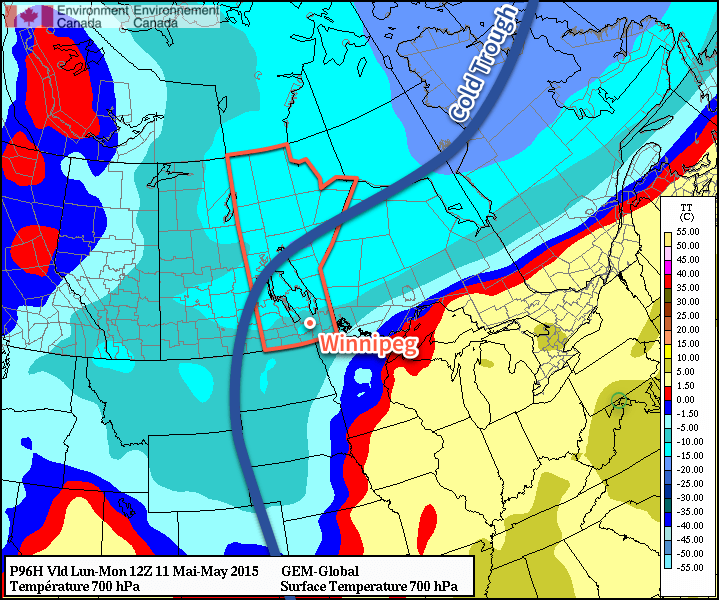
This image valid Monday morning from the GDPS shows a trough of cold air remaining entrenched over Manitoba. Image depicts 700mb temperatures.
Cooler-than-seasonal temperatures are expected to persist until the middle of next week thanks to the cold trough pictured above remaining stubbornly entrenched over the province. Long-range models are showing a return to seasonal warmth in the high teens for the second half of next week as an upper-level ride begins to build into the region, shunting the colder weather off to the east.
Temperatures will be stuck well below-normal for late April through the remainder of the week as a stationary long-wave trough locks Manitoba into a pool of cold Arctic air. To make lemonade of it, skies will at least be quite sunny and winds light making things comparatively pleasant to how the week started.
The next two days will be very similar and very quiet weather-wise. Both today and tomorrow will bring mainly sunny skies, light winds and high temperatures near +5°C. Tonight will be another brisk evening with a low near –7°C while tomorrow night will bring slightly warmer temperatures with a low near –3°C. All of these temperatures are well below normal, though. Daytime highs will be about 8°C below normal[1], a far cry from the 10–15°C above normal we saw last week, and overnight lows will be 4–8°C below normal.[2]
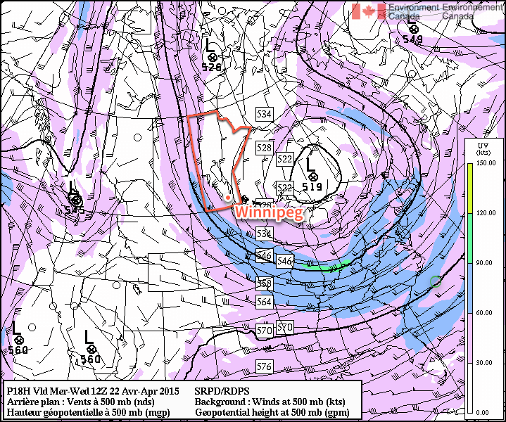
The 500mb wind pattern Wednesday morning shows a highly amplified ridge over Alberta & the Western Arctic diving into a very deep trough over Manitoba & Ontario.
By Friday, the stagnant ridge-trough pattern that has set up over North America will begin to break down. Throughout the day, Southern Manitoba will increasingly come under the influence of a trough of low pressure stretching from a low tracking through South Dakota to a low lifting through Alberta. Out ahead of the South Dakota low, it’s likely that some flurries will develop along the US border in southwestern Manitoba and spread east along border regions through the day. At this point, it looks highly probable that any flurry activity will remain south of Winnipeg. That being said, Winnipeg will see increasing cloud cover and a fairly cool high of just 4°C. Clouds should clear out Friday night with a low near –4°C.
Long Range: A Shift To a Wetter Pattern?
The long range forecast is a little tricky at this point, however we can break it down into two categories of uncertainty: timing and weather pattern. The second there’s a fair amount of confidence in; the timing, however, is a lot more difficult. The current long-wave weather pattern over North America is known as a blocking pattern. These weather patterns are very stable configurations of the jet stream and other upper-level features that result in stagnant weather patterns; these can be stretches of hot, dry weather in the summer[3] or long periods of well below-seasonal temperatures.[4]
Weather models are quite good at forecast what sort of weather pattern may develop when the blocking pattern breaks down, however they are generally quite poor at the actual timing of the break-down. This is because to shift these very stable features, significant changes in the long-wave pattern have to develop across huge distances, and those changes can be very difficult to forecast accurately.
That being said, we should start to see our current weather pattern break down this weekend, driven by an approaching low that will drive a wedge into the elongated upper ridge over the west coast as well as the retrogression of an upper-level low[5] from Ontario. As this happens, cool weather will blanket much of the Prairies – although it won’t likely be any cooler than we’re seeing now – and it looks like there will be an increased chance of precipitation through the Southern Prairies, perhaps even multiple low pressure systems coming through.
All to say it’s going to go from cool and dry to cool and, quite likely, unsettled through the coming weekend. Looking even further ahead, it does look like next week we’ll see a return to seasonal temperatures.
Normal daytime highs for late-April in Winnipeg are around 13°C. ↩
Normal overnight lows for late-April in Winnipeg are around 0°C. ↩
This happens when an area gets stuck underneath a cold trough; this is what’s happening over Manitoba right now. ↩
A low pressure system “retrogrades” when it’s motion becomes opposite that of the usual motion; in our case, it’s when a low moves from east to west instead of west to east. ↩
This week’s weather will be significantly cooler than what we experienced last week as a upper-level system to our east pulls down chillier air from the north.
Cool weather will prevail on Monday under a stiff northerly flow
Monday
Today will be cool, cloudy, and precipitation-y. We’ll see some mixed showers and flurries throughout the day as a strong low pressure system exits our region. High temperatures will be in the mid single digits, meaning that even if it does snow it won’t stick around for long. Winds will be gusty due to the departure of that weather system, with values from the northwest of 40km/h gusting to 60km/h.
Tuesday
Tuesday will remain cool and breezy, but we will see some sun! High temperatures will be in the upper single digits under mainly sunny skies. Winds will be northerly at 20-30 km/h, making it feel on the chilly side.
Wednesday
Wednesday will be slightly cooler than Tuesday as more cool air pours in from the north. High temperatures will be in the mid to upper single digits, but skies will remain mainly sunny. Winds will be northerly at 20-30km/h once again
Long Range
The long range forecast suggests that this cooler pattern will stick around for at least the rest of the week. A persistent trough is expected to remain parked just to our east, meaning that cool air will be continually pumped into southern Manitoba during the short to medium-term. However, in the longer range this pattern is expected to break-down, ushering in a return of more seasonal conditions.