Warmer Weather Returns Quickly to Winnipeg

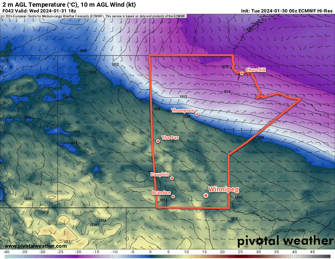
It’s a cold start to the day in Winnipeg, but the first cold night marks the end of this cold snap; warmer weather is surging back across the Prairies.

RDPS 2m Temperature Forecast valid 21Z Saturday February 17, 2024
Warmer weather will spread across southern Manitoba on Saturday.

The cold weather this morning will break quickly as westerly winds move into the region with a warm front pushing through. Temperatures will warm from the mid-minus 20s this morning to an afternoon high near -10 °C. Westerly winds will pick up through the day to around 30 km/h in Winnipeg. The sun will make an appearance this morning, but skies will cloud over through the day.

The winds will continue through the night with temperatures near -10 °C. There will be a chance of flurries overnight.

Saturday will bring cloudy skies to Winnipeg with a few sunny breaks possible in the afternoon. Behind the warm front, daytime highs will climb into the -5 to 0 °C range with breezy westerly winds up to 40 km/h.   Temperatures will then dip to a low near -10 °C under partly cloudy skies on Saturday night.

Light northerly winds will continue on Sunday with a cooler high than Saturday, topping out near -5 °C in the afternoon. Winnipeg should see plenty of sunshine, though, which will be a nice change from the recent warmth. It will be another cool night on Sunday night as a cold front slumps through southern Manitoba. Overnight lows will likely dip into the -20 to -15 °C range with mainly clear skies.

Long Range Outlook

An upper ridge will continue to build across the Prairies next week, keeping temperatures near to slightly above-normal through the first half of the week. A cold front will begin to slump southwards mid-week, bringing a chance of snow to the region followed by cooler temperatures to end the week.

The pattern after that is uncertain, but it looks like the region could be in for near-seasonal temperatures with more frequent chances for snow heading through the weekend and into next week.

Today’s seasonal daytime high in Winnipeg is -8 °C while the seasonal overnight low is -18 °C.

Mild Week Ahead for Winnipeg

Temperatures will stay well above normal values this week as mild Pacific air continues to wash over southern Manitoba.

ECMWF 2m Temperature Forecast valid 18Z Wednesday January 31, 2024
Mild Pacific air will bring above-seasonal temperatures to most of the Canadian Prairies this week.

Persistent upper ridging over western Canada will keep a steady stream of milder air from the Pacific flowing over the region this week. As a result, daytime highs in the mid-single digits will persist through the week, while overnight lows dip to, or a few degrees below, freezing.

Winnipeg will see variable cloudiness over the coming days, trending cloudier in the second half of the week. Breezy southerly winds will develop over the region today, but winds will then ease for the next couple days.

Notable with this warmth, Winnipeg will likely see dew point temperatures climb above freezing in the days ahead. This will help make a significant dent in the snow pack over the region; when dew point temperatures climb above freezing, the warmth can dramatically increase the amount of melt that can occur. As a result, not only will the snow situation across the city look different at the end of the week, fog will be a likely sight overnight and in the early mornings through the course of the week.

Long Range Outlook

Cloudier weather will move in for the weekend, but with that will come more warm weather with overnight lows that could even stay above freezing.

The warm weather will continue into next week.

Today’s seasonal daytime high in Winnipeg is -11 °C while the seasonal overnight low is -22 °C.

Colder Weather Finally on the Way for Winnipeg

A series of cold fronts will slump through Manitoba this week, gradually bringing colder weather into the region. Along with a chance of flurries, Winnipeg could see its first encounter with colder winter temperatures of the season by the coming weekend.

RDPS 2m Temperature Forecast valid 21Z Thursday January 4, 2023
By the second half of the week, much colder air with temperatures below -30 °C will begin to build into northern Manitoba.

Tuesday will start with northwest winds near 20 km/h through the Red River Valley and increasing cloudiness as a cold front slump into the region. A chance of flurries will develop for the afternoon in Winnipeg, but no more than a centimetre or two (at most) is likely. Temperatures will climb to a high near -4 °C — a tad cooler than yesterday — and then dip to a low in the -15 to -20 °C range tonight as the clouds break up. The chance for flurries will extend into the evening before tapering off.

An area of high pressure will move through southern Manitoba on Wednesday, bringing partly cloudy skies and a high near -10 °C. Temperatures will dip back into the -15 to -20 °C range on Wednesday night with increasing cloudiness overnight.

On Thursday, a low pressure system crossing the province will drag milder air back into the Red River Valley. With cloudy skies, daytime highs will climb back into the -5 to -10 °C range along with southerly winds up to 30 gusting 50 km/h. Skies will stay mostly cloudy on Thursday night as a cold front slumps southwards; overnight lows will dip into the -10 to -15 °C range.

Long Range Outlook

The first work week of 2024 will end with cloudier skies and a high again in the -5 to -10 °C range. That will mark the last of the seasonably mild weather, though, as a major pattern change ushers in a colder weather pattern.

Heading into the weekend, multiple large-scale feature interactions will begin to draw the Polar Vortex westwards from the Baffin Island area. By early next week, it will sit over southern Nunavut, and is forecast to then drop into Manitoba through next week.

As this happens, significant amounts of cold air will begin to develop over the southern Arctic and northern Prairies. This will likely result in daytime highs in the mid-minus teens in much of southern Manitoba with temperatures dropping into the -30’s over northern Manitoba.

Heading into next week, the cold air will continue to build to the north, and likely surge southeastwards sometime mid- to late-week. This could bring daytime highs down into the -20s with overnight lows potentially dipping to -30 °C.

Of note, this entire transition is forecast to occur with little to no snowfall.

Enjoy the last of the milder weather; it looks like harsher winter temperatures will be here in the near future.

Today’s seasonal daytime high in Winnipeg is -13 °C while the seasonal overnight low is -23 °C.

More Dry and Mild Weather Ahead for Winnipeg

With the Polar Vortex well north of its usual end-of-year resting spot, Winnipeg’s mild winter will keep on keepin’ on.

RDPS 2m Temperature Forecast valid 06Z Monday January 1, 2024
Temperatures will dip down into the minus teens to ring in 2024.

That “deep winter” that Winnipeg so often sees settle into the region by the end of the year will be missing in action this year. Over the next few days, upper ridging building in from the west will continue to bathe the region in comparatively mild temperatures. A few weak disturbances will bring bouts of cooler temperatures, but temperatures will stay above-normal across the region.

There may be fog to start the day, but otherwise it will be mainly sunny with a high near freezing. Winds will pick up out of the northwest to around 20 km/h this afternoon, then strengthen overnight closer to 30 km/h. Skies will cloud over tonight as a weak low pressure system approaches. Expect a low in the -5 to -10 °C range.

Saturday will start with cloudy skies and a chance of flurries as a low centre collapses over southern Manitoba. As its frontal wave drops southwards, flurries will be possible across Southern Manitoba. The flurries will taper off in the afternoon with a high near -5 °C. Winds will hover in the 30 gusting 50 km/h range for the day, then begin to ease in the evening. Winnipeg should see partly cloudy skies with a low dipping into the -10 to -15 °C range as cooler air slumps into the region.

A ridge of high pressure should bring sunshine back to the region on Sunday with a high in the -5 to -10 °C range. Winds will be light. Temperatures will again dip back into the -10 to -15 °C for New Year’s Eve night with a southerly wind picking up to 20 km/h.

Long Range Outlook

2024 will kick off with another wave of mild temperatures. An upper ridge will draw a new surge of Pacific air eastwards to start next week. Daytime highs will climb back to around freezing to start the week, then begin to cool.

By mid-week, mixed to cloudy skies will be more common with above seasonal temperatures stabilizing over the region. Highs will sit in the -5 to -10 °C range with lows in the -10 to -15 °C range. No notable snowfall is in the forecast.

Thanks for reading and we wish everyone a great start to 2024!

Today’s seasonal daytime high in Winnipeg is -13 °C while the seasonal overnight low is -23 °C.