NAM 2m Temperature Forecast valid 21Z Sunday April 15, 2018

Warmer Temperatures, Plenty of Sun Ahead

Winnipeg will see plenty of sun over the weekend with temperatures finally warming to near-seasonal values.

Winnipeg will be under the influence of a high pressure system for the next several days. This will result in plenty of sunshine, relatively light winds, and gradually warming temperatures.

Skies will be mainly sunny today, shifting towards partly cloudy on Saturday as the region may get grazed by cloud associated with a low pressure system in the United States. Winnipeg will likely see a partly cloudy skies on Sunday as a bit of cloud from a low pressure system tracking through the northern Prairies moves through. All that said, the forecast isn’t actually very pessimistic. Winnipeg will see plenty of sunshine over the next 3 days.

Winnipeg should finally begin shaking the pattern of below-normal temperatures with daytime highs climbing from near 0°C today to 6 or 7°C on Sunday. Overnight lows will also climb from near -10°C tonight into the mid-minus single digits for the weekend.

Winds will be breezy today, picking up to 20 to 30 km/h out of the north. They will diminish this evening, then remain relatively light at 10 to 20 km/h both Saturday and Sunday. Winds will be out of the east-southeast through the weekend.
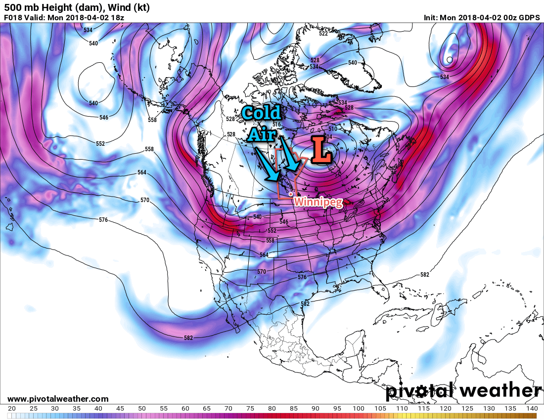
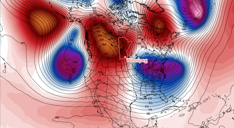
Long Range Outlook

Winnipeg should see more sun to start next week with near-seasonal temperatures. Conditions turn a bit more unsettled mid-week, bringing a slight cool-down and chance for precipitation.

Winnipeg’s seasonal daytime high is currently 10°C while the seasonal overnight low is -2°C.

It’s Cold

And it’s not changing any time soon.

Spring will be decidedly absent in Winnipeg this week as a persistent northwesterly flow aloft over the eastern Prairies continues to usher cold Arctic air southwards. This is all due to a persistent vortex over Hudson Bay that refuses to budge and will remain in the area for the coming 7 days.

GDPS 500mb Height and Winds valid 18Z Monday April 2, 2018
The upper-level wind patterns will continue to usher cold air southwards into Manitoba this week.

Winnipeg will see daytime highs ranging from -10 to -4°C over the next several days, over 10°C below seasonal for this time of year. Overnight lows will be very cold tonight, dipping all the way down to -22°C thanks to the Arctic front which dropped southwards overnight. A weak warm front moving through on Tuesday1 will bring milder, but still well below-seasonal, overnight lows near -15°C for Tuesday and Wednesday night.

Skies will start out mainly sunny today, with a few more clouds moving in on Tuesday and skies becoming mixed on Wednesday.

Winds will be breezy out of the north today at 20 to 30 km/h, then taper off for the night. Winds will be a bit lighter on Tuesday out of the northwest at around 20 km/h, but then strengthen to westerly 30 gusting 50 km/h on Wednesday.

Long Range Outlook

A very gradual warming trend will continue through the remainder of the week, but temperatures are still expected to remain below-normal into next week. Daytime highs should climb back above 0°C this weekend, but will come at the cost of increasing cloud cover and a chance for rain or snow as a low pressure system moves through in the latter half of the weekend into the start of next week.

Booooo!

Winnipeg’s seasonal daytime high is currently 6°C while the seasonal overnight low is -5°C.

  1. Or rather, more like the Arctic air leaving the region.

Pleasant Weather Continues

Benign conditions will continue over the next few days as an upper-level ridge continues to bring seasonable temperatures to Winnipeg. Cloud will begin moving in by the end of the weekend, though, as an upper-level low starts working into the region.

Today and tomorrow will both bring a fair amount of sunshine to Winnipeg with high temperatures near close to 0°C. An area of high pressure slowly slumping southwards will give light southerly winds both days. By Saturday afternoon, some cloud cover will begin spreading into the Red River Valley, becoming cloudy for Saturday night. This blanket of cloud will result in warmer overnight lows, bringing Friday’s expected -13°C up to around -8°C.

Daytime highs will climb towards 0°C in the Red River Valley on Saturday afternoon.

Sunday will bring mainly cloudy skies to Winnipeg as a large upper low complex lifts northeastwards into the province. Daytime highs will continue to sit near 0°C, but the lack of sun and northerly winds near 20 km/h will make it feel cooler. Just a slight chance of flurries will accompany the cloud. Temperatures will dip to around -6°C on Sunday night with an increasing chance of flurries.

Long Range Outlook

The beginning of next week looks a bit more unsettled as a series of upper disturbances moves through. Winnipeg and the Red River Valley will likely see snow on Monday with possible amounts of 2 to 5 cm. Some light snow may persist into Tuesday, but then clearing should work back into the region mid-week. Daytime highs are forecast to hover near the 0°C mark through the first half of the week. For those looking for warmer weather, there are some indications that milder conditions with above-zero temperatures may move in through the second half of the week!

So until then, enjoy the cooler but generally pleasant weather ahead!

Winnipeg’s seasonal daytime high is currently -1°C while the seasonal overnight low is -11°C.

Beautiful Week Ahead

An upper-level ridge building into the Prairies will bring sunny skies and warm temperatures to Winnipeg this week.

Winnipeg will see benign weather over the next few days with plenty of sunshine and mild temperatures. Over the next several days, Winnipeg will see high temperatures in the -2 to 0°C range with winds in the 10 to 20 km/h range. Overnight lows will vary a bit more, ranging from near -8°C to -13°C.

With the mild temperatures and clear skies, there will also be the potential for fog development at night as moisture from the daytime melt is trapped near the surface with cooling temperatures. If you need to travel, particularly outside the City of Winnipeg, keep in mind you may encounter fog patches overnight into the morning on any of the next few days.

Long Range Outlook

The remainder of the week also looks quite pleasant with highs continuing in the -1 to +2°C range. Skies will likely become mixed with cloud late in the week as Winnipeg gets closer to passing low pressure systems. Despite the cloud, the forecast shows dry conditions for the weekend.

The long-range forecast continues to show a good likelihood of near-seasonal temperatures with no significant precipitation events. Enjoy the beautiful spring weather!

Winnipeg’s seasonal daytime high is currently -2°C while the seasonal overnight low is -12°C.