Sunshine Reappears With Pleasant Fall Weather

Those tired of the left-over gloom from the weekend’s weather will be happy to know plenty of sunshine is on the way as a building upper-level ridge brings seasonal temperatures and plenty of sunshine.

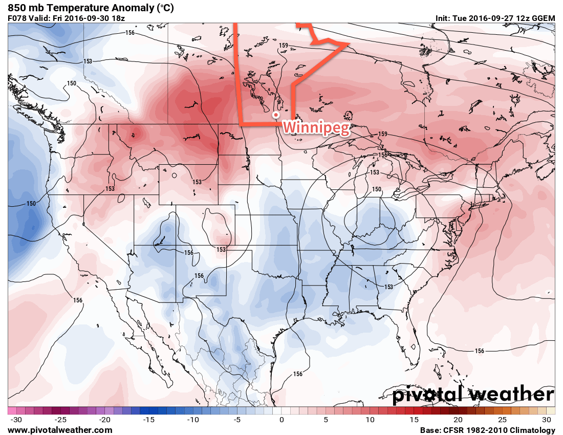
The weather for much of this week will be dominated by an upper ridge building across the southern Prairies, bringing pleasant conditions for the end of September with slightly above normal daytime highs. The next few days will bring plenty of sunshine with just a few clouds to partly cloudy skies expected.

Temperatures will gradually climb to around 5-6°C above seasonal by the end of the week; daytime highs near 17°C today in Winnipeg will increase to near 20°C for Thursday and Friday.

The red colours on this map of 850mb temperature anomalies shows the warmer than normal weather expected over Southern Manitoba this week.

Fortunately, it doesn’t appear the wind will pose too much of an issue either. Winds will be calm today, and then increase to around 10-20 km/h out of the south for Thursday and 15-25 km/h out of the south on Friday.

Long Range

The weekend forecast gets a little more complicated, but overall it’s looking like the weather should stay dry until the start of next week.

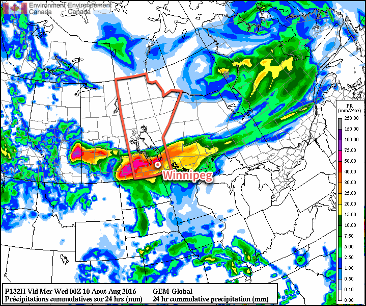
As the weekend progresses, a long-wave upper trough will dig over the western half of the continent. We should remain relatively unaffected by this with mild weather continuing through the weekend. Late Sunday into Monday, a shortwave will eject northeastwards out of the trough, moving into Southern Manitoba, and will bring some rain to the region. The timing of this is uncertain at the moment, but it looks likely that it won’t move into the province until late Sunday at the earliest.

So until that moves in, the weather should remain quite nice with mild temperatures and relatively light winds.

Winnipeg’s seasonal daytime high is currently 15°C while the seasonal overnight low is 4°C.

Drying Out with Seasonal Temperatures

After a rainy weekend we’ll have a chance to dry out this week as skies clear. Temperatures will be cool, but generally near seasonal values.

Cool and windy conditions are expected on Monday in southern Manitoba

This Week

Today will see mainly sunny skies as the low pressure system from the weekend moves off to the east. However, it will remain quite windy behind the system with northwesterly winds of 40 km/h gusting to 60 km/h. Temperatures will sit in the mid teens over most of southern Manitoba. There will be a slight risk of frost in low-lying areas tonight as temperatures drop rapidly with the light northwesterly flow.

Tuesday will see slightly improved weather over today as winds calm down and temperatures climb up into the mid teens. Skies will also remain mainly sunny, making for a generally pleasant day.

Wednesday should be one of the warmest days this week. Temperatures are expected to climb up near the 20C mark under light southerly winds and mainly sunny skies.

Long Range

Long range models hint at another strong low pressure system developing to our west later this week. It remains unclear if and when this system may affect us, but it likely won’t be until the weekend at the earliest. The good news is that this system will draw up a warm, southerly flow, perhaps giving us a brief stretch of warm weather before it arrives.

Ridge of High Pressure Brings Seasonal Temperatures & Dry Weather

In the wake of yesterday’s cold front that brought some wild weather to Manitoba yesterday afternoon & evening, conditions will be significantly more benign as a ridge of high pressure moves into the Red River Valley and brings dry weather with seasonal temperatures.

There is not too much to say for today’s forecast post. Mainly sunny skies will dominate the region today as a ridge of high pressure builds in from the northwest behind yesterday’s cold from that moved across the region.

A ridge of high pressure aligned through Saskatchewan into southwestern Manitoba will bring benign weather to the region.

Winds will be breezy at 20-30 km/h first thing this morning, but will fairly quickly taper off into the 15-20 km/h range. Winds will remain light through Wednesday.

Temperatures will be fairly steady with daytime highs around 23-24°C all 3 days. Overnight lows will be cool, in the 9-11°C range on Monday night and Tuesday night, however slightly milder air begins working in on Wednesday night, bumping the overnight low up towards the mid-teens.

No precipitation is expected. Skies will be mainly sunny both today & Tuesday, however a little more cloud is expected on Wednesday, with sunny skies likely giving way to more mixed conditions in the afternoon.

Long Range

The second half of the week looks to bring warmer conditions back into the region with daytime highs climbing back towards the 27 or 28°C mark with variable cloudiness. Friday evening into Saturday looks to be the first chance of any more precipitation, with thunderstorms possible. At this point, it looks most likely that they would occur overnight into Saturday morning.

So a very pleasant week ahead with little precipitation; it’s nice to finally give some good news!

Winnipeg’s seasonal daytime high is currently 22°C while the seasonal overnight low is 9°C.

Calmer Weather On Tap For The Weekend

Calm weather is expected in Winnipeg and across the Red River Valley over the next few days, a welcome reprieve from the severe thunderstorm activity that moved through the region on Wednesday.

Today will be an improvement over the cool and blustery conditions that moved through the Red River Valley yesterday. While skies will be mixed remain mixed, temperatures will be a couple degrees warmer than Thursday with a high temperature near 23°C. Gusty winds will remain out of the northwest at 20-30 km/h.

Temperatures will dip down to around 13°C tonight with partly cloudy skies.

Saturday will be a very pleasant day as a ridge of high pressure moves over the province. Winnipeg & the Red River Valley will see daytime highs near 25°C under mainly sunny skies and light northwesterly winds. Temperatures will dip down to around 13°C once again on Saturday night under clear skies.

A ridge of high pressure will bring sunshine to Southern Manitoba on Saturday.

Sunday will bring warmer weather back to the Red River Valley as the ridge moves off to the east, winds switch around to the south, and a warm front begins lifting northwards out of the United States. As the warm front moves into the province through the day, skies will become gradually mixed with temperatures climbing into the upper 20s. Fortunately, despite the southerly flow, it appears that the humidity will be kept at bay and the weekend will be ending with warm, comfortable conditions instead of another muggy mess.

Long Range

Early indications are that our nice dry weather will come to an end early next week as yet another low pressure system tracks out of the northern United States and into the southeastern Prairies. This system will spread another batch of thunderstorm activity across southern Manitoba with the main event on Monday night into Tuesday.

The GDPS is forecasting a swath of 30-50mm across Southern Manitoba on Monday night through Tuesday.

Initial indications are that severe weather may also be possible with this system as moderate CAPE values1 combine with 35-45 kt of bulk shear, which in this timeframe certainly indicates the potential for organized thunderstorms with, at a minimum, the potential for large hail. Ultimately we’ll simply have to wait until later in the weekend for clarifying details on what this system early next week will entail.

It’s getting to be a tiring summer to be the weather messenger, with every tiny stretch of nice weather being cut short by the looming news of more thunderstorms. It’s been an incredibly active summer over Southern Manitoba, and one can only hope that we transition into a pattern of more stable, drier weather in the coming weeks.

Winnipeg’s seasonal daytime high is currently 26°C while the seasonal overnight low is 13°C.


  1. CAPE is a measure of the energy available to a thunderstorm.