Quiet Weather with Near-Seasonal Temperatures Will Continue

The quiet weather Winnipeg has seen over the past several days will continue with dry conditions and near-seasonal temperatures continuing to the end of April.

The forecast for the remainder of the work week is brief! "More of the same" will be the mantra for Winnipeg over the coming days with daytime highs in the low teens and variable cloudiness. Today will bring just a few clouds to the Winnipeg region with breezy winds out of the northeast that strengthen to around 30km/h midday and persist into the evening. Tomorrow will bring more of a mixed sky with lighter winds, and Friday is looking like it will be a mainly cloudy day with light winds.

All three days will bring daytime highs in the 12-15°C range and overnight lows from 1-4°C.

Jet stream positions at 02:15Z April 27, 2016
This satellite image from last night shows the two jet streams impacting Manitoba.

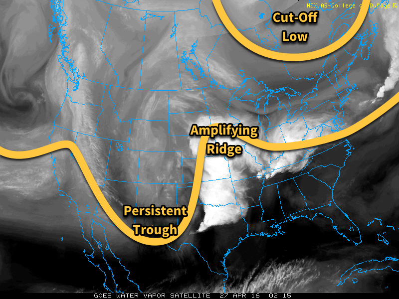
This stagnant weather pattern over the region has been due to a stationary trough over the central United States coupled with a cut-off low over eastern Canada. As we head through the coming days, the trough over the US is will amplify and cut-off, becoming stagnant over the Northern Plains while the ridge builds in response, to the the point where it pushes all the way northwest into Manitoba.

This all means the overall pattern can’t change very much, and we see more of the same. The earliest indication of the potential for change is early next week when, if things turn out as forecast, an upper-level ridge may begin building in over North America, spreading above-normal temperatures through the Prairies.

Winnipeg’s seasonal daytime high is currently 15°C while the seasonal overnight low is 2°C.

Near-Seasonal Conditions Continue

This week will feature near seasonal temperatures and a brisk easterly flow as a stalled upper low sits to our south.

Today will be mainly cloudy, as a low pressure system to our south spreads clouds and showers over southern Manitoba. The main shower activity is expected to remain near the International border, though a few showers may creep a bit further north. Temperatures will be in the low teens with easterly winds at 20-30 km/h.

A low pressure system will sit to our south on Monday

Tuesday will be much the same as Monday, with temperatures in the low to mid teens under mainly cloudy skies. No rain is expected in the Red River Valley, though some light showers may occur in western Manitoba. Winds will be easterly at 20 km/h.

Wednesday will likely see a bit more sun, with skies being a mixture of sun and cloud. High temperatures will be in the mid teens with winds out of the east at 30 km/h.

Long Range

The long range forecast suggests that we will see more above seasonal weather as we move into May. The remainder of April will likely see temperatures around seasonal values, with highs in the mid teens.

Finally, a warm-up!

We’ll finally see a warming trend this week after a nasty weekend of cold, windy, and snowy weather. The persistent trough over central North America will finally lift, allowing warmer air from the west to spill into southern Manitoba.

Today will be relatively nice compared to the nasty weather of the weekend. While temperatures will still be cooler than normal, today’s highs near zero will be pleasant since skies will be sunny and winds will be light. Not a perfect April day by any means, but definitely an improvement.

A warming trend will take hold beginning Tuesday

Tuesday’s weather will see us warm closer to seasonal values, with high temperatures in the mid to upper single digits across southern Manitoba. However, skies are expected to turn mainly cloudy as a weak upper disturbance passes through. Winds will also be gusty from the south at 30 km/h gusting to 50 km/h.

Wednesday is expected to be the first really nice day in awhile, as temperatures climb up around 10C under mainly sunny skies. Winds are also expected to remain light, making for a very pleasant day.

Long Range

There is still some uncertainty as to how warm it will be for the rest of this week. Some models put us close to 20C by Thursday, while others keep us down in the single digits. Time will tell exactly how warm we’ll get this week, but the general trend calls for warmer than normal conditions for the second half of the month.

Photo by @aweathermoment — Instagram

Uneventful Weekend Ahead for Winnipeg

After a stretch of weather that brought record breaking temperatures, record breaking dew points, and new daily rainfall records[1] before shifting into a weird weather pattern that brought moderate-to-heavy snow to much of southern Manitoba (with a rather beautiful aftermath, pictured above), the weather over the coming days will be downright dull as a benign pattern brings seasonal temperatures to Winnipeg.

In a rather nice change of pace, there isn’t too much to talk about regarding this weekend’s weather. Near-seasonal temperatures will be in place throughout the weekend with daytime highs hovering in the 0 to +2°C range while overnight lows hover between -6 to -8°C. Skies will progressively become more cloudy with a sunny day today, a few clouds tomorrow, and mixed skies on Sunday, but no precipitation is expected. Winds will remain quite calm throughout the weekend with the strongest winds on Sunday at just 20km/h or so.

Long Range: More Active Week Ahead

Next week is looking a little more active with a storm system expected to move through on Monday night & Tuesday. It’s too early to try and pin down too many specifics, but overall it appears that it will spread 5-10cm of snow across Southern Manitoba followed by some gusty northerly winds that may produce some local blowing snow.

GDPS 12hr QPF forecast valid 18Z March 22, 2016
The GDPS is showing a solution further south than other long-range models, pushing Tuesday’s system southwards into the United States

Towards the end of next weak it also appears that we may see another weak disturbance produce some light snow over the region.

Temperatures will be fairly consistent next week with daytime highs and overnight lows expected to be near-seasonal.

Winnipeg’s seasonal daytime high is currently 0°C while the seasonal overnight low is -10°C.


  1. See our summary post for more details.  ↩