Last Major Arctic Outbreak of the Winter?

This week will start out with what could be our last arctic outbreak of the winter. Temperatures will remain below seasonal for most of this week, but it appears spring may not be too far away.

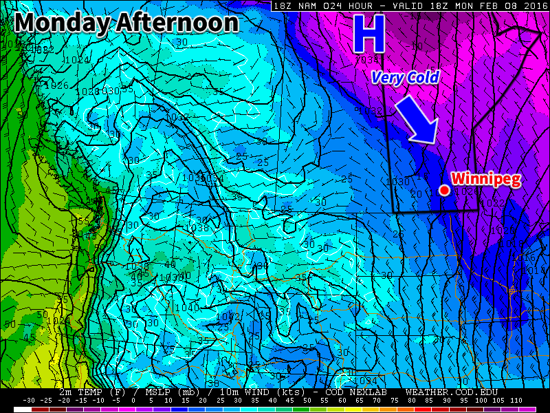
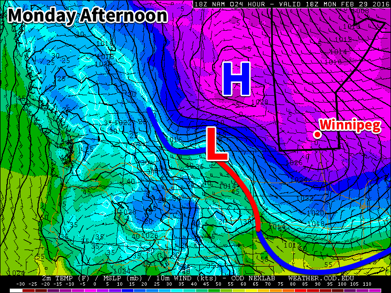
Today will be the coldest day of the week, as high temperatures will be stuck in the upper minus teens. An arctic high pressure system sliding down from the north will be responsible for this cold air mass. The outflow from this high will be breezy from the north-west, pushing wind chill values near the -30 mark for much of the day. On the brighter side, it will be sunny, so at least there’s that (pun fully intended by the way)!

An arctic high pressure system will dominate our weather early this week

Tuesday will see slightly warmer temperatures from today as highs climb into the low minus teens. Skies should remain mainly sunny with lighter westerly winds. The arctic high from Monday will still be hovering around the region, preventing warmer air from pushing in.

Wednesday will be much the same as Tuesday, with high temperatures in the low minus teens and mainly sunny skies. Another arctic high will push down from the north and sit off to our north-east. This should bring north-easterly winds to southern Manitoba, with speeds near 20 km/h.

Long Range

The long range forecast suggests that we should begin to see a shift towards above seasonal weather starting in about a week’s time. Models are beginning to strongly indicate that spring-like conditions will build into southern Manitoba sometime around March 5-8 and last into mid-month. Given the time of year, this warm-up should be accompanied by some decent snow-melt. There isn’t much snow to our south and west, so be prepared for a rapid transition to spring once this warmer pattern arrives!

Colder This Week

This week will be see temperatures trend below seasonal as a surge of arctic air comes down from the north.

Colder weather is expected this week behind the weekend's departing low pressure system
Colder weather is expected this week behind the weekend’s departing low pressure system

Today will be slightly below seasonal as colder air filters southward behind the weekend’s strong low pressure system. High temperatures will be in the low minus teens under clearing skies. Winds will remain stiff out of the north-west at 30km/h gusting to 50km/h. There may still be a bit of drifting snow on the highways with these wind speeds, but heavy blowing snow is not expected.

Tuesday will see a further drop in temperatures as that arctic air mass becomes more entrenched over southern Manitoba. High temperatures will be in the upper minus teens under mainly sunny skies. Winds will remain northerly at about 20km/h. Tuesday night is expected to be quite cold due to the presence of a strong surface ridge of high pressure over the area along with clear skies. Temperatures are expected to drop to around -30C, but luckily wind chill values should not be a significant factor due to the light winds with this high pressure system.

Wednesday will remain cold, with temperatures staying in the upper minus teens. The good part of this colder pattern is that we should continue to see sunny skies on Wednesday. We will be under the centre of a surface high on Wednesday, bringing generally light winds to the region.

Long Range

The long range forecast shows cold conditions sticking around for the rest of the work-week. Models suggest we should warm back up to above-seasonal conditions by the weekend into next week. In the even longer range it appears that we may see one more arctic blast later next week before a more prolonged warm period takes hold towards the end of the month.

Gradually Warming Up This Week

The early part of this week will remain very cold, but gradual warming is expected as the week progresses.

A surface ridge of high pressure will be centred over southern Manitoba on Monday

Monday

A surface ridge of high pressure will be centred over southern Manitoba today, continuing the chilly conditions that have plagued us for some time. The only good part about this ridge is that it will bring light winds to the region, at least keeping wind chill values at bay. High temperatures in southern Manitoba are expected to be near the -20C mark today under clearing skies. There is a slight chance of flurries early in the day before the clouds clear.

Tuesday

Tuesday will see slightly warmer weather in southern Manitoba as the surface high moves off to the east. Skies will be mainly cloudy, helping to maintain these slightly warmer conditions. Due to the presence of these clouds we may see some light flurry activity, but only trace accumulations will be possible. Winds will be noticeable stronger than Monday, with values of 20-30km/h out of the south.

Wednesday

Wednesday will remain mainly cloudy as a weak low pressure system approaches. We may again see some flurry activity throughout the day, but large accumulations are not expected. Some models bring measurable, but still light, accumulations of snow to southern Manitoba on Wednesday, so don’t be surprised if this forecast changes a bit. Winds will be generally light and from the south.

Long Range

The long range forecast shows us continuing to warm as we approach the weekend. Models suggest that late January will generally be warmer than normal (the normal high is currently around -13C). The current El Nino in the Pacific Ocean is hovering around record levels, thus we can expect it to begin more profoundly exerting its influence on our weather again before this winter is over.

2016 Kicks Off With Mild Weather

Winnipeg will be ringing in 2016 with temperatures 5-10°C above normal as a surge of mild Pacific air sweeps across the Prairies.

A gorgeous holiday Friday and weekend is on tap for Winnipeg thanks to a surge of warmer air that swept into the province overnight. Today will bring mainly sunny skies and breezy westerlies at 20-30 km/h. Temperatures will climb to around -4°C for the afternoon with a chance of some cloudiness as a bank of stratus cloud passes mainly to the east of the Red River Valley. Winds will persist out of the west-northwest at about 20 km/h as temperatures dip to to around -10°C.

Tomorrow will bring some afternoon cloud as a weak cool front approaches, but not before temperatures climb to the -3 or -2°C mark! At this point, it doesn’t look like there will be too much cloud on Saturday afternoon as once again, the main area of cloud is forecast to pass east of the Red River Valley. Temperatures will dip to around -12°C on Saturday night before moderating slightly as cloud cover begins building into the Red River Valley.

RDPS Forecast 850mb Temperatures valid 06Z Saturdy Morning
A significant push of warm air sets up over the Red River Valley for Saturday, shown here via the forecast 850mb temperatures.

Sunday looks like the weather takes a bit of a turn for the worse, but the mild weather persists. The cloud that will be tied up to our east over the next couple of days is forecast to finally spill westward and push into the Red River Valley. With that happening, it looks like Sunday will be mainly cloudy, but still mild for early January, with a high near -7°C. The cloud will keep things warm on Sunday night with a low near -10°C.

Long Range

Conditions will remain mild through the week with daytime highs in the -5 to -10°C range. No significant precipitation is expected until possibly the end of the week, so all in all it’s looking great!

NAEFS 8-14 Day Temperature Anomaly Outlook
NAEFS 8-14 Day Temperature Anomaly Outlook valid January 9-16, 2015

In the longer range, models are converging on seasonal temperatures for the region. This would mean occasional snow and highs in the -10 to -15°C range and lows between -20 to -25°C.