Photo by @aweathermoment — Instagram

Uneventful Weekend Ahead for Winnipeg

After a stretch of weather that brought record breaking temperatures, record breaking dew points, and new daily rainfall records[1] before shifting into a weird weather pattern that brought moderate-to-heavy snow to much of southern Manitoba (with a rather beautiful aftermath, pictured above), the weather over the coming days will be downright dull as a benign pattern brings seasonal temperatures to Winnipeg.

In a rather nice change of pace, there isn’t too much to talk about regarding this weekend’s weather. Near-seasonal temperatures will be in place throughout the weekend with daytime highs hovering in the 0 to +2°C range while overnight lows hover between -6 to -8°C. Skies will progressively become more cloudy with a sunny day today, a few clouds tomorrow, and mixed skies on Sunday, but no precipitation is expected. Winds will remain quite calm throughout the weekend with the strongest winds on Sunday at just 20km/h or so.

Long Range: More Active Week Ahead

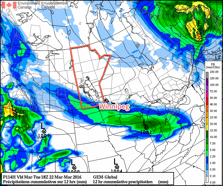
Next week is looking a little more active with a storm system expected to move through on Monday night & Tuesday. It’s too early to try and pin down too many specifics, but overall it appears that it will spread 5-10cm of snow across Southern Manitoba followed by some gusty northerly winds that may produce some local blowing snow.

GDPS 12hr QPF forecast valid 18Z March 22, 2016
The GDPS is showing a solution further south than other long-range models, pushing Tuesday’s system southwards into the United States

Towards the end of next weak it also appears that we may see another weak disturbance produce some light snow over the region.

Temperatures will be fairly consistent next week with daytime highs and overnight lows expected to be near-seasonal.

Winnipeg’s seasonal daytime high is currently 0°C while the seasonal overnight low is -10°C.


  1. See our summary post for more details.  ↩

Last Major Arctic Outbreak of the Winter?

This week will start out with what could be our last arctic outbreak of the winter. Temperatures will remain below seasonal for most of this week, but it appears spring may not be too far away.

Today will be the coldest day of the week, as high temperatures will be stuck in the upper minus teens. An arctic high pressure system sliding down from the north will be responsible for this cold air mass. The outflow from this high will be breezy from the north-west, pushing wind chill values near the -30 mark for much of the day. On the brighter side, it will be sunny, so at least there’s that (pun fully intended by the way)!

An arctic high pressure system will dominate our weather early this week

Tuesday will see slightly warmer temperatures from today as highs climb into the low minus teens. Skies should remain mainly sunny with lighter westerly winds. The arctic high from Monday will still be hovering around the region, preventing warmer air from pushing in.

Wednesday will be much the same as Tuesday, with high temperatures in the low minus teens and mainly sunny skies. Another arctic high will push down from the north and sit off to our north-east. This should bring north-easterly winds to southern Manitoba, with speeds near 20 km/h.

Long Range

The long range forecast suggests that we should begin to see a shift towards above seasonal weather starting in about a week’s time. Models are beginning to strongly indicate that spring-like conditions will build into southern Manitoba sometime around March 5-8 and last into mid-month. Given the time of year, this warm-up should be accompanied by some decent snow-melt. There isn’t much snow to our south and west, so be prepared for a rapid transition to spring once this warmer pattern arrives!

Colder This Week

This week will be see temperatures trend below seasonal as a surge of arctic air comes down from the north.

Colder weather is expected this week behind the weekend's departing low pressure system
Colder weather is expected this week behind the weekend’s departing low pressure system

Today will be slightly below seasonal as colder air filters southward behind the weekend’s strong low pressure system. High temperatures will be in the low minus teens under clearing skies. Winds will remain stiff out of the north-west at 30km/h gusting to 50km/h. There may still be a bit of drifting snow on the highways with these wind speeds, but heavy blowing snow is not expected.

Tuesday will see a further drop in temperatures as that arctic air mass becomes more entrenched over southern Manitoba. High temperatures will be in the upper minus teens under mainly sunny skies. Winds will remain northerly at about 20km/h. Tuesday night is expected to be quite cold due to the presence of a strong surface ridge of high pressure over the area along with clear skies. Temperatures are expected to drop to around -30C, but luckily wind chill values should not be a significant factor due to the light winds with this high pressure system.

Wednesday will remain cold, with temperatures staying in the upper minus teens. The good part of this colder pattern is that we should continue to see sunny skies on Wednesday. We will be under the centre of a surface high on Wednesday, bringing generally light winds to the region.

Long Range

The long range forecast shows cold conditions sticking around for the rest of the work-week. Models suggest we should warm back up to above-seasonal conditions by the weekend into next week. In the even longer range it appears that we may see one more arctic blast later next week before a more prolonged warm period takes hold towards the end of the month.

Gradually Warming Up This Week

The early part of this week will remain very cold, but gradual warming is expected as the week progresses.

A surface ridge of high pressure will be centred over southern Manitoba on Monday

Monday

A surface ridge of high pressure will be centred over southern Manitoba today, continuing the chilly conditions that have plagued us for some time. The only good part about this ridge is that it will bring light winds to the region, at least keeping wind chill values at bay. High temperatures in southern Manitoba are expected to be near the -20C mark today under clearing skies. There is a slight chance of flurries early in the day before the clouds clear.

Tuesday

Tuesday will see slightly warmer weather in southern Manitoba as the surface high moves off to the east. Skies will be mainly cloudy, helping to maintain these slightly warmer conditions. Due to the presence of these clouds we may see some light flurry activity, but only trace accumulations will be possible. Winds will be noticeable stronger than Monday, with values of 20-30km/h out of the south.

Wednesday

Wednesday will remain mainly cloudy as a weak low pressure system approaches. We may again see some flurry activity throughout the day, but large accumulations are not expected. Some models bring measurable, but still light, accumulations of snow to southern Manitoba on Wednesday, so don’t be surprised if this forecast changes a bit. Winds will be generally light and from the south.

Long Range

The long range forecast shows us continuing to warm as we approach the weekend. Models suggest that late January will generally be warmer than normal (the normal high is currently around -13C). The current El Nino in the Pacific Ocean is hovering around record levels, thus we can expect it to begin more profoundly exerting its influence on our weather again before this winter is over.