Summer Temperatures Return as Quiet Weather Continues

Temperatures will be returning to more summer-like values through the second half of this week thanks to an upper-level ridge that will push out the cold air drawn southwards behind this past weekend’s big storm and allow more heat to begin building into the region.

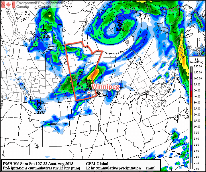
The coming two days will be gorgeous with plenty of sunshine, light winds and warm temperatures. Today will see daytime highs near 26 or 27°C while Thursday will bring highs a degree or two warmer. Overnight lows both nights will be near 12°C. The most significant weather feature will be the significant amounts of smoke that will be pushing into the region sourced from wildfires raging in the northwestern United States. At this point, it seems like it should mainly be aloft and not pose much of an air quality issue.

NAM Forecasted MUCAPE & Bulk Shear valid Friday evening.
The NAM is showing large values of CAPE (energy) and shear on Friday afternoon which suggests the potential for severe thunderstorms.

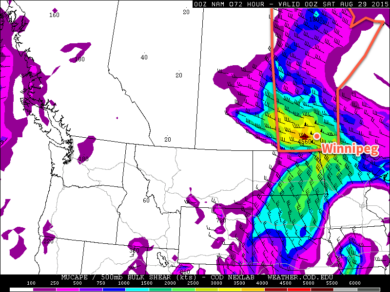
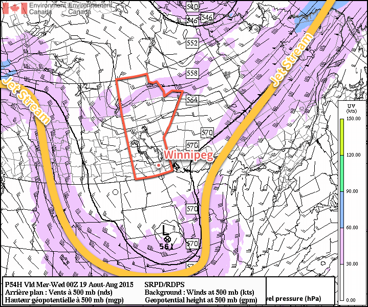
Friday will see a low pressure system moving through the region, bringing warmer temperatures alongside a thunderstorm threat. The major question mark, at this point, appears to be whether or not any smoke in the region inhibits temperatures from climbing high enough to trigger thunderstorms or not. That said, it looks like the potential will be in place for severe thunderstorms with over 3000 J/kg of CAPE expected and over 50 kt of bulk shear in place.

We’ll be taking a closer look at the severe thunderstorm potential on Friday morning in the next blog post, but for now, just keep aware that the threat for severe weather may return to the Red River Valley on Friday.

Other than the storm potential, daytime highs should sit near 30°C with mixed skies. There’s also a reasonable chance that it will be quite humid, making it feel more like the upper 30’s.

Heading through the weekend, it looks like Winnipeg & the Red River Valley will see highs near 30°C with plenty of sunshine, making up for the miserable weather during the last weekend. Other than the blip on Friday, there’s plenty of warm, dry and sunny weather ahead, so enjoy!

Slowly Warming Up

Conditions will slowly warm this week as the weekend’s potent weather system departs our region. Temperatures should return to seasonal values by midweek.

Monday

Today will remain on the cool side, with high temperatures in the upper teens. Winds will remain gusty as well, as we continue to deal with the stiff north-west flow behind the weekend’s low pressure system. Skies will finally become sunny however, which is a welcome change from the grey and rainy conditions of the weekend.

Tuesday

Tuesday will see temperatures warm further, with highs reaching the low twenties. Skies will remain mainly sunny and winds will be light making for a nice day.

Wednesday

Wednesday should see temperatures climb back toward seasonal, or even above-seasonal values. High temperatures will be in the mid to upper twenties as we return to a mild southerly flow. Skies may be somewhat variable due to the passage of an upper-level disturbance.

Seasonal Weather Ahead, Rain Possible At Week’s End

Benign weather will continue over the Red River Valley for the next few days as a weak ridge of high pressure remains entrenched over the region until Friday. Heading into the weekend, however, it looks like rain may be possible as a low pressure system moves into the region through the day.

There isn’t a whole lot to say regarding the coming days, so I’ll keep this post fairly brief! The weather for today and tomorrow will be largely dictated by a weak ridge of high pressure over the region that’s more a result of larger low pressure systems to our west and east than being particularly potent in and of itself.

Today will see temperatures climb to around 23°C with breezy winds building out of the north to 30–40km/h thanks to a low pressure system passing to our east. The day will start overcast with some mid- to high-level cloud that will gradually clear out through the day. Winds will taper off this evening as low temperatures head to around 9°C.

Thursday will be mainly sunny day with light winds and a high near 25°C. Expect a low near 13°C on Thursday night.

GDPS 12hr. QPF valid through Friday Night
The GDPS is showing a low pressure system moving through Southern Manitboa on Friday night capable of bringing some rain to the Red River Valley.

Friday will see increasing cloudiness, particularly in the afternoon as a low pressure system begins working into the region. Temperatures will climb to around 25°C. Friday night will likely bring some rain, although specifics are still quite fuzzy. Temperatures will dip back down to around 13°C again.

Mixed Weekend

This weekend looks mixed at this point, with slightly cooler, cloudier weather on Saturday with a chance of showers and sunnier conditions on Sunday. There’s quite a bit of uncertainty with Friday night/Saturday’s low pressure system, so it’s a bit early to make much in the way of concrete forecasts. High temperatures will likely be in the low 20’s with a chance of warmer weather returning for the beginning of next week.

A Much Cooler Start to the Week

After last week’s high heat and humidity, the much cooler conditions this week will come as a relief to many. However, it might be a little bit too cool, with temperatures only hovering around 20C.

Today will be cool, but fairly pleasant. Temperatures will be near the 20C mark in southern Manitoba under a mixture of sun and cloud. Winds will be light as a surface ridge of high pressure will be in place over southern Manitoba. Portions of western Manitoba may have a slight chance of a shower, but otherwise no precipitation is expected.

Forecast 500mb Winds with Jetstream Annotation from the RDPS
A deep trough over the Central Prairies will deflect the jet stream well to our south, bringing unseasonably cool weather to most of the Prairies.

Tuesday will see little change in conditions from Monday. High temperatures will remain near 20C, with mainly sunny skies. Winds will be from the north-east at 20km/h.

Wednesday will once again be seasonably cool with temperatures in the low twenties. Skies are expected to be a mixture of sun and cloud with breezy winds out of the north.

Long Range

The long range forecast shows generally seasonable to below seasonable temperatures in southern Manitoba over the next week. However, we may see more surges of warm air as move move toward the end of the month.