Mid-Week Warm-Up Gives Way to a Stormy Return to the Cold

Manitobans can enjoy slight relief from the bitter cold that has been in place the last few days as more seasonal temperatures are in place thanks to a fairly large low pressure system passing through Hudson Bay that has dragged the warm air all the way east from the Rocky Mountains. Unfortunately, the milder weather will be short lived as a series of cold fronts sweep southwards into the United States ushering the colder air back into the region.

Wednesday
-11°C / -17°C
Mixed skies with a slight chance of flurries
Thursday
-14°C / -17°C
Increasing cloud
Friday
-15°C / -19°C
Partly cloudy

Temperatures will climb to around –11°C today with mixed skies as a warm front slides through the region from the northwest. There will be a slight chance of flurries, particularly first thing in the morning and again in the evening into the overnight period, but otherwise it will be a seasonally nice day with westerly winds at 30–40km/h. Expect temperatures to drop to around –17°C tonight.

Thursday will be a bit of an in between day; a weak cold front passing through will bring daytime highs cooler than Wednesday – somewhere around –14°C or so – and a fairly sunny start to the day. By the afternoon, more cloud should begin working its way in from the west alongside the next low approaching from Saskatchewan. Little in the way of snow is expected here on Thursday or Thursday night and winds will be relatively light. Temperatures will dip back down to –17°C once again on Thursday night.

Friday will be the sunniest day of the second half of the week. A slight chance of some morning flurries will quickly clear out as we head to a high of around –15°C with light winds. However, a storm is brewing, and by Friday evening an Alberta clipper will be making its way into Southern Manitoba, set to pack a compact wallop as it moves through Friday night and Saturday.

End-of-Week Alberta Clipper Brings Winter Storm to Manitoba

An Alberta Clipper is forecast to track across Southern Manitoba Friday night into Saturday, bringing with it a significant shot of snow, strong winds, and then a plummet back into frigid Arctic air.

Note: Alberta clippers are compact systems whose impact depends significantly on their track. As we’re still several days out from this system, please take the following as just general guidance and remember that with a slight change in track, significant changes in the weather could be seen for any one location.

Snow will spread eastwards into southwestern Manitoba and the Parkland region on Friday evening, progressing across the remainder of the province through the evening hours. A relatively sharp deformation zone will set up across the Parkland & Interlake regions, limiting the northward extent of the snow. While many regions will see accumulating snow, the greatest amounts will be along the Trans-Canada corridor and the western escarpment of the Red River Valley.

First-guess snowfall amounts for the upcoming storm system this weekend.

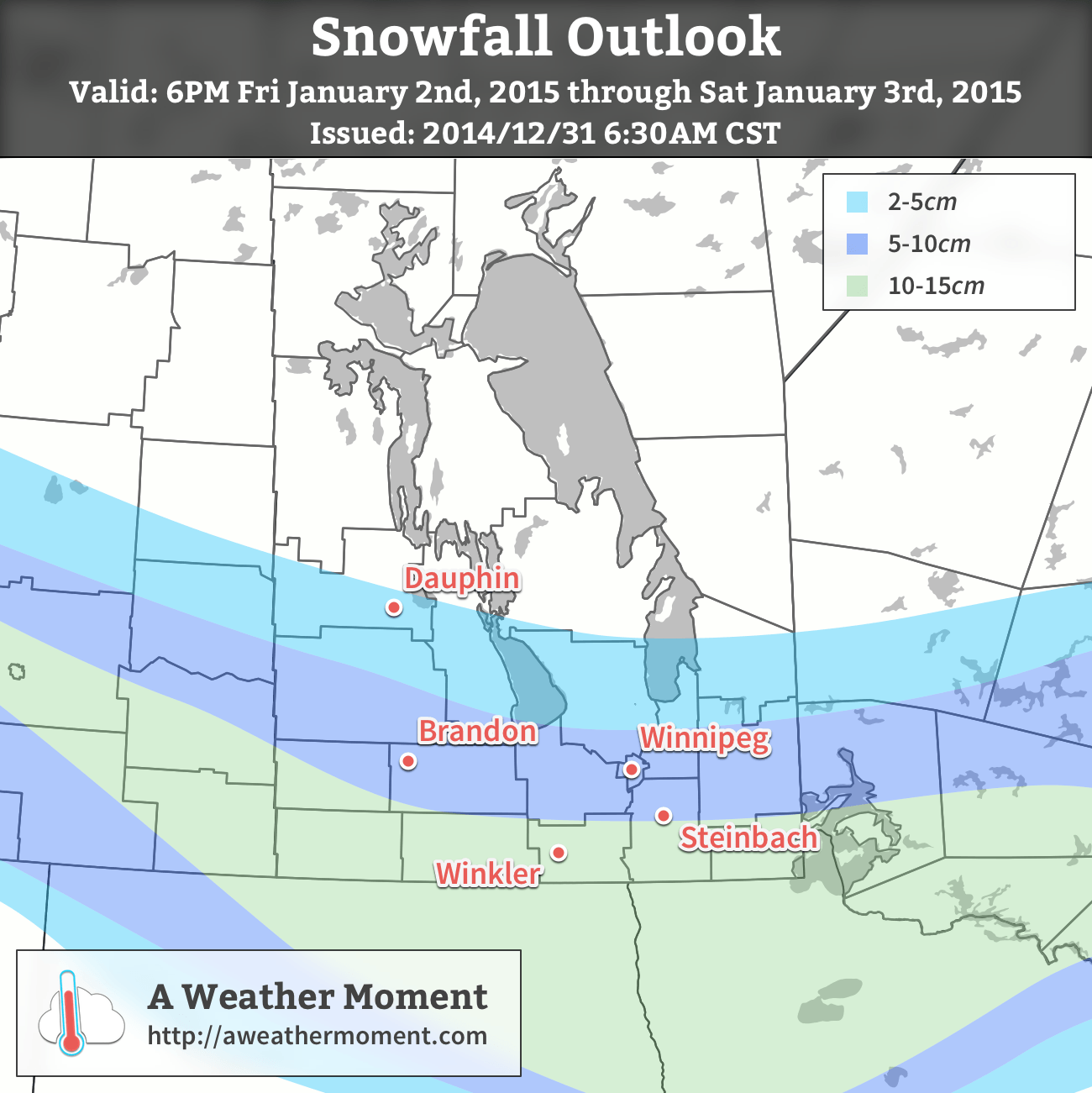
By the time the snow stops on Saturday evening, around 10–15cm of snow may have fallen in a large swath encompassing much of the Trans-Canada corridor and areas south to the U.S. border. An area of higher snowfall will likely develop somewhere near the US border, perhaps just south into North Dakota, depending significantly on where & when the system pivots and begins heading E/NE instead of SE. In the core of heaviest snowfall, as much as 15–25cm of snowfall looks possible. Much of the Parkland and southern Interlake will see between 4–8cm, with amounts tapering off fairly quickly north of that.

In addition to the snow, this system will have fairly strong winds associated with it. Ahead of the low, easterly to northeasterly winds will strengthen to a gusty 30–40km/h. As the system passes through, winds will strengthen out of the northwest to around 50km/h with gusts as high as 70–75km/h. The strong northwesterly winds coupled with the ample fresh snow will likely produce blizzard conditions and make travel dangerous on Saturday. If you have travel plans, make a plan B in case this forecast happens to be right.

Temperatures will reach a high around –15°C on Saturday and then plummet to around –30°C on Saturday night with wind chill values near –45. Sunday looks clear and bitterly cold with a high of only around –26°C coupled with 20–30km/h winds that will produce wind chill values in the –35 to –40 range. If these wind chill values materalize, we’ll likely see extreme cold warnings issued for much of Southern Manitoba through the weekend.[1]

As mentioned, there is potentially significant variability to this forecast and what I’ve presented is the current most likely scenario. I’ll be keeping tabs on this system through the week and provide updates in the comments below and another full look at it in Friday morning’s blog post.


  1. If the extreme cold occurs while blizzard conditions are ongoing, the blizzard warning would “include” the extreme cold.  ↩

March to end with a Bang

This March not only came in like a lion, it will also go out like a lion. A major winter storm will slam the American Red River Valley and parts of south-eastern Manitoba today. Read on for the details.

A Colorado Low will bring heavy snow to parts of southern Manitoba and the northern United States on Monday

Monday

Monday
-9°C / -15°C
Snow, heavy in some areas. Windy.

A Colorado Low will bring heavy snow and high winds to the Red River Valley and south-eastern Manitoba today. Wind speeds will range from 40-50km/h gusting to 50-70km/h. Some areas may even see winds as high as 60km/h gusting to 80km/h for a period of time. This will produce blizzard conditions in open areas of the Red River Valley and south-eastern Manitoba. The map below illustrates the expected snowfall totals.

Expected storm-total snowfall amounts.

Travel will become very difficult, if not impossible from points south of Winnipeg and into the American Red River Valley as the day progresses. Highway closures are likely through the day, with some roadways possibly staying closed until Tuesday. Roads that remain open will be in poor shape as well, so those traveling today may need to reconsider their plans.

This storm will wind down on Tuesday as the snow ends and the wind begins to decrease. However, those areas that saw the heaviest snow will have to deal with large snow drifts on Tuesday. Travel will be difficult if not impossible, particularly in the American Red River Valley, on most of Monday and likely into Tuesday as well. Luckily this storm should signal the beginning of the end of the seemingly endless winter we’ve endured.

Tuesday

Tuesday
-8°C / -22°C
Mainly Sunny

Tuesday will be a much calmer day in southern Manitoba. Temperatures will warm into the minus single digits, but a north-west wind will linger as Monday’s storm departs. At least it will be decent shoveling weather…

Wednesday

Wednesday
-4°C / -18°C
Mainly Sunny

Wednesday will see further improvement over Tuesday, as temperatures climb into the low to mid minus single digits. That should be good enough for some light melting of snow off dark surfaces – melting that can’t come soon enough for most people.

Long Range

The long range forecast is looking good for a change. Most models suggest we’ll see near normal weather in the short to medium term, which means high temperatures in the mid positive single digits. That should help to gradually start wearing down our snow pack.

The Snowy Descent

Take heart and treasure the mild weather we have this morning; the Arctic cold front is on it’s way and through a series of low pressure systems we’ll see a snowy couple days drag us back into the icy grip of winter.

Friday
3°C ⇘ -12°C / -25°C
Light snow beginning midday. 2-4cm. Clearing & windy in the afternoon.

Saturday
-17°C / -24°C
Increasing cloud in the afternoon; snow overnight.

Sunday
-19°C / -30°C
Risk of a blizzard. Snow ending midday. Windy.

Mild Weather Forced Out

Our daytime high will not happen this afternoon. In fact, it will be roughly around where we are at the time of this being posted; an expected high temperature of -3°C sits only a couple degrees above where we are at right now and then we’ll see temperatures start going the wrong way behind a cold front set to push through midday.

We may see a few flurries this morning but the more organized precipitation will hold off until midday when a cold front begins working it’s way southwards. Complicating things will be an upper level shortwave that is rippling down in a northwest flow will ride along the frontal boundary and provide additional lift, helping make snow a little more widespread than it would be otherwise. Due to that, most areas across Southern Manitoba will see some snow through midday as everything passes through. Significant amounts are not expected as mid-level moisture will be somewhat lacking and limit the amount of snow that can be produced. In general, around 2-3cm will be seen in many areas. There’s a slight chance we’ll see a little more in the southwest Red River Valley – near Morden, Winkler, Altona & Gretna – thanks to a closer proximity to the upper-level shortwave and a little more mid-level moisture. Even there, though, I don’t expect to see more than 4 or 5cm.

The snow will taper off this afternoon and stronger northerly winds will develop to around 30 gusting 50km/h. Some local blowing snow might develop through the afternoon, but it shouldn’t be a widespread issue. Temperatures will begin tanking as the northerly wind ushers in cooler Arctic air, but fortunately the big cool-off will hold off a couple more days. Temperatures should drop through the afternoon to somewhere between -10 to -15°C by evening and then onwards to an overnight low close to -26°C or so under clear skies and diminishing winds.

A Cool, Calm Day

GDPS 850mb temperature forecast for Saturday showing a strong baroclinic zone through the Prairies.

Saturday will bring fairly benign weather and act as our calm before the storm. A cold, sunny start to the day will go on to see a high around -17°C under increasing cloudiness as a compact but powerful system zips towards the province along a strong baroclinic zone. A few flurries are possible anywhere there’s cloud, but the organized snow will push into Western Manitoba midday and work it’s way towards the Red River Valley by evening. Around 5cm will fall over Western Manitoba while just 2-4cm are expected here in the valley with the potential for some higher amounts along the western escarpment thanks to an upslope flow that will develop overnight.

Winds will remain fairly light throughout the day and night. Flurries will persist until Sunday morning and we’ll drop to an overnight low of around -24°C.

Miserable Weather for Sunday

The NAM (among others) is forecastinga strong pressure gradient over Southern Manitoba on Sunday.
The NAM (among others) is forecasting a strong pressure gradient over Southern Manitoba on Sunday.

The big story behind the departing low pressure system on Sunday will be the absolutely massive Arctic ridge racing into the Prairies behind it. A very strong pressure gradient is set to develop over Southern Manitoba which will produce strong winds. At this point, it looks like winds will steadily increase early Sunday morning to 40 gusting 60km/h in most places. Through the southern Red River Valley winds will likely climb into the 50-60km/h range thanks to the funnelling effect of the terrain.

Anyone with highway travel plans for Sunday should keep updated on the weather conditions and be prepared for potentially hazardous weather conditions with near-zero visibility on highways.

These strong winds, combined with instability in the low-levels thanks to more cold air pushing southwards and the fresh snow of the past couple days will very likely produce widespread blowing snow. It does look like a blizzard may be possible, although things may end up being a little too marginal. For a blizzard on the Prairies, Environment Canada requires:

  1. Winds of at least 40km/h or greater.
  2. Visibilities of 1/4SM (400m) or less in blowing snow or blowing snow with falling snow.
  3. Both (1) and (2) lasting for 4 hours or more.

The best chance for blizzard conditions will be south of Winnipeg in the Red River Valley and southwards into North Dakota. A strong pressure gradient coupled with ample fresh snow and the funnelling effect of the valley will likely make it quite easy to go down to near-zero visibility. For most other regions, a blowing snow warning seems very possible[1]. Either way, highway travel will likely be poor-to-closed on Sunday. We’ll keep an eye on this as it develops and provide updates a little later this weekend on how things look to be shaping up for Sunday.

Other than the winds, we’ll see skies clear out through the day and our temperature remain steady from Saturday’s low or dropping slightly. The winds will taper off in the late afternoon and we’ll head to a low near -30°C.

Blizzard Update

Right now it looks like this may be the most significant ground blizzard of the winter so far.

Everything seems to be fairly lined up for a significant blizzard event to develop overnight tonight. Winds will begin to pick up through SW Manitoba late overnight and slowly spread eastwards towards the Red River Valley by midday. At this point, it seems like widespread winds of 40-50km/h are possible, although it is possible the winds strengthen as high as 50-60km/h in some areas. Gusts to 70-80km/h are quite likely throughout much of Southern Manitoba.

Widespread blowing snow is expected on Sunday. Maximum blizzard potential exists through SW Manitoba, the western Red River Valley and southwards into North Dakota.

These strong winds will work in tandem with fairly deep low-level instability and a surprising amount of moisture to make very favourable conditions for blowing snow. The strong winds will persist for at least 6-9 hours in most places, making a long-term blowing snow or blizzard event quite likely. If you have any plans to travel on highways in Southwest Manitoba or the Red River Valley on Sunday, it is best to give yourself ample time & make alternate arrangements; white-out conditions are very likely and some highways may be closed. Right now it looks like this may be the most significant ground blizzard of the winter so far.

This blizzard event will extend all the way southwards into North Dakota where there is absolutely no question that a significant ground blizzard will be underway. Just to repeat, conditions will get worse as one travels south. Winds will begin to ease and let conditions improve from north to south through the evening hours.

All in all it will be a lousy day for highway travel. Don’t do it if you don’t have to and stay safe.


  1. Like a blizzard warning, but only requires 1/2SM visibility (800m) and 3 hour duration.  ↩

Unsettled Pattern Continues

Residents in the Red River Valley have barely had time to get the shovels out after Wednesday’s snowfall and Thursday’s blowing snow/blizzard, but more snow and wind is on the way as another system tracks through today. The unsettled weather will continue through the weekend with a brief improvement on Saturday followed by more unsettled weather on Sunday.

Friday
-8°C / -10°C
Increasing cloud in the afternoon then snow. 4-8cm accumulation.

Saturday
-7°C / -9°C
A mix of sun and cloud. Blowing snow in the morning. Chance of flurries.

Sunday
-5°C / -20°C
Light snow developing through the day.

Another Shot of Snow Tonight

More snow is on the way later today through tonight as another low pressure system dives southeastwards through the province. Before that, though, we’ll see mainly sunny skies with relatively light winds out of the south at only around 20-30km/h by the afternoon. The temperature should climb up to around -8°C in Winnipeg while areas closer to the U.S. border may see the temperature get as high as -5°C or so.

Expected storm-total snowfall amounts by Saturday morning.

Cloud and snow will stream in fairly quickly from the northwest later this afternoon as the low pressure system begins slumping southwards through the Interlake. The heaviest snowfall will fall before midnight with lighter flurries persisting thereafter into the early morning. The snow will taper off by tomorrow morning with totals generally between 4-8cm through Winnipeg & most of the Red River Valley.

Blizzard conditions may develop in the southwestern Red River Valley thanks to the funnelling effect of the western escarpment.

Winds won’t be as strong as Wednesday through the snowfall event – around 30km/h gusting to 50 or so in Winnipeg and the eastern Red River Valley and a little bit stronger in the western Red River Valley at around 40 gusting 60km/h. There will be some blowing snow through the overnight period, but I don’t think we’ll see anything as extensive as on Wednesday night into Thursday. The one caveat may be the southwestern Red River Valley[1] where blizzard conditions may develop thanks to a funnelling effect of the western escarpment. Winds may climb up to 50 gusting 70km/h which should be enough to produce a widespread white-out. The strong winds will move in overnight and taper off midday tomorrow.

Nice Start to Weekend, Snowy End

Skies will clear out early Saturday morning with any blowing snow hanging on a little longer until the winds die down. Otherwise we’ll see mixed skies with a high near -7°C with fairly light winds. There will be a slight chance of a flurry or two, but no accumulations are expected.

We’ll drop to an overnight low of just -9°C[2] as more cloud cover begins working it’s way in ahead of another disturbance on it’s way. There will be a continued chance for some isolated flurries overnight.

Sunday will be a mainly cloudy day with snow developing through the afternoon. We’ll climb up to a high of around -5°C. The snow will taper off through the evening on Sunday with some breezy northerly winds producing some blowing snow through the Red River Valley. At this point it doesn’t look too bad, fortunately. Skies will clear Sunday night and we’ll drop to an overnight low of around -20°C.

We’ll continue on an unsettled track through next week as very cold Arctic air begins pushing it’s way back into the region. It seems like we’ll be seeing overnight lows near -30 to -35°C in the latter half of the week, so enjoy the upcoming mild weather!


  1. Areas near Carman, Altona, Winkler, Morden, and Emerson are most likely.  ↩
  2. An overnight low that’s warmer than our normal daytime high for January 17th!  ↩