Mid-January Storm To Bring All Manner of Nasty Weather

A powerful storm system is pushing into Southern Manitoba this morning and will become the first major storm of the year. This storm will impact the entirety of Manitoba and bring very strong winds, heavy snow, near-blizzard conditions and a good chance of some freezing rain. Read on to find out where will see what as we break this thing down.

  • Significant weather expected: strong winds (and blowing snow), freezing rain and heavy snowfall.

  • Expected storm-total snowfall amounts from this system.

Disclaimer: I could write many more words than I have time to write about this system. As such, I’m going to just explicitly state right now that while I may mention areas outside the Red River Valley, the focus of this post will be for the weather expected in Winnipeg & the Red River Valley.

We’ll start out with the good news: temperatures are expected to stay near or above normal[1] through the remainder of the week; no horribly cold Arctic air is expected to slam southwards into the Prairies with this system. That’s about where the good news ends, though.

As we progress through this morning, an area of snow will move into the Red River Valley, pushing in from the west ahead of the incoming warm front. The low pressure centre is currently in northeastern Saskatchewan and will begin to dive southeast into Central Manitoba later this morning. Winds will strengthen out of the south this morning up to around 40-50km/h with gusts as high as 70km/h. Despite the relatively mild temperatures – we’re sitting at around -10°C – extensive blowing snow will likely be an issue in areas to the south of Winnipeg[2] thanks to the strength of the winds.

Wednesday

3°C / -11°C
Snow beginning this morning. Very windy. Risk of freezing rain this afternoon. Flurries overnight with blizzard conditions in the Red River Valley.

The heaviest snowfall will pass to the north and east of the city where a heavy snowfall warning is in effect for 10-15cm of snow. Here in the Red River Valley we’ll see a fair gradient in snowfall amounts from the southwest corner to the northeast corner thanks to how the precipitation spreads in from northwest to southeast. Through the day today, areas in the southwest corner can expect the lighter end of the snowfall with only around 2-5cm accumulation by the evening. Here in Winnipeg we’ll see from 5-10cm of snow while closer to 10cm of snow will fall to our north and east.

Our winds, as mentioned before, will become quite strong out of the south. They’ll lighten a little bit for the early afternoon as they swing to the west as the low pressure system moves through the Interlake and the warm front pushes east of the Red River Valley. Our temperature will jump up to around +2 or +3°C and we’ll see a break in any blowing snow that’s happening. By mid-to-late afternoon, though, a cold front will be approaching. Winds will shift a little more to the northwest and we’ll see a risk for some freezing rain just ahead of and along the cold front as it pushes through. In addition, there is the potential for some fairly heavy bursts of snow along the cold front with some models hinting that there may be a fair amount of convective activity associated with it[3]. Winds will shift straight out of the northwest by the evening and strengthen considerably to 50km/h with gusts potentially as high as 80km/h overnight here in Winnipeg.

This wind will readily whip up the freshly fallen snow in the RRV and produce near-zero or white-out conditions on area highways. Despite the fact that temperatures will not drop too quickly – only to around -10°C overnight – it will still be a brutal night. Continued flurry activity will likely continue through the night, compounding the visibility problems presented by the winds alone.

Thursday


⇒ -10°C / -20°C
Windy with blowing snow. Mainly cloudy.

The snow will taper off early on Thursday, but poor visibilities will continue through much of the day as the strong northwest winds persist at 40-50km/h at least into the early afternoon. Temperatures will remain fairly steady at around -10°C.

By evening the wind will taper off as a ridge of high pressure moves into the province, bringing an end to any blowing snow left in the Red River Valley. The clouds will also scatter out and we’ll drop to a chilly -21°C for our overnight low.

Friday & The Weekend


-10°C / -14°C
Cloudy periods with a chance of afternoon flurries.

Friday will start off sunny but some cloudy periods will develop as a warm front pushes into the Red River Valley. We’ll become overcast in the mid-to-late afternoon and see a chance for a few flurries as the warm front pushes eastwards. This front will usher in warmer air for the weekend with highs near the 0°C mark and overnight lows dropping just shy of around -10°C.


  1. Normal daytime highs are around -13°C for mid-January.  ↩
  2. As usual, with a southerly wind the highways that will be affected most are those that run west/east.  ↩
  3. As evidenced by lightning in Northern Alberta last night.  ↩

Elsewhere in Weather News: January 4th, 2014

Snowstorm Sweeps across Northeast US, Cold Temperatures Follow

A powerful low off the Atlantic coast impacted the Northeast US this past Thursday/Friday bringing heavy snow to the region and blizzard-like conditions. Blizzard warnings were issued for Cape Cod and surrounding regions as winds howled around 70km/h and heavy snow fell. Conditions did improve snow-wise late Friday, but very cold Arctic air ushered in behind the low was of concern. In total, about 4,500 flights were cancelled out of New York alone, causing problems for holiday travelers. Schools and most government offices were closed in Washington DC on Friday due to the adverse weather conditions. Boxford, Mass appeared to be hardest hit with snowfall totals around 60cm, however, Boston was not far behind with 45cm followed by New York’s 25cm. On Friday night 16 deaths had been reported to be associated with the storm.

Temperatures are expected to rebound and warm up for the Northeast as another low pressure system approaches, from the west. It will draw in some warm air; highs Sunday (overnight) are even expected to rise in the (positive) double digits making for a 30°C temperature swing in less than 48 hours for parts of the Northeast.


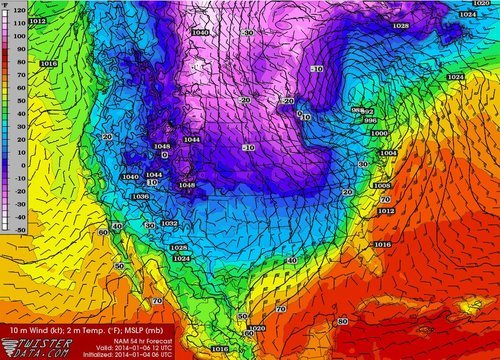
Arctic air infiltrates across the Northern Plains, US Midwest behind the low centered in southern Quebec. Valid Monday morning. (Source: Twisterdata)

Some potentially record-breaking low temperatures are expected on the horizon for the Midwest behind this system though, as the polar vortex pivots all the way down to the Midwest. On Friday the Governor of Minnesota had already cancelled schools state-wide on Monday in preparation for this next potent blast of Arctic air that will make its way east.

Storm Brewing?

Our weather may be about to take a turn towards more active conditions, as a major winter storm looms this week.

A Powerful Low Pressure System is Forecast to Impact Southern Manitoba on Tuesday

Monday

Monday

Cloudy. Snow.
-4°C / -8°C

The weather will begin to take a sour turn on Monday, with some initial bands of snow moving through Southern Manitoba. Areas along the International Border could see 5-10cm of snow through the day on Monday, with areas further north receiving 2-5cm. Temperatures will remain in the single digits with gusty north-east winds.

Tuesday

Tuesday

Snow. Blizzard Possible.
-8°C / -15°C

Tuesday is when things could really get ugly. As of Sunday evening, models were suggesting that this winter storm may move into north-western Minnesota on Tuesday evening, with it’s pressure dropping below 1000mb. At the same time, an arctic high is forecast to slide down into Alberta, generating a large pressure difference across the prairies. This pressure difference will generate very strong winds by late Tuesday. If this storm also produces snow in Southern Manitoba on Tuesday as we currently expect, then the combination of that snow and very strong winds will generate blizzard conditions. Total snowfall on Tuesday into Tuesday night could be 10-20cm in Southern Manitoba along with wind speeds of 40-50km/h gusting to 60-70km/h. Travel may become very difficult to impossible by Tuesday night.

Wednesday

Wednesday

Blizzard Ending
-15°C / -20°C

Snow may continue into Wednesday morning, along with the strong winds. If this storm tracks as currently expected we could see blizzard conditions persisting through a good part of Wednesday in Southern Manitoba. The wind should taper off somewhat on Wednesday night, but it will remain breezy on Thursday.

Long Range

The long range forecast is pretty simple – it will be COLD! After this week’s weather system departs on Wednesday we will see arctic air take over, and it will be the coldest airmass so far this season.

Not a Great Start to the Week

This week hasn’t exactly started out on a pleasant note as you’re no doubt aware. Unfortunately, conditions won’t improve much after today.

image

Predicted conditions early Monday afternoon (courtesy: College of Dupage NAM model)
Monday
image
Snow ending. Blowing snow.
-12°C / -21°C

Monday

Snow and heavy blowing snow is currently ongoing in parts of the Red River Valley. This snow and blowing snow will gradually taper off today, but not before snow totals of 10 to 20cm have piled up across Southern Manitoba. High temperatures today won’t be very pleasant, nor will low temperatures tonight. Overall a horrible start to the week.

Tuesday and Wednesday

Tuesday
image
Mainly cloudy
-12°C / -22°C
Wednesday
image
Mix of sun and cloud
-11°C / -21°C

Conditions on Tuesday will see little improvement from Monday. Highs will once again be very cold by March standards. Luckily no more precipitation is expected on Tuesday (except maybe a flurry here or there), which is at least something to be thankful for. Wednesday will again be a seasonably cold day, with no weather of note.

Long Range

The long range is…you guessed it, ugly. At this point the GFS model (a longer range model) doesn’t show us even getting to the freezing mark in the next ten days. While this may be an overly pessimistic forecast, it is certainly possible given the extensive snowpack over the Eastern Prairies. We can only hope it is wrong, and perhaps we’ll see at least some melting, however minimal, by the weekend.