Winter Cold Continues Through the Weekend

Below-normal temperatures will stick around through the Christmas weekend, but a warm-up is on the horizon.

RDPS 2m Temperature Forecast valid 12Z Sunday December 25, 2022
It will be a cold start to Christmas Day in southern Manitoba with temperatures near -30 °C, but warmer air will already be pushing towards the region in Saskatchewan.

While temperatures in Manitoba haven’t quite compared to the extreme cold anchored over Alberta and impacting much of western Canada, the region continues to see seasonably cold conditions. Fortunately for our region, it won’t get too much worse than seen so .

The detached lobe of the Polar Vortex that has brought such bitter cold to the western Prairies is now spinning its way into eastern Canada and is set to bring a significant winter storm to the region. As it departs, temperatures will cool slightly here in Manitoba, followed by a gradual warming trend.

Daytime highs will hover around the -20 °C mark for the next few days in Winnipeg with increasing sunshine later today into Saturday. Lows will generally sit in the -25 to -30 °C range, but there’s a chance of a sub-minus 30 reading.

Wind chill will be a bit of an issue the next couple days with moderate northwest winds of 30 to 40 km/h. Wind chill values will hover in the -30 to -40 range much of the next couple days.

Those winds will also bring some blowing snow to the region. Today will be the worst for it, with blowing snow possible in most of the open areas in the Red River Valley. Lighter winds into Saturday will make it a more localized issue then.

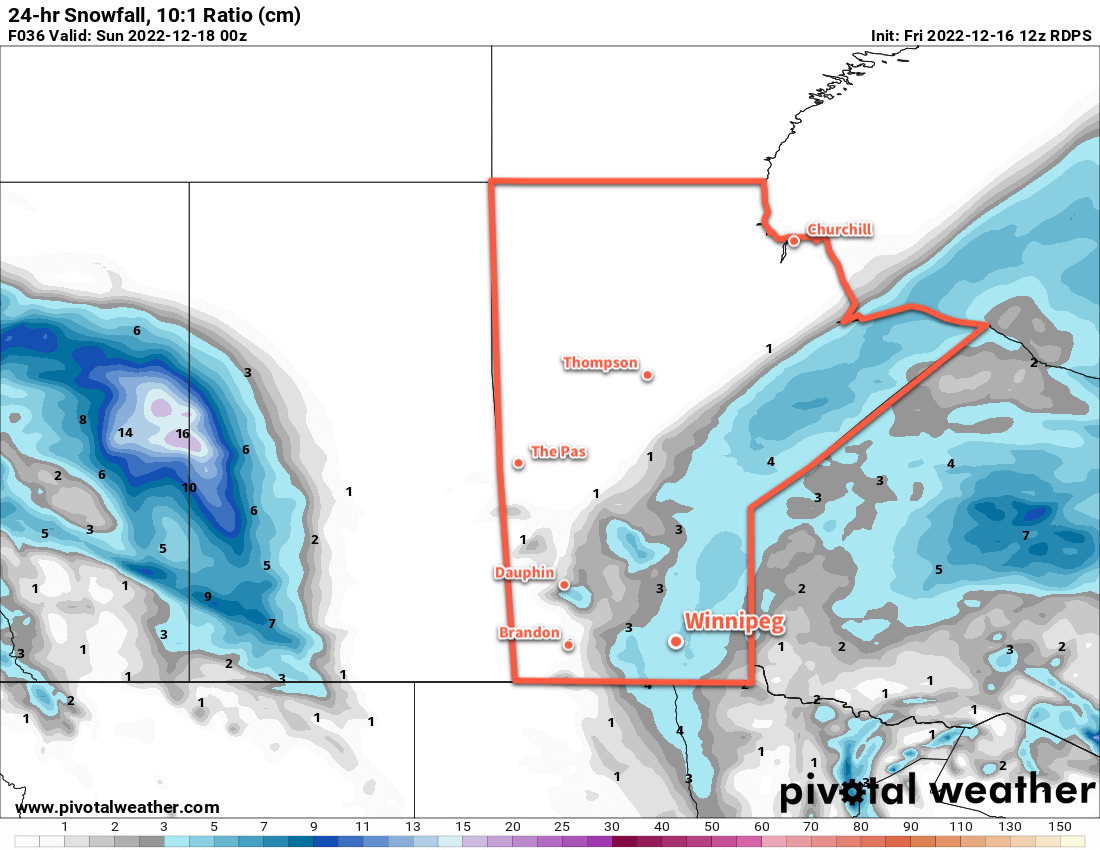
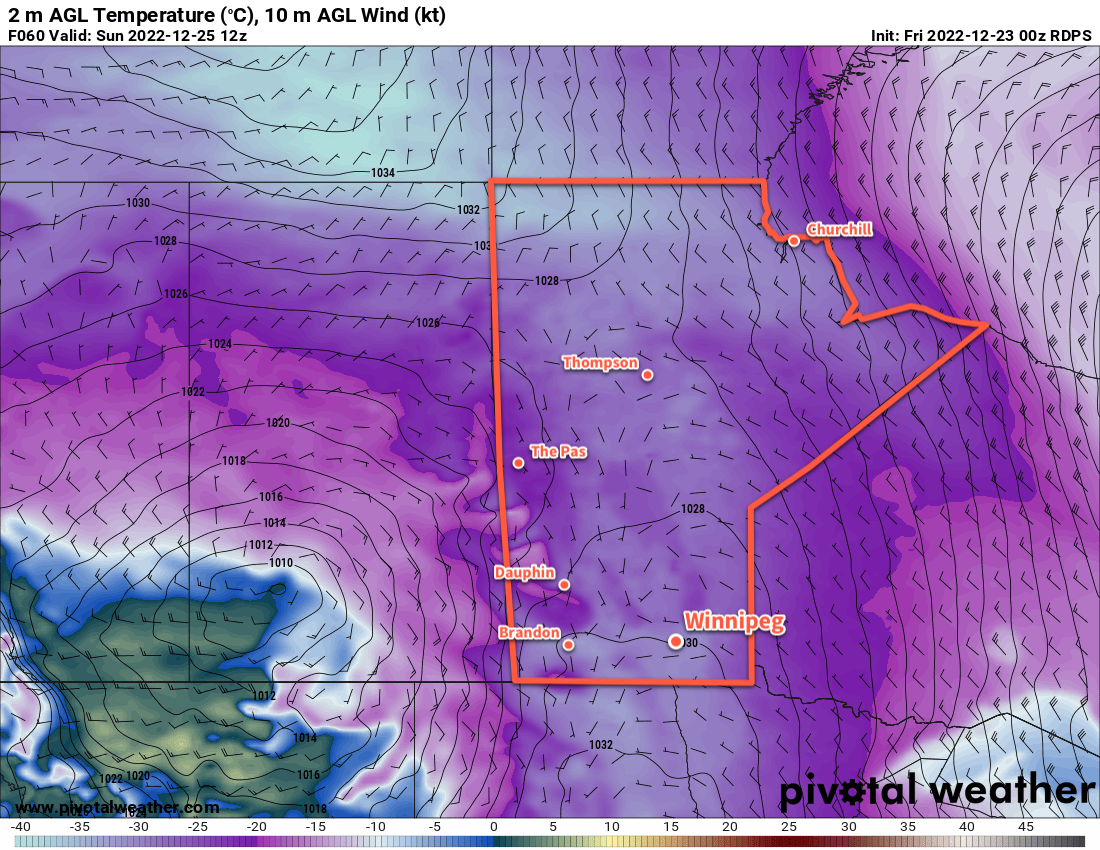
On Sunday, some cloud will push into the region as a disturbance dives through the region. Snow will push through western portions of the province, likely staying west of the Red River Valley as it struggles against the colder air. Temperatures will climb into the mid-minus teens with light winds, making for a relatively pleasant Christmas Day afternoon across southern Manitoba. Temperatures will dip into the -20 to -25 °C range on Sunday night.

Long Range Outlook

The Arctic air will lose its grip on the region as next week progresses with daytime highs climbing close to -5 °C by mid-week. 

Some light snow will accompany the warm-up; on Tuesday night, a band of 5 to 10 cm is likely across WestMan and the Interlake with lesser amounts near 2–4 cm in Winnipeg. If this system ends up a bit further south, the main band of snow could end up falling along the Trans-Canada Highway corridor.

The milder weather will last for the rest of the week, then slid back towards seasonal values to start off the new year. Happy holidays!

Today’s seasonal daytime high in Winnipeg is -12 °C while the seasonal overnight low is -22 °C.

Light Snow Lingers Into the Weekend

Temperatures will cool through the weekend as light snow lingers on the back-side of the departing Colorado Low.

RDPS 24hr. Snowfall Accumulation Forecast valid 00Z Sunday December 18, 2022
Light snow will continue to fall over the next couple days in southern Manitoba. Accumulations will be relatively light, though, with only 2 to 5 cm likely by Saturday evening.

The Colorado Low that brought accumulating snow to the region over the past few days is gradually trundling eastwards, but its slow departure will mean both gradual cooling and lingering snow. In Winnipeg, this means cloudy conditions with periods of light snow over the next few days.

Accumulations will be relatively light over the next few days at just a couple centimetres or so each day. But with cooling temperatures, the persistent north wind and drier snow will result in plenty of blowing and drifting snow.

Temperatures will slide to around -10 °C this afternoon, then continue to drop over the next day. Expect lows around -12 °C tonight, then temperatures continue to slide into the mid-minus teens on Saturday.

Temperatures will stabilize for Sunday into Monday at seasonably cool values, but there will continue to be a chance of light snow.

Long Range Outlook

Heading into next week, a major pattern change is underway across the Prairies. A lobe of the Polar Vortex will detach and slump into the Prairies, bringing with it much colder temperatures. Beginning early next week, temperatures in southern Manitoba will begin to plummet. Daytime highs will fall into the -20s with overnight lows dipping close to -30 °C.

That stretch of colder weather will likely last much of the week, but some moderation back towards seasonal temperatures looks to be in store by the weekend.

At least we should see the sun more next week!

Today’s seasonal daytime high in Winnipeg is -10 °C while the seasonal overnight low is -20 °C.

Unpleasant Blast of Winter Weather Arrives

Strong northwest winds will send temperatures plummeting in Winnipeg today.

RDPS 2m Temperature Forecast valid 12Z Saturday December 3, 2022
A very cold air mass will move over the entire Prairies today with temperatures ranging from -20 to -35 °C across the region by Saturday morning.

A disturbance that brought snow to parts of western Manitoba will bring about quite a pattern chance for Winnipeg today. As the system tracks off to the east, moderate to strong northwest winds will develop and draw colder Arctic air into the region.

In Winnipeg, winds will increase to around 40 gusting 60 km/h midday, while to the west and south of the city the winds will be stronger, reaching as high as 50 gusting 70 km/h. These winds will send temperatures falling from around -11 °C this morning to around -18 °C by the evening. Wind chill values will become an issue later in the day, falling into the -30s by late afternoon.

The winds will also produce blowing snow through the Red River Valley, but the worst hit area will likely be the Trans-Canada Highway corridor between Elie and Portage la Prairie. If travelling through that area today, be prepared for the potential for road closures due to poor driving conditions this afternoon.

The wind will ease this evening with clearing skies. Temperatures will dip to a low around -23 °C.

A ridge of high pressure will move across the region on Saturday, keeping skies clear and temperatures cold. Winnipeg will see temperatures climb to a high near -15 °C with a southwest wind near 20 km/h. Temperatures will dip to a low near -20 °C tonight with increasing cloud towards Sunday morning.

On Sunday, a low pressure system will move through the region, dropping from northern Saskatchewan into the Interlake. It will bring warmer temperatures back to the region with highs into the -5 to -10 °C range along with some light snow. The north winds will return on Sunday night, sending temperatures downwards through the day on Monday.

Long Range Outlook

Arctic air returns early next week, bringing some of the coldest temperatures Winnipeg’s seen so far this winter. Temperatures will likely drop towards the -20 °C mark on Monday, then continue into the mid-minus twenties on Monday night. Tuesday could be the first day of the season with a daytime high colder than -20 °C, but temperatures then look to gradually moderate through the remainder of the week.

Today’s seasonal daytime high in Winnipeg is -6 °C while the seasonal overnight low is -13 °C.

#awm #forecast_post #awm_windy #awm_blowing_snow

Spring Fights Its Way Towards Southern Manitoba

The winter that seemingly never ends continues in southern Manitoba, but more snow may actually mark a shift towards spring-like conditions.

RDPS 24hr. Snow Accumulation Forecast valid 06Z Sunday March 13, 2022
Another low pressure system will bring a swath of 5 cm of snow across Southern Manitoba on Saturday.

Long-suffering Winnipeggers, buried under feet of snow and frozen to the core by a second half of winter largely marked by below seasonal temperatures frequently plummeting below -30 °C, have plenty of reason to look at the forecast with suspicion. Hopes for spring have been dashed several times already this year as long-range warmth is crushed by yet another Arctic High descending from the north.

But…

Major Change is afoot. The polar vortex, anchored near Baffin Island the past while, will soon shunt northeastwards over Greenland. As it leaves, it will take the cold trough responsible for the persistent cold in our region with it. This will allow a moderating westerly flow to develop over the Prairies. As a result, the region should see a return to much closer to seasonal temperatures in the coming week. There’s a good amount of confidence with this larger-scale pattern change, too!

But, before we get that far, there’s the weekend weather to consider. This morning sees the region in the wake of yet another Alberta Clipper, complete with cold conditions, strong northwesterly winds, and another closure of Winnipeg’s Perimeter Highway. These conditions will last into the afternoon before winds begin to ease. The day will bring a few afternoon clouds, but it’ll stay cool with a high in the mid-minus teens. Tonight will be clear and cold with a low near -25 °C.

Another low pressure system will begin moving from northern Alberta towards the Manitoba Lakes on Saturday. As its warm front approaches the region in the morning, it will bring increasing cloud as southerly winds strengthen. Blowing snow will develop over the region midday, then conditions will deteriorate mid-afternoon as snow moves into the region. Travel conditions will likely be poor between noon and 9 PM on Saturday. The snow will taper off overnight with 3–5 cm likely through most of the Red River Valley.

This system will, in addition to the wind and snow, bring warmer temperatures into the region. Temperatures will climb to the warm side of -10 °C by Saturday evening. Temperatures will continue to warm into the 0 to -5 °C range through the evening hours. The region will see a low a bit below -10 °C by Sunday morning.

Sunday marks the beginning of daylight savings time, so don’t forget to spring your clocks forward and hour!

Sunshine returns to the region on Sunday with easing northwest winds and a high in the -5 to -10 °C range. Temperatures will cool to the mid-minus teens on Sunday night with light winds a partly cloudy skies.

Long Range Outlook

Next week will mark the transition towards warmer weather, but how warm it gets will be limited by the immense snowpack over southern Manitoba. Temperatures will climb into the -5 to -10 °C range on Monday, followed by a warm frontal passage on Monday night. This will mark the start of a push of milder Pacific air into the region.

RDPS 2m Temperature Forecast valid 21Z Monday March 14, 2022
A surge of much warmer, spring-like temperatures will begin building across the Prairies on Monday.

Forecast daytime highs for Tuesday through Saturday all sit above freezing; anywhere from 2 to 4 °C above zero. Those temperatures might be tricky to reach without a strong wind keeping the lower atmosphere well-mixed. More likely, the region will see temperatures up to a couple degrees above 0°C. Temperatures warmer than that will be tied to areas with less snow or more exposed concrete (e.g. downtown Winnipeg may see slightly warmer temperatures).

The warmer temperatures will begin melting the snow pack over the region. With dew point values staying at or below freezing, no unusually rapid melt is expected. The warm air combined with the widespread snowpack should result in quite a bit of cloud cover through the week. More sun is possible if southwest or westerly winds develop, helping mix drier air into the Red River Valley.

While we’ve seen plenty of broken spring promises so far this year, it looks like a near-certainty that southern Manitoba will finally see some relief from the cold begin next week.

Today’s seasonal daytime high in Winnipeg is -2 °C while the seasonal overnight low is -12 °C.