Winnipeg will see seasonably mild conditions over the next several days with an abundance of cloud cover.
Winnipeg will see the light snow that moved into the region yesterday persist for a few more hours this morning before tapering off. Cloudy skies will remain as temperatures climb to a high near +2°C this afternoon. Winds will stay light through the day. Tonight will bring more cloudy skies with temperatures dipping to a low near -3°C.
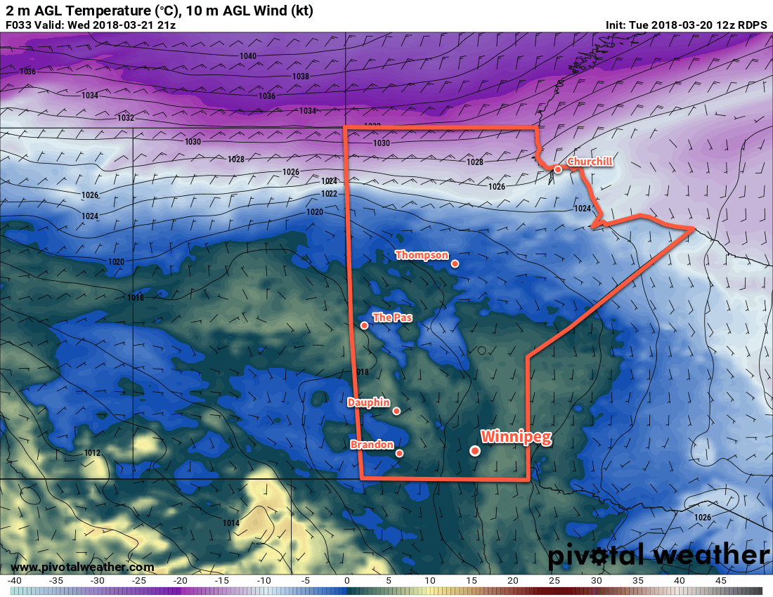
Temperatures will climb above 0°C across much of southern Manitoba on Wednesday
With a stagnant pattern in place over Winnipeg on Thursday, the city see similar conditions to Wednesday. Under mostly cloudy skies, temperatures will climb to a high near +3°C with light winds. There may be a few clear patches on Thursday night as temperatures dip to a low near -3°C again. Winds will increase to around 15 km/h by Friday morning.
A more organized disturbance will begin working its way towards Winnipeg on Friday as a large Pacific storm system begins pushing inland. Winnipeg will see mostly cloudy skies with a high near +3°C yet again. Winds, however, will be a bit more noticeable out of the east-southeast near 20 km/h. By late in the day, an area of snow will begin spreading across southwestern Manitoba into the Red River Valley. Winnipeg will likely see a couple cm of snow on Friday night as temperatures drop to a low near -2°C.
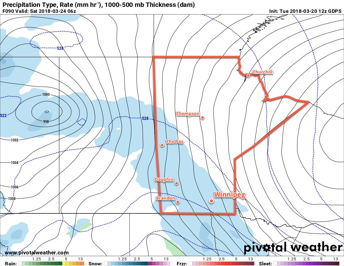
Snow is forecast to spread across southern Manitoba on Friday night
Long Range Outlook
Looking ahead to the weekend, Winnipeg will see more of the same with cloudy skies, highs near +3°C, and lows dipping just below freezing. Snow should taper off Saturday morning, then a more significant snowfall of 4 to 8 cm is forecast to move into the region on Sunday.
This second batch of snow is forecast to taper off on Sunday night, followed by gradual clearing in the Red River Valley through the first half of next week. Temperatures will remain relatively mild with highs a few degrees above 0°C and lows dipping a few degrees below.
Winnipeg’s seasonal daytime high is currently 1°C while the seasonal overnight low is -9°C.
Seasonal temperatures will continue in Winnipeg this week, but with plenty of cloud and a bit of light snow.
Winnipeg will remain under cloudy to mostly cloudy skies for the next three days as a train of upper-level disturbances moves through the region. Temperatures will reach a high near -1°C under cloudy skies in Winnipeg today. Some light snow may develop in Winnipeg this afternoon as a weakling upper-level trough moves into Manitoba. The chance for light snow will continue tonight as temperatures dip down to a low near -7°C.
Tuesday will bring more cloudy skies to Winnipeg with a high near 0°C. The Red River Valley will continue to see a chance of light snow as the upper trough exits the province. All snow – if there is any – should taper off on Tuesday night as temperatures head to a low near -7°C.
Temperatures will climb above the freezing mark in Winnipeg on TuesdayWednesday will bring…more cloud to Winnipeg. Light winds over the coming 3 days will do very little to move the extensive area of cloud out of the region. So, under mostly cloudy skies Winnipeg should reach a high near +1 or +2°C. With more cloud around on Wednesday night, temperatures should dip to a low near -7°C yet again.
Long Range Outlook
Little change is forecast through the remainder of the week. Fairly cloudy conditions will remain in place, but temperatures will warm just a tad with highs climbing into the +3 to 5°C range. The weekend continues the cloudy prognosis, with increasing chances for light snow.
Winnipeg’s seasonal daytime high is currently 0°C while the seasonal overnight low is -10°C.
Although the second half of the week will see cooler temperatures than have been in place over the past 5 days, daytime highs will nonetheless still remain above the seasonal values near -2°C. Perhaps one of the biggest differences over the next few days will be that it will be significantly cloudier than seen over the past several days which will likely slow down the melting a little bit. Highs near or above 0°C will continue to keep the City of Winnipeg a slushy, sloppy mess, so don’t put away that spare bottle of windshield washer fluid yet!
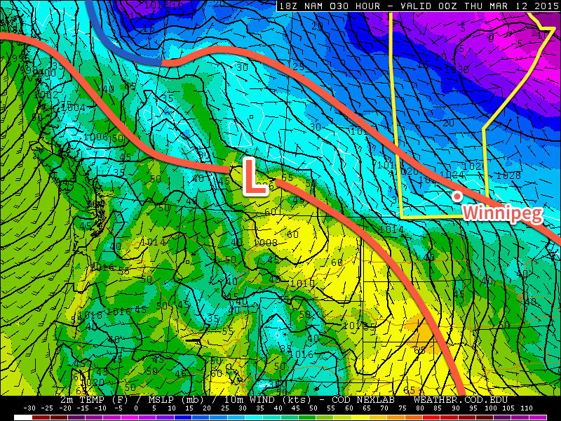
A low pressure system developing in Alberta & forecast to track eastwards across the Prairies will bring continued warm weather alongside plenty of cloud.
Today will be a mostly cloudy day in Winnipeg with a chance for some non-accumulating light flurries as a weak warm front(fn) slides northeastwards through the region. After the passage of the front, there may be a rogue sunny break, but overall skies should remain mostly cloudy as temperatures climb to near +1°C with an easterly breeze. Cloud cover will thicken up tonight as the main support for the advancing low from Alberta begins pushing towards our region. Skies will be overcast tonight with temperatures remaining steady near 0°C.
Wednesday
+1°C / ⇒ 0°C
Mainly cloudy with a chance of morning flurries
Thursday
5°C / -1°C
Cloudy; chance of evening showers or flurries
Friday
3°C / -2°C
Mainly cloudy
Thursday will be an overcast day through the Red River Valley with light winds as a low pressure system tracks right across the region. Temperatures will be warmer – highs should be near 5°C – and no precipitation is expected through much of the day. Heading into the evening, a chance for some showers or flurries will spread into the Red River Valley alongside northwesterly winds to 20-30km/h behind the passage of a trough. The chance for some flurries will persist through the overnight period as temperatures drop to around -2°C.
Friday will be another mainly cloudy day. A few light flurries may linger into the morning hours, but in general most of the day will see no precipitation. Highs will climb to near +3°C with a chance for some sunny breaks in the afternoon. Skies will clear through the evening as we head to a low near -2 or -3°C.
Near-Seasonal In The Long-Range
This weekend looks to bring another surge of warmth to Southern Manitoba on Sunday that will push daytime highs into the upper single-digits, but looking further than that, near-seasonal temperatures are expected. This translates to daytime highs around the 0°C mark or so. The odd day here or there of slightly warmer-than-normal is possible, but all in all it appears that Winnipeg will be transitioning into a fairly dry, seasonal March pattern next week.
Fortunately, with daytime highs above 0°C many days and little snow expected, the erosion of the snowpack in the Red River Valley will continue over the coming week. With little snow expected, many regions in the valley could see snow-free conditions by the end of the weekend. This is particularly significant as areas of snow-free ground will warm up significantly more than snow-covered ground. As we head into the coming weeks and warmer and warmer air begins moving in, it won’t be uncommon to see 10°C temperature differences over short distances based solely on snow-cover.
After the bone-chilling February experienced in Winnipeg, there are no complaints to be had with how March has unfolded so far and looks to continue!
Mild temperatures, above seasonal for this time of year, will be in place over Southern Manitoba, but the potential warmth will be limited over much of the Red River Valley and areas east thanks to an extensive area of low cloud that has moved into Manitoba and North Dakota within the outflow from a ridge of high pressure situated over Michigan.
Wednesday
-2°C / -3°C
Mainly cloudy & windy.
Thursday
0°C / -2°C
Mostly cloudy and mild
Friday
+1°C / 0°C
Mixed skies and mild
Today will be 7-8°C above seasonal for this time of year[1] with temperatures climbing to the -2 to -1°C mark by late this afternoon under cloudy skies. It will be moderately windy too with sustained wind speeds in the 30-40km/h range with gusts up to around 50km/h, making it feel like a much cooler day than it actually will be.
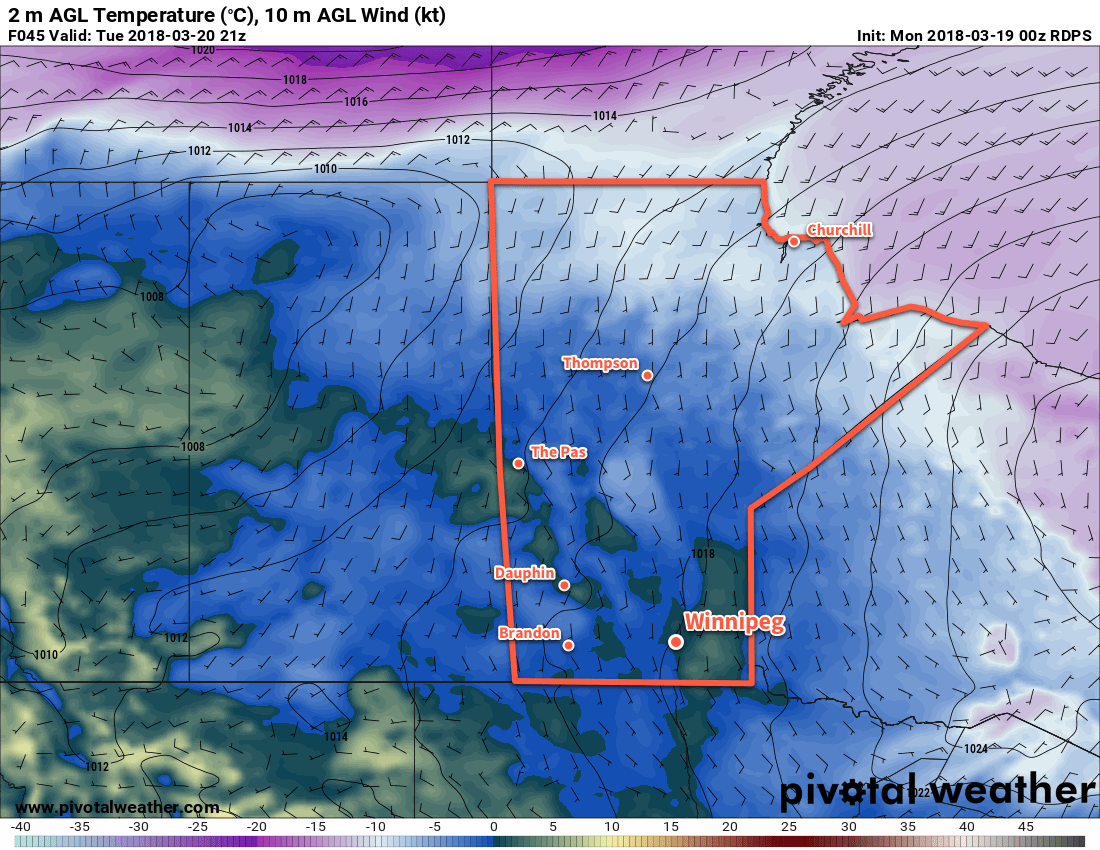
As the jet stream lifts northwards, warmer air lifts northwards as well.
The warming temperatures are thanks to a large upper-level ridge moving into the region which will develop an increasingly southwesterly flow across the Prairies and shift the jet stream further north. These two things together are helping push mild Pacific air into the southern Prairies. Unfortunately for Winnipeg, a ridge of high pressure anchored over Michigan will result in a persistent flow of colder air near the surface which, coupled with the cloud cover, will result in temperatures much lower than will be seen further west where a combination of more sun, terrain and some slightly more favourable wind directions will push temperatures towards record high territory.
Temperatures will barely drop tonight, perhaps just a degree or two, with winds tapering off to around 20km/h. The cloud cover will possible break up a little bit, but will likely remain cloudier than not.
Thursday will likely be another mostly cloudy day as the stratus continues to limit our daytime highs. We should see the temperature climb up to around 0°C with the southerly winds near 20km/h diminishing to light through the day. Thursday night will bring some scattering of the clouds, although mixed skies persisting until morning is the most likely situation at this point. Indications right now show that there may be a slight risk for freezing drizzle on Thursday night. Expect a low near -2°C.
Friday will be the nicest day of the three with a little sunshine looking a bit more likely than today or tomorrow. Temperatures will likely climb up to around 0 or +1°C, however if we end up with substantial amounts of sunshine, +2 or +3°C may even be possible.
Much Warmer over Western Manitoba
For areas in Western Manitoba, especially those on the northern side of the Turtle Mountains or those in the Dauphin area near the Riding Mountains, temperatures will be quite a bit warmer over the coming days. A combination of several factors, including:
Further proximity from the ridge over Michigan will minimize the amount of cold air being reinforced near the surface in a return flow.
Winds have a more southerly to slightly southwesterly component which will help tap the warmer air.
Terrain is not a valley that likes to keep cold air caught in it.
Downslope mixing on the northern side of larger terrain features will help couple the surface and warm air aloft.
This all means that for several days, beginning today, daytime highs will generally climb into the +2 to 5°C range for areas in the more generally open area to warmer values of +5 to +8 in regions downwind (north of) major terrain features such as the Riding Mountains or Turtle Mountains.
Warmth Spreads into the Red River Valley on the Weekend
The even warmer weather will spread into the Red River Valley for the weekend, however, as winds shift into a more southwesterly flow, helping push out the cold air and get some of that more substantial warmth into the region. Saturday looks to bring highs in the low-to-mid single digits with cooler air filtering in on Sunday, dropping highs back to the cooler side of 0°C alongside a chance for some light snow.
The seasonal daytime high for Winnipeg this time of year is around -9°C. ↩