First Taste of Winter

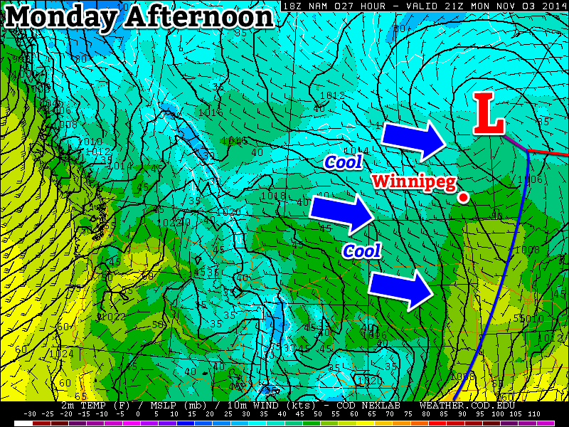
This week will feature our first taste of winter as a cold arctic air mass descends on southern Manitoba.

Cold weather will descend on southern Manitoba this week

Monday

Monday
-5°C / -8°C
Mainly cloudy with chance of flurries

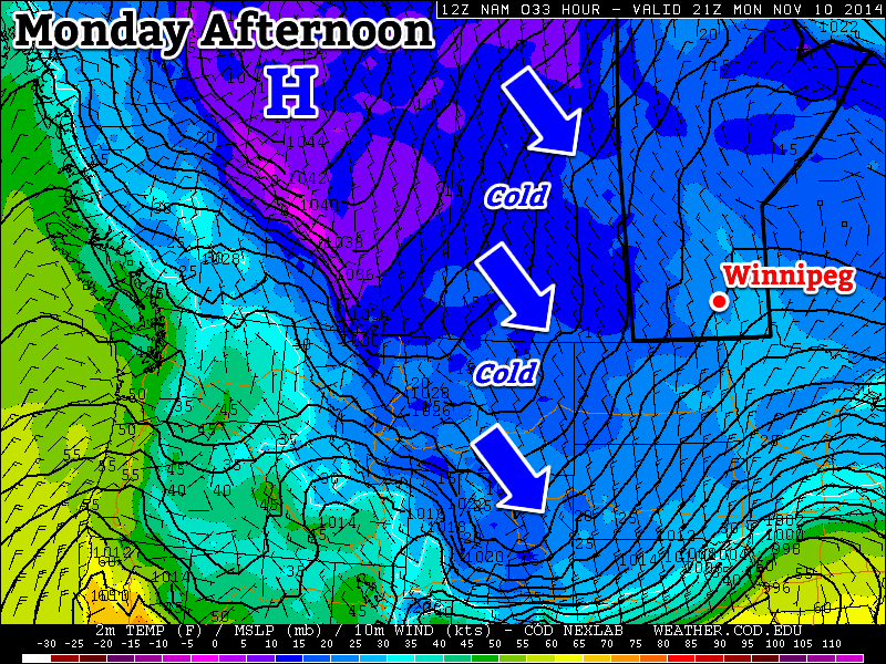
Today will be one of the coldest days we’ve seen so far this fall. High temperatures will stay on the minus side of zero with the possibility of light flurries throughout the day. There will be a breezy north wind as well, but overall it shouldn’t be too unpleasant.

Tuesday

Tuesday
-4°C / -5°C
Mainly cloudy with chance of flurries

Tuesday will feature weather that is very similar to that experienced on Monday. High temperatures will once again remain in the minus single digits with a chance of flurries. The wind will once again be from the north, at 20-30km/h.

Wednesday

Wednesday
-3°C / -6°C
Flurries

Sub-freezing weather will continue on Wednesday, with high temperatures in the minus single digits yet again. Flurries will be likely throughout the day, and some light accumulation may even occur. The wind will be gusty and from the north or north-west.

Long Range

The long range forecast suggests we will see wintry conditions continue for the foreseeable future. Thankfully, no major snowfall events are currently in the forecast. Snow cover dramatically affects our temperature regime, so the longer we can avoid the white stuff the longer we will avoid really cold conditions!

Warmer than Normal, but Still Cool

Conditions will remain at or above normal this week, unfortunately “normal” continues to get colder by the day.

A cool westerly flow will dominate southern Manitoba on Monday

A cool westerly flow will dominate southern Manitoba on Monday

Monday

Monday
8°C / 2°C
Mix of sun and cloud

Today will be mild by early November standards, but that doesn’t mean it will be warm. Temperatures will be in the mid to upper single digits in southern Manitoba with a brisk westerly wind. Skies will be a mixture of sun and cloud as an upper-level weather system moves across Manitoba.

Tuesday

Tuesday
4°C / 0°C
Mainly cloudy with chance of showers or flurries

Tuesday will be cooler than Monday as we see a brisk north-westerly flow behind a departing low pressure system. Temperatures will generally be in the mid single digits under mainly cloudy skies. There may be a few flurries or rain showers, but no significant accumulations are expected.

Wednesday

Wednesday
3°C / 1°C
Mainly cloudy with chance of showers/flurries

Wednesday will see continued cool weather in southern Manitoba with temperatures in the low to mid single digits, but lighter winds than what we saw earlier in the week. Skies will remain mainly cloudy and we may once again see some light flurries or rain showers.

Long Range

The long range forecast suggests we’ll continue to see normal to above-normal weather for at least the next week or so. Beyond that model solutions diverge, with equal chances of us ending up above or below normal.

Near Normal Weather to Start the Week

The beginning of this week will feature near normal weather which will be more the result of the normal high temperature dropping as opposed to the temperature rising.

Near normal weather is expected in southern Manitoba on Monday

Monday

Monday
18°C / 6°C
Mainly sunny

Today will feature temperatures in the mid to upper teens, which will actually make it one of the warmer days we’ve had lately. Skies will be mainly sunny and winds will be gusty and from the west. Overall, a cool, but pleasant day.

Tuesday

Tuesday
17°C / 6°C
Mainly cloudy

Tuesday will see the return of cloudier conditions. Temperatures will not decrease significantly from Monday’s values, but the lack of sun will make it feel a bit cooler. High temperatures will remain in the mid to upper teens with light winds.

Wednesday

Wednesday
15°C / 7°C
Mainly cloudy

Mainly cloudy conditions are expected once again on Wednesday. Temperatures will will remain in the mid teens and there will be a slight chance of showers.

Long Range

The long range forecast continues to hint at the return of warmer than normal weather by late this week or next weekend. It’s too early to say for sure, but there might be one more stretch of summer weather in our future before fall really hits.

Melt to Continue

Melt weather will continue this week, giving our snowpack a well deserved beating.

Warm weather will dominate southern Canada on Monday

Monday

Monday
4°C / -5°C
Mainly Cloudy

Today will feature temperatures similar to what we saw on the weekend. Highs will be in the mid single digits, although it will be a mainly cloudy day. The wind will be relatively light and from the west or north-west.

Tuesday

Tuesday
6°C / -1°C
Mainly Cloudy

Tuesday will be very similar to Monday is many respects. Skies will once again be mainly cloudy, but with an increasing southerly wind. High temperatures will once again be in the mid single digits.

Wednesday

Wednesday
10°C / -2°C
Mix of Sun and Cloud

Wednesday looks to be one of the warmest days of the week. An approaching low pressure system will push a warm air mass into southern Manitoba, potentially sending temperatures soaring into the positive teens. Snow-free areas just to our south could be even warmer, with Grand Forks and Fargo potentially having a shot at reaching 20C for the first time this year.

Long Range

We’ll see a slight cool down after Wednesday, with temperatures on Thursday dropping back down into the single digits. Models suggest that we’ll generally see below-normal conditions through the middle of the month, but thankfully that just means temperatures will be lower than +10C, which won’t really feel that cold in general.