Mild Weather Gives Way to Blustery Cold Front

The warmer-than-seasonal warmth in place over Southern Manitoba will last just one more day before a cooler air mass works its way into the region behind a cold front that will push through on Thursday.

Today will bring seasonal weather to Winnipeg & the Red River Valley, albeit with a bit of a breezy wind. Under mainly sunny skies, the temperature will climb to around 15°C, which is nearly 5°C above the seasonal average high of 11°C for this time of year. Winds will pick up through the day and be fairly windy out of the northwest with sustained winds climbing to 30–40km/h with gusts to around 50km/h.

Temperatures will dip to around 4–5°C tonight with skies becoming partly cloudy before morning.

Thursday will be quite an unpleasant day that will see a cold frontal passage that will bring in blustery winds and falling temperatures. The day will start off with partly cloudy skies and temperatures climbing to around 10–11°C by midday. Winds will be windy out of the northwest at around 30km/h with some gustiness on top of that. As the cold front passes through in the afternoon, we’ll see mixed-to-cloudy skies develop with a very slight chance of some showers along the front as it passes through. No significant accumulations are expected. Winds will remain blustery with winds remaining at 30–40km/h with gusts as high as 60km/h.
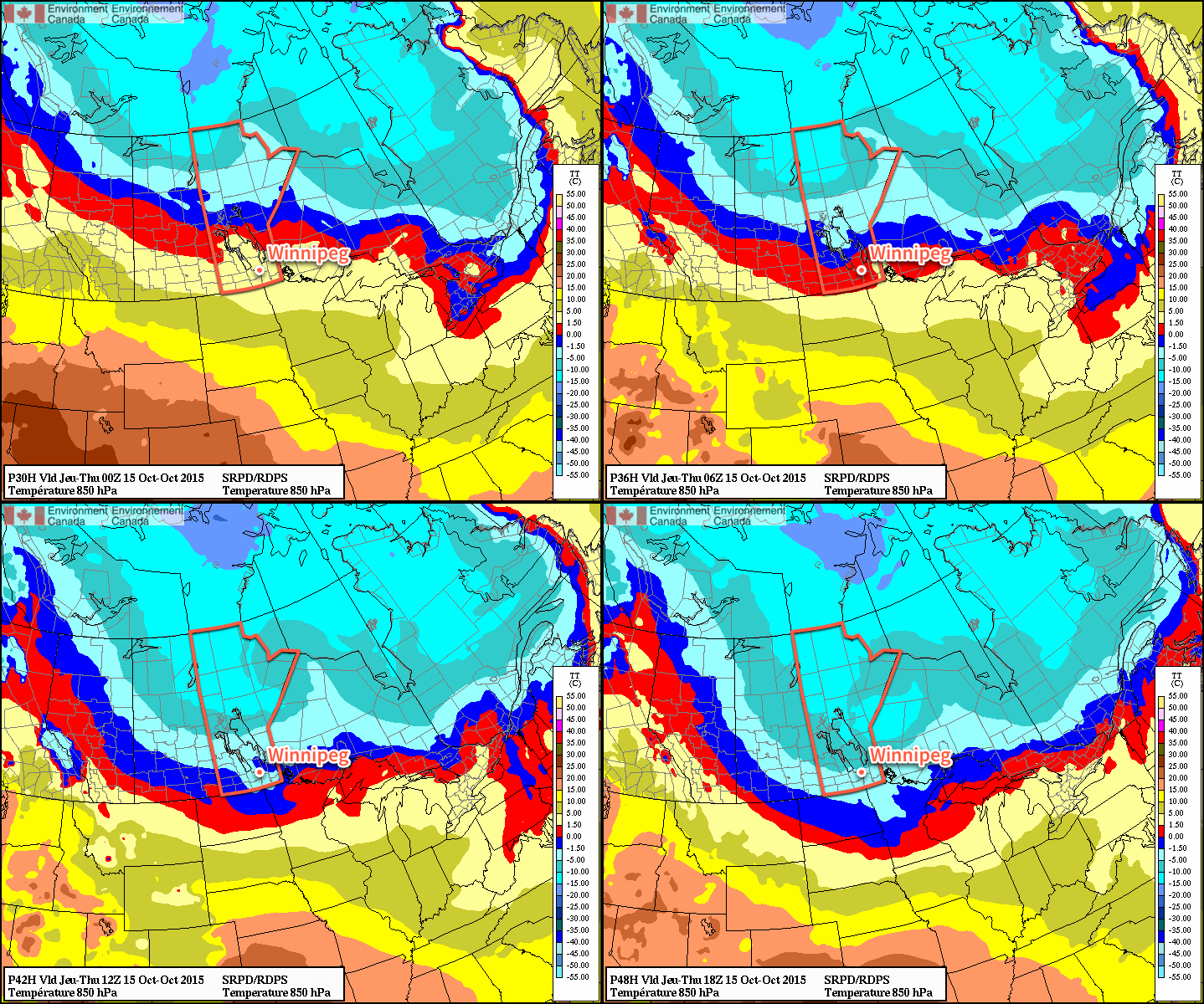
Animated 850mb Temperature Forecast for Thursday
Looking at the forecast 850mb temperatures, the passage of the cold front on Thursday is quite obvious.

As the front passes through, temperatures will drop to around 6°C in the Red River Valley. They’ll continue to drop as winds taper off and skies clear, heading towards an overnight low near –2°C.

Friday will be a pleasant, but cool, day. Winds won’t be much of an issue and temperatures will climb to around 7°C under mainly sunny skies. The low on Friday night will once again be around –2°C under clear skies.

Unremarkable Weekend Ahead

Looking ahead to the weekend, there doesn’t appear to be much to say about it. Through the weekend temperatures will climb back towards seasonal values with a bit of wind on Sunday. No significant precipitation is in store for the region.

Next week looks to have a bit of variability to daytime highs and a couple chances for rain as a slightly more unsettled pattern develops.
Thunderstorms Return to Southern Manitoba

Showers and thunderstorms will make a return to Winnipeg & the Red River Valley today as a cold front sweeping southwards across the province moves through later this afternoon.

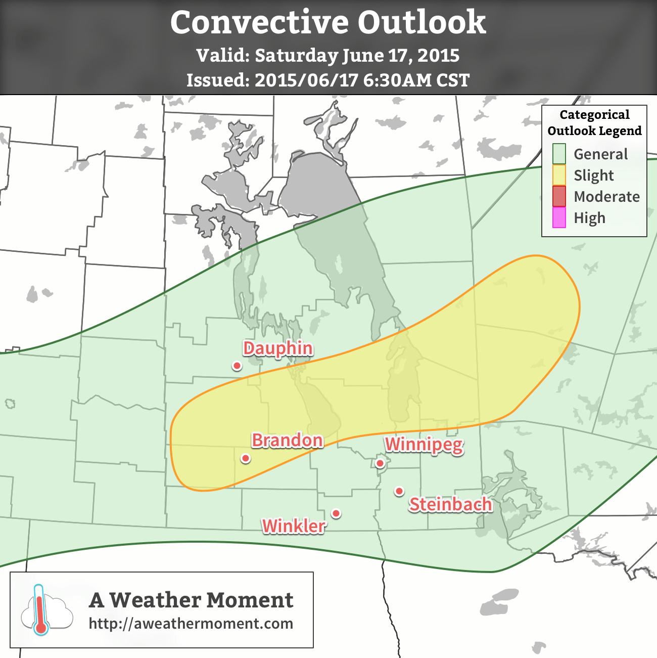
AWM Convective Outlook for June 17, 2015
A slight risk of severe thunderstorms is expected over Parkland Manitoba eastwards through the Interlake. A general risk of thunderstorms exists throughout the Red River Valley including Winnipeg.

Wednesday

Wednesday
24°C / 9°C
Afternoon showers or thunderstorms

Today will be quite a pleasant day until the front arrives; temperatures should climb to around 24°C before the front swings through with gusty winds out of the southwest at 30km/h.

The cold front will work its way through the Red River Valley from around 4 to 8PM, with a fairly large band of showers and thunderstorms along it. The thunderstorm threat doesn’t look too severe, however. Using the MIST principles:

  • Moisture: Dewpoint values will be fairly limited today with little moisture transport taking place, leaving and moisture accumulation to relatively local effects. Some moisture pooling ahead of the front should allow surface dewpoints to climb to 13–14°C, however the moisture will be quite limited in its vertical extent.
  • Instability: Overall instability looks sufficient for thunderstorms, but within that context, fairly marginal. Surface-based CAPE values will be around 1000 J/kg, however due to that shallow layer of moisture, mixed-layer CAPE values will be around half that.
  • Shear: Actually quite favourable! Around 30–40 kt of 0–6km bulk shear is expected primarily through speed shear, which should provide adequate support for the development of thunderstorms.
  • Trigger: This is perhaps the most favourable component of the whole day: the cold front is quite potent. Strong convergence will be in place along the front, providing ample forcing for the development and sustainment of thunderstorms.

In general, we’ll likely see a fairly widespread band of showers and thunderstorms develop along a line from SW Manitoba northeastwards through the Interlake early in the afternoon, then see it slowly progress to the SE through the rest of the day.

The main threats from the storms will be strong winds and heavy rain. The wind threat will come from fairly strong winds aloft coupled with fairly dry low-levels that may aid in evaporative cooling of downdrafts. The heavy rain threat will come from winds aligned prominently in parallel with the cold front, which may result in slow-moving storms that are able to remain in place a bit longer than usual. Marginally severe hail may be possible, however would likely be confined to the slight risk area outlined above.

Skies will clear behind the frontal system with northwesterly winds of 30 gusting 50 km/h or so tapering off as temperature drops to 9°C overnight.

Thursday

Thursday
20°C / 10°C
Mainly sunny

Thursday will be a cooler day with benign weather as a ridge of high pressure moves over the region. Daytime highs will sit near the 20°C mark with light winds under mainly sunny skies.

Friday

Friday
22°C / 15°C
Rain likely

The weather will head back towards unsettled on Friday as a disturbance moves along the US border sustaining an area of elevated convection ahead of it. Given that it’s convective in nature and a couple days out, there’s a moderate amount of uncertainty associated with this forecast, but at this point it looks quite likely that we’ll see an area of rain move through Southern Manitoba through the day on Friday. Rainfall amounts will be highly variable, and we’ll try to pin down more precise amounts closer to, with generally speaking anywhere from 10–15mm to 50+ mm if more intense convection manages to become embedded within.

Expect highs near 22°C or so with an overnight low in the mid-teens under partly cloudy skies.

Unsettled Weekend Ahead

The weekend looks potentially unsettled with multiple chances for showers or thunderstorms through Monday. Uncertainty is fairly high this far out, but for now the best bet is to expect mixed skies with a chance for some wet weather while highs sit in the low-to-mid 20’s.

Shot of Cold Air Incoming

The mild, dry weather we’ve experienced over the past week and a half continues for a couple more days before a powerful cold front sweeps through Southern Manitoba on Thursday night, bringing much colder temperatures to the region. Fortunately, the cool-down is expected to be short-lived with temperatures returning to seasonal values by the end of the weekend.

Wednesday
7°C / -3°C
Mainly sunny

Thursday
8°C / -8°C
Partly cloudy

Friday
-4°C / -15°C
Mainly sunny & breezy

Today will be another beautiful day with a high near 7 or 8°C, light winds and just a bit of cloudiness. Temperatures will drop to around –3°C tonight with light southerlies and mainly clear skies. Tomorrow looks quite nice as well with partly cloudy skies and a high near 8°C. Unfortunately, a big change is swinging through on Thursday night.

A potent cold front will swing through Winnipeg & the Red River Valley overnight Thursday, bringing with it a chance for some flurries and much cooler air. Winds won’t be too bad through Thursday night, perhaps to around 20km/h or so. Expect a low somewhere in the –8 to –10°C range.

Much cooler weather will persist through Friday and Saturday. Friday will be quite an unpleasant day as northerlies strengthen through the day to around 30–40km/h by late afternoon. The temperature will only climb to around –4°C for a high which will make it the coldest day since March 6th when the mercury topped out at +0.8°C. Temperatures will plummet into the mid-minus teens on Friday night as those strong northerlies really tap into the colder Arctic air plunging southwards.

Cool, Dry Weekend Ahead

This coming weekend will be dry and generally cool as a ridge of Arctic high pressure dominates the weather over the Red River Valley. Saturday will see highs near –6°C or so while the high on Sunday manages to climb back up towards the 0°C mark.

Record Snow Pack Loss

As of Sunday (March 15th, 2015), Winnipeg’s snow pack officially fell to 0cm. This was thanks to a dramatic melt that took much of Southern Manitoba from snow-covered to bare ground in just a few days thanks to a surge of record-setting warm air.[1]

MODIS imagery revealing significant snow pack melt in Southern Manitoba
MODIS satellite imagery reveals the dramatic melting of the snow pack over much of Southern Manitoba in under a week.

A snow depth of 0cm on March 15th ties for the 3rd earliest snow melt on record since 1955, trailing 2012 by just one day:

Top 11 Earliest Snow Melts (1955 – Present)
Rank Date of 0cm Snow Depth Year(s)
1 February 28 2000
2 March 14 2012
3 March 15 1995, 2015
5 March 17 1981
6 March 18 1973, 2010
8 March 21 1994, 1999
10 March 26 1961, 1984

The early melt was icing on the cake for Winnipeggers wary of a repeat of the never-ending winter of 2013/14. The winter of 2014/15 was effectively 4 months long – from mid-November to mid-March – of which 2 months of it was unseasonably mild. Not bad at all.


  1. On Saturday March 14th, 9 communities in Manitoba set record highs: Winnipeg, Portage la Prairie, Gretna, Dauphin, Brandon, Melita, Pilot Mound, Pinawa, and Sprague.  ↩

Cooling Down for Awhile

Conditions will cool down this week, but temperatures won’t stray that far from normal.


A cold front will pass through southern Manitoba on Monday

Monday

Monday
10°C / 2°C
Mix of sun and cloud

Today will be a transition day as a cold front moves through southern Manitoba. The front won’t pass through in dramatic fashion, so you probably won’t even notice it. However, it will set up cooler weather for the next few days. Despite the passage of that front, temperatures today will remain above seasonal, with highs near 10C and light winds.

Tuesday

Tuesday
4°C / 0°C
Mainly cloudy with chance of showers or flurries

Tuesday will be a much cooler day in the wake of Monday’s cold front. High temperatures will be in the single digits with a breezy north-west wind. There may be some light showers or even gasp flurries during the day, but accumulations should be minimal.

Wednesday

Wednesday
5°C / -2°C
Mainly cloudy

Wednesday will remain on the cool side with temperatures remaining in the single digits. No precipitation is expected, but skies will likely be mainly cloudy. The wind will be light and from the south or south-east.

Long Range

The long range forecast continues to look good. The NAEFS suggests that above-normal weather will persist into November. So far there is no sign of any significant snowfall in the forecast, which is always a good thing!