Cold and Calm

This week will start out cold and fairly benign. Our next chance for snow will come midweek.
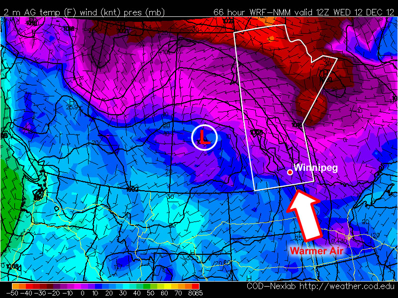
Warmer air will be advected into Southern Manitoba on Tuesday night

Warmer air will be advected (moved in via wind) into Southern Manitoba on Tuesday night

After another cold morning on Monday, temperatures will warm up a bit during the day. Highs on Monday afternoon should be in the low to mid minus teens, a significant improvement from Sunday’s minus twenties, but still chilly. The wind will be a bit breezy from the south on Monday, but wind chills values won’t be significantly colder than the air temperature (except in open areas). A weak low pressure system will pass through Southern Manitoba on Monday night, bringing some cloud cover along with it. As a result, temperatures on Monday night will be warmer than those on Monday morning as the cloud prevents heat from escaping from the surface. Unfortunately, temperatures won’t increase much on Tuesday, as we only see temperatures rise a few degrees from the morning lows. Our next little warm-up will begin Tuesday night as an approaching low develops a southerly flow over Southern Manitoba allowing temperatures to rise overnight.

As the low moves into (or just south of) Manitoba on Wednesday, it will bring our next chance for snow. At this point models suggest we may see as much as 5 to 10cm from this system, or perhaps as little as 2cm. Additionally, there are indications that we may see another weak system pass by on Thursday, bringing another small bought of snow. At this point it is too early to say how much snow to expect from these systems, but 5 to 10cm in total for both looks like a good initial “guess”. More information about the potential for snow will be available as the week progresses.
Weather Roller Coaster

This week will be a bit of a meteorological roller coaster as our temperatures climb up, then fall rapidly back down again.

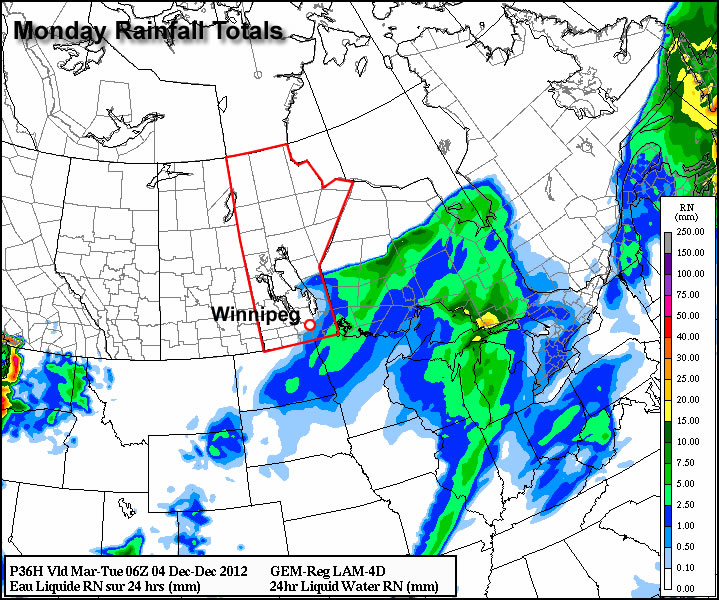
GEM-Regional predicted rainfall total for Monday

GEM-Regional predicted rainfall total for Monday

Monday looks to be the warmest day of the week with above freezing temperature of 1 or 2C expected in Southern Manitoba. Some light rainfall is expected in south-eastern parts of the province out ahead of a cold front. This may lead to icy conditions on Monday night as temperatures drop below zero behind the front. Winnipeg will be right on the edge of this area of rain, so the city isn’t expected to see more than a millimetre or two of rain at most. In fact most models take the area of rain just south-east of Winnipeg, so the northern part of the Red River Valley may end up with no precipitation at all. Temperatures will plummet on Monday night in the wake of the cold front with values dipping down into the minus double digits by Tuesday morning.

High temperatures will remain down in the minus teens in Southern Manitoba on Wednesday, with most areas in the -11 to -14C range. A weather system emerging from the mountains in Alberta will develop a southerly flow over Manitoba on Tuesday night. As a result, Tuesday night will be characterized by increasing warm air advection, allowing for warmer air to filter into Southern Manitoba during the overnight period. We will continue to experience warming on Wednesday as a stiff south wind continues to bring in warmer air. Unfortunately, the wind will be very strong, making conditions much less comfortable than the temperature alone would indicate. Highs on Wednesday will be in the low to mid minus single digits in Southern Manitoba, but wind chills values will be in the -10 to -15 range due to the strong south wind.

Another cold front will move through on Wednesday night or Thursday, setting up a chilly end to the week. No significant precipitation is currently in the forecast for Southern Manitoba this week as the main storm track remains to our north and west.

Cold Start to the Week

This week will start off feeling a lot more like winter, as temperatures drop well below normal.

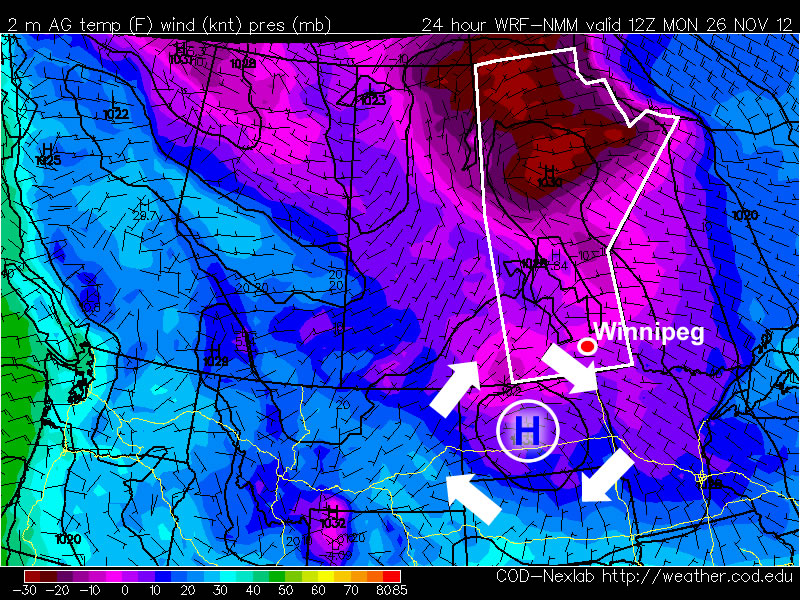
A high pressure system will bring cold conditions to Southern Manitoba on Monday

A high pressure system will bring cold conditions to Southern Manitoba on Monday

Temperatures this morning will be more like those you’d expect in late January, not late November. This morning’s cold temperatures will moderate somewhat by afternoon, with highs in the mid minus teens expected – not exactly November weather! Luckily some cloud cloud should move in during the afternoon hours, allowing Monday night to be significantly warmer than Monday morning. In fact temperatures may rise a bit on Monday night, up into the -6 to -10C range, in association with a weak low pressure system passing through. This low will bring a few flurries to Southern Manitoba overnight, with accumulations of no more than a centimetre or two expected. Unfortunately, another high pressure system will build in behind this passing low, bringing colder temperatures again for the daytime hours of Tuesday. Temperatures will begin falling back into the minus teens on Tuesday morning as cooler air spills in from the north-west. Tuesday night will be another cold one, with lows back down around the -20C mark. It looks like another small warm-up is on the way for Wednesday as yet another passing low pressure centre allows temperatures to climb back up into the minus single digits.

There remains some uncertainly in terms of how the late week period will play out. Models generally agree that we will stay below-normal for Thursday and Friday, but exactly how cold is not entirely clear. There have also been hints of a more active storm track setting up through Southern Manitoba from next weekend into the following week, something to watch as this week progresses.

A Mixed Bag

We’ll see some sun, some more snow, and temperatures all over the place as we see a wild weather pattern over the next few days.

12hr. QPF for Saturday

Precipitation accumulation for Saturday, showing some snow pushing through Southern Manitoba with greatest accumulations north and east of Winnipeg.

Sunshine will dominate today as a very strong Arctic high slumps through the Prairies. This high pressure system is a result of cold Arctic air pushing southwards behind a cold front that passed through yesterday. This will limit daytime highs today in the Red River Valley to only about -12°C. Temperatures will plummet towards -20°C tomorrow night as the ridge pushes through Southern Manitoba and breaks up remnant cloud left behind.

More cloud will begin pushing in late overnight into Saturday morning as another system tracks through the Northern Prairies. This system will warm things up a bit for us, bringing our daytime high on Saturday to a comparatively balmy temperature climbing just over -5°C. To go with those warmer temperatures will be some light snow with accumulations only around 2cm for much of the Red River Valley, including Winnipeg.

This system moves out on Saturday night, and we’ll move into a slightly more stable pattern. Sunday will likely be a mix of sun and cloud as we deal with a little bit of cloud left behind from Saturday’s system, with a high near -12°C again. As we head into next week, things look fairly steady with overnight lows near -15°C and daytime highs starting in the high minus teens and climbing into the low minus single digits.