New Year…Same Old News

Happy New Year! Hope you didn’t expect any significant shift in our weather pattern because the cold air is here to stay. A brief reprieve may be seen as a system slides through by week’s end, but the cold air is set to return behind it.

Wednesday

-27°C / -34°C
Mainly sunny; cold.
Thursday

-24°C / -26°C
Mainly sunny. Increasing cloud with a chance of light snow overnight.
Friday

-14°C / -25°C
Periods of light snow, 2-5cm. Clearing overnight.

We’ll see another very cold day today with any remaining clouds clearing out this morning as we march towards a daytime high of just –27°C or so. Temperatures will drop to around –34°C tonight under clear skies. Tomorrow will bring mainly sunny skies and slightly warmer temperatures as a system pushing eastwards into the Prairies begins bringing some slightly warmer air eastwards. Our high should reach around –24°C while the warmer air becomes much more apparent with our overnight low which will be comparatively balmy around –26°C. Clouds will push in overnight with a slight chance of some light snow before morning.

Snow Likely on Friday

Friday will likely bring light snow to Winnipeg as a low pressure system works through Manitoba. The bulk of the snow will through the Interlake into Central Manitoba, but we’ll likely see the white stuff here in the Red River Valley as well. It looks like most places will see around 2–4cm of snow, however it’s possible that we sneak into the 5–8cm range if things end up just a little heavier than currently forecast. At this point, it looks like Winnipeg would likely see 4–5cm of snow; we’ll be sure to update this if need be as the system gets closer.

A benefit to the cloud and snow will be warmer weather; temperatures should climb to around –14°C on Friday. Skies will clear overnight and we’ll drop down into the mid-minus twenties.

Cold Air Returns

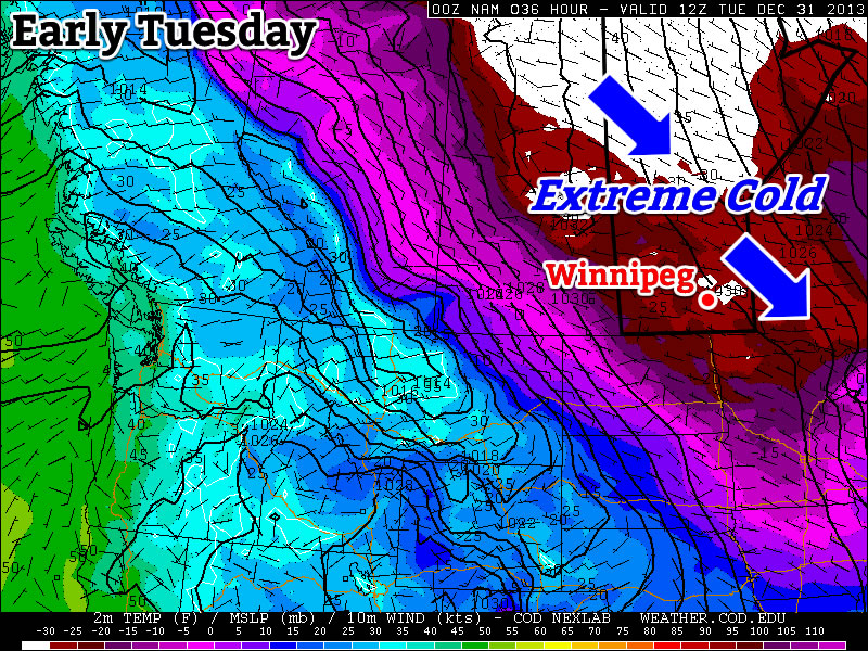
Yet another shot of extremely cold Arctic air is set to move back into Manitoba behind this system. Daytime highs will likely sit in the mid-minus 20’s through the weekend with overnight lows near –30°C, but the cold air should work it’s way into the region early next week, bringing another round of extremely cold temperatures.

2013 In Review

As it’s now 2014, I’ve already begun working on the 2013 statistics for Winnipeg. I hope to have a post ready within a couple weeks with a complete summary of the year past that will put into perspective where last year sat in the big picture!
Cold Enough for You?

December will end just as it began – COLD. The New Year will be ushered in by frigid temperatures, with no end in sight to the big cold.

”It

It will be extremely cold to start the week.

The Week Ahead

Monday

Mix of Sun and Cloud
-27°C / -37°C
Tuesday

Increasing Cloudiness
-28°C / -34°C
Wednesday

Clearing late
-23°C / -34°C

Monday

The Cold Poll Outcome
The cold poll outcome.

Today will be just another cold day. Luckily the wind won’t be particularly strong, though that’s little consolation. Tonight will be extremely cold, with low temperatures near -40C not out of the question in some traditional cold spots. It doesn’t look like Winnipeg will hit the -40C mark, but it could be close.

With extremely cold temperatures on the way tonight, take part and guess exactly how cold it’s going to get!

Tuesday

After a very cold start to the morning on Tuesday, it won’t warm up much. High temperatures are expected to remain near -30C, but winds will remain light as we languish under a strong surface high pressure system.

Wednesday

Temperatures may rise a bit from Tuesday evening into Wednesday morning as some cloud cover moves in. However, Wednesday will remain quite cold, with high temperatures still in the minus twenties. The wind will once again remain light, which about about the only good thing that can be said about the weather early this week.

Long Range

The long range outlook continues to look very ugly indeed. I have few positive things to say on this topic, so I’ll just leave it at that.

Alberta Clipper To Bring Snow and Extreme Cold

Conditions will change dramatically this weekend with no thanks to an Alberta clipper system that will spread snow into Southern Manitoba tonight and usher in extremely cold Arctic air1 to the region on it’s back side. Before that system arrives tonight, however, we’ll get to enjoy a beautiful day with temperatures climbing towards the 0°C mark!

Friday

-2°C / -18°C
Mostly cloudy and warm. Chance of an afternoon flurry. Snow beginning overnight.
Saturday

⇒ -18°C / -32°C
Snow. Windy with blowing snow. Cold.
Sunday

-26°C / -33°C
Mainly sunny. Very cold.

Today will be an exceedingly pleasant day for what has been a markedly cold December. Thanks to a flow of mild Pacific air brought in by westerly winds ahead of the Alberta clipper, we’ll see our temperature climb to around –3 or –2°C today with relatively light winds. Skies will likely remain mostly cloudy through much of the day with the cloud cover being bolstered by the warm temperatures over the snow and a weaker leading impulse tracking through the Interlake. We may see a few breaks in the cloud here or there, particularly through the mid-to-late afternoon period. Unfortunately, that’s where the good news ends. An Alberta clipper is on the way, and it’s a doozy.

Total new snowfall by Saturday evening. Anywhere from 5 to 15cm can be expected along the main frontal zone.

The system will begin spreading snow into the Red River Valley overnight along a line cutting across the northern Red River Valley. The heaviest band of snow will set up along the main frontal zone aloft which will be aligned roughly from Dauphin to Winnipeg and ESE into the Whiteshell. Underneath the heaviest band of snow around 5-10cm of snow can be expected by Saturday morning with amounts tapering to just 2-3cm near the US border. In addition to the snow, a cold front will begin to slump southwards late overnight which will usher in much cooler air. We’ll see temperatures drop to around –18°C with winds shifting out of the north.

Saturday

Saturday will be…miserable. Our temperature will remain steady near around –18°C as cold air continues to infiltrate into Southern Manitoba. Snow will persist through much of the day — although it will likely lighten to just a few flurries by the late afternoon — with another 2–5cm expected to fall across the Red River Valley which will bring storm-total snowfall amounts to around 5cm in areas on the fringes of the system track and anywhere from around 7–15cm under the heaviest band of snow. The winds will become more of an issue on Saturday as they increase out of north to 30–40km/h with gusts as high as 60km/h. These winds, aided by the fresh snowfall, will create areas of poor visibility in blowing snow, especially on any west-east running highways.

Please note: Driving conditions will likely be extremely poor on Saturday morning. In addition to the blowing snow, roads will likely be extremely slippery; the warm temperatures on Friday will likely produce moisture on road surfaces which will rapidly freeze overnight. On Saturday morning, roads will likely be icy with fresh snow on top and blowing snow on top of that. If you need to travel, carry a winter survival kit and give yourself lots of time to reach your destination.

The system will move out on Saturday night bringing clearing skies and extremely cold temperatures as an Arctic airmass settles over the region. Our overnight low will bottom out at about –32°C with fairly light winds.

Sunday

Sunday will be a mainly sunny but very cold day. The temperature will only recover to the low minus 20’s. Winds will remain light — little consolation given the temperatures, though. It’ll drop to around –33°C on Sunday night under clear skies.

When Will It End?

The latest NAEFS 8-14 day temperature outlook is calling for below-normal temperatures for Manitoba.
The latest NAEFS 8–14 day temperature outlook is calling for below-normal temperatures for Manitoba.

Unfortunately, all signs point to the cold weather sticking around for at least the next 4–7 days, if not longer. The NAEFS guidance shows below-normal temperatures expected in the 8–14 day range while all the shorter-range models show cold weather through the next week. The GFS is hinting at a system that might push through late next week that would bring slightly milder temperatures, but it would be short-lived and doesn’t look indicative of a pattern change.

It looks like we’ll definitely be closing out December 2013 as one of the Top 5 coldest Decembers on record in Winnipeg with little reprieve on the horizon. So go enjoy the last nice day of 2013 and then get your long johns ready, plug in the car, get a warm drink, fill up the hot water bottle, renew your CAA membership and whatever else you need to do to prepare for another prolonged bout of extreme cold.


  1. I’m doing my best to not use the phrase “bitterly cold” in today’s blog.  ↩

Mild, Snowy Christmas Eve Gives Way to Another Cold Snap

This week will see cold weather continue — not exactly the Christmas present that many were hoping for.

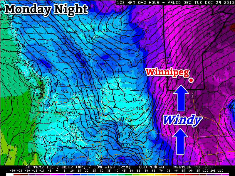
The Wind Will Pick Up on Monday Night

The Wind Will Pick Up on Monday Night

Monday

Monday

Sunny
-23°C / -25°C

After a frigid morning, temperatures won’t recover a whole lot today, but at least it will be sunny! Afternoon temperatures will be in the low to mid minus twenties, with increasing winds. Wind speeds during the morning and afternoon won’t be particularly high, but winds will increase through the evening and into the overnight period. Some blowing and drifting snow is likely in open areas on Monday night as winds increase to 30-40km/h gusting to 50-60km/h out of the south. To add insult to injury, snow is expected on Monday night into Tuesday. The snow will begin in Western Manitoba on Monday night, and push into the rest of Southern Manitoba by Tuesday morning.

Christmas Eve

Tuesday

Mainly cloudy. Snow.
-12°C / -20°C

Tuesday will be warmer than Monday as those stiff southerly winds overnight bring in some milder air, but this reprieve from the cold will be accompanied by snow. A total of 4-8cm of snow is expected in Southern Manitoba by the time the snow ends on Tuesday afternoon. Temperatures on Tuesday morning will be in the minus twenties, but by afternoon we should climb into the minus single digits over Western Manitoba and the mid minus teens over Eastern Manitoba. The Red River Valley will likely remain stuck in a southerly flow through the day, causing temperatures to remain a bit below -10C.

Christmas Day

Wednesday

Mainly cloudy. Chance of flurries.
-18°C / -28°C

Another cold front will pass through Southern Manitoba on Christmas morning, allowing cold weather to return for the big day. The wind will also pick up behind this front, generating chilly wind chill values. High temperatures for Christmas will be in the upper minus teens, with a chance of flurries through the day.

Long Range

The long range forecast looks cold, cold, cold. We may see one warmer day towards the end of the week, but other than that there is no moderation in the forecast.

$("").attr({
    "rel": "stylesheet",
    "href": "http://fonts.googleapis.com/css?family=Mountains+of+Christmas:700"
}).appendTo("head");
$("h1, h2, h3, h4, h5").css("font-family", "Mountains of Christmas");