Elsewhere in Weather News: March 30th, 2013

Europe Battles Cold

This past month it has not only been Southern Manitoba dealing with pesky cold Arctic air lingering around while the spring thaw should be starting up, most of Europe has also been under significantly below normal temperatures for the month of March. What has been bringing such cold weather can be attributed mostly to the same reason why we’ve been getting such cold; a negative NAO (North Atlantic Oscillation) pattern. This is cause for Scandanavian highs staying put and bringing down some unseasonably cold air from the north-east in Europe’s case.
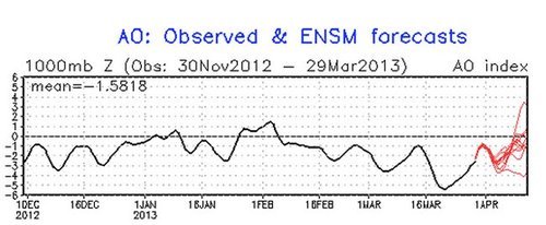
NAO

Graph of the NAO showing values of below zero for the whole month of March. (Source: NCEP)

Germany has had the worst of the cold in Europe with their average March temperature 4°C below average – the coldest ever since record keeping started in 1883. Other parts of Europe were generally 3°C below average for March. To add to the cold temperatures, Europe has been faced with a few significant snowstorms this month, such as last week’s snowstorm that caused hundreds of flight cancellations and even the closure of Frankfurt’s International Airport. The reason for these significant snow events this late in the season can be attributed to a low pressure system drawing in moist air from the North Mediterranean. This, when combined with the stationary Siberian high feeding cold air into the northern half of the low, makes for ideal snowy conditions.
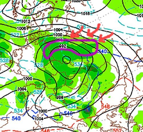
Low pressure system, Europe

Low pressure system making it’s way across Europe and bringing with it snow. Heavy snow in areas outlined in purple, thanks to cold air being brought down by the Scandanavian high.

The Scandanavian high looks to stay put over the region for just a little less than another week, however, with the NAO trending upwards and with the sun getting stronger every day (we are now at the equivalent of a September sun), this means that warmer temperatures are on the horizon for most of Europe for the second week of April.
Not a Great Start to the Week

This week hasn’t exactly started out on a pleasant note as you’re no doubt aware. Unfortunately, conditions won’t improve much after today.

image

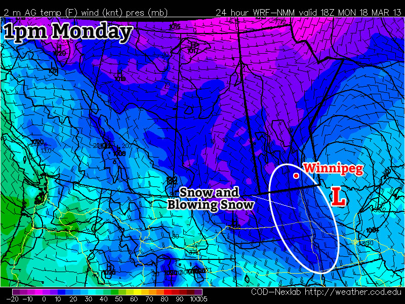
Predicted conditions early Monday afternoon (courtesy: College of Dupage NAM model)
Monday
image
Snow ending. Blowing snow.
-12°C / -21°C

Monday

Snow and heavy blowing snow is currently ongoing in parts of the Red River Valley. This snow and blowing snow will gradually taper off today, but not before snow totals of 10 to 20cm have piled up across Southern Manitoba. High temperatures today won’t be very pleasant, nor will low temperatures tonight. Overall a horrible start to the week.

Tuesday and Wednesday

Tuesday
image
Mainly cloudy
-12°C / -22°C
Wednesday
image
Mix of sun and cloud
-11°C / -21°C

Conditions on Tuesday will see little improvement from Monday. Highs will once again be very cold by March standards. Luckily no more precipitation is expected on Tuesday (except maybe a flurry here or there), which is at least something to be thankful for. Wednesday will again be a seasonably cold day, with no weather of note.

Long Range

The long range is…you guessed it, ugly. At this point the GFS model (a longer range model) doesn’t show us even getting to the freezing mark in the next ten days. While this may be an overly pessimistic forecast, it is certainly possible given the extensive snowpack over the Eastern Prairies. We can only hope it is wrong, and perhaps we’ll see at least some melting, however minimal, by the weekend.

Blizzard to Start the Week

Heavy blowing snow will greet residents of the Red River Valley on Monday morning. Calmer, but colder weather is in store after the storm passes.

NAM model predicted weather on Monday morning

Monday

Monday

Blowing snow
-18°C / -28°C

A strong low pressure system has generated heavy blowing snow and blizzard conditions in parts of the Red River Valley on Monday morning. Wind speeds early Monday are in the 40-50km/h gusting to 60-70km/h range across Southern Manitoba. This in combination with a fresh 5-15cm of snow in the region is the obvious cause of the very poor weather conditions. The wind will gradually taper off through the day on Monday, allowing the blizzard to subside as well. However, blowing snow at some level will last through basically the whole day in open country.

Tuesday

Tuesday

Mainly sunny
-22°C / -31°C

Tuesday will be a very cold day, in fact the coldest in quite awhile. Lows on Tuesday morning will be in the upper minus twenties, with highs in the low minus twenties. Wind chill values will be elevated as well, making for a rather unpleasant day.

Wednesday

Wednesday

Mainly sunny
-15°C / -20°C

Wednesday morning will be another cold one, with lows around minus thirty. Daytime highs will moderate somewhat, reaching into the minus teens. However, wind chill values will become an issue again on Wednesday afternoon, probably not what you were hoping to hear.

Long Range

There is no sign of spring in the long range forecast at the moment, but I do know that each passing day is in fact one day closer to spring, whether it feels that way or not.

The Deep Freeze Gives Way to A Mixed Weekend

While temperatures across the Red River Valley this morning are extremely cold, a developing series of major low pressure systems set to impact Alaska will be responsible for pushing us out of the deep freeze and back towards more seasonal temperatures for next week.

12hr. QPF valid Saturday at Noon

The GEM-REG is showing around 1–2cm of snow across the Red River Valley by midday on Saturday.

Friday


Sunny. Increasing cloud overnight.
-24°C / -28°C

Sunny skies will dominate the Red River Valley for most of the day today as we remain under the influence of the Arctic high. Entrenched in the cold air under this high, temperatures today will climb up to about –24°C; this is some 13°C below the “normal”[1] temperature for this time of year. The strong northwesterly flow aloft that’s brought our cold air back will begin to waver tonight as a weak disturbance ripples down the jet stream towards Southern Manitoba. An Alberta clipper will rush across the Prairies tonight, pushing clouds into Southern Manitoba through the overnight period and preventing our overnight lows from dropping to anywhere near where they bottomed out last night. Overnight lows will likely sit at around –27 or –28°C tonight through most of the Red River Valley.

Saturday

Saturday

About 2cm of light snow.
-16°C / -28°C

As the Alberta clipper pushes through on Saturday, a broad area of light snow will move through the Red River Valley. This system will be rather moisture-starved with only ¼ to ½” of precipitable water to it’s name, so snow will likely be light with SLRs of only around 15:1 (relatively crystalline snow). This will all combine to produce only 1–2cm of snow despite the fact that it will snow most of the day. Temperatures will warm up to around –15°C as a little bit of mild air pushes into the province with this system, but temperatures will plummet right back to where we were before as the clouds clear out fairly quickly on Saturday evening and we head to an overnight low of, again, around –28°C.

Sunday


Mix of sun & cloud. Chance of flurries.
-20°C / -28°C

Skies will start off sunny on Sunday but another weak system tracking across southwestern Manitoba will spread some cloud into the Red River Valley midday. This disturbance will track through fairly quickly so we’ll likely see a chance of flurries (with better chances over southwestern Red River Valley) late in the morning into the early afternoon. The clouds will clear out by evening as we head to another cold night with temperatures dropping back to about –28°C. Heading into next week, the flow aloft begins to become significantly more zonal, allowing milder Pacific air to push further eastwards across the Prairies. Temperatures will generally be warmer but by exactly how much is still hard to tell. Ensemble predictions have moved from an above-normal temperature forecast next week into a more seasonal-looking pattern. Either way, we’ll certainly be leaving the temperatures we’ve seen over the past week behind for a while.


  1. It should probably be said that the “normal” temperature for late January in Winnipeg is most likely just an average of the extremes.  ↩