Uncertain Weekend Ahead

A complicated series of weather disturbances pushing across Southern Manitoba will provide a sensitive forecasting challenge as multiple batches of narrow bands of rain with sharp edges push across the Red River Valley and areas east.

This satellite shot shows the development of the next system in Colorado that will move along the existing frontal boundaries and bring more rain to Southern Manitoba.

This satellite shot from last night shows the development of the next system in Colorado that will move along the existing frontal boundaries and bring more rain to Southern Manitoba.

Friday

Friday

17°C / 9°C
Mainly cloudy. Chance of showers.

Today will bring the most disorganized batch of precipitation as a weak low pressure system pushes out of ND/MN into the Lake of the Woods area. This seemingly weak feature will be coupled with a 500mb jet streak that will advect across the Red River Valley and the Whiteshell.

The upper-level jet streak will advect over a quasi-stationary front aligned north-south over the the Red River Valley. The convergence along the front, when combined with the lift associated with the jet streak, will likely produce some isolated showers and starting midday and lasting through the evening hours. The showers will be tied very tightly to the jet, so depending on where that jet ends up exactly will dictate where the potential lies. If things shift east slightly, the showers could easily only happen over SE Manitoba (in the Sprague area) or we could even see no showers at all.

It seems fairly likely there will be some isolated to scattered showers, though. With mainly cloudy skies the temperatures will struggle to warm up and we’ll likely see a high of only – and perhaps this isn’t all that bad since it’s close to seasonal for this time of year – around 17°C. Winds won’t be much of an issue today.

We’ll see plenty of cloud tonight alongside that chance for showers in the evening with temperatures dipping to around 9 or 10°C.

Saturday

Saturday

15°C / 5°C
Cloudy. Slight chance of rain.

Saturday will be another rain event for Southern Manitoba as the upper trough that has been bringing the unsettled weather to the Prairies over the last week finally begins pushing eastwards. A low pressure will eject out of the upper trough on Friday night and rapidly lift northwards towards the Lake of the Woods and intensify. Rain will push into southeastern Manitoba on Friday night with a sharp western edge as the rain stays tightly associated with a strong upper-level jet. There’s some uncertainty on exactly where this jet is going to set up and how it will move through the day; some models keep the entirety of the rain over the SE RRV and Sprague/the Whiteshell while other models dig the upper trough a little more and pull the jet westwards, backing the rain into Winnipeg.

12hr. QPF panel from the RDPS model showing forecast rainfall accumulations through the daytime on Saturday.

12hr. QPF panel from the RDPS model showing forecast rainfall accumulations through the daytime on Saturday and the position of the low and associated fronts at day’s end. Winnipeg sits on the very edge of the main area of precipitation.

At this point, it seems like there are two rainfall scenarios for Winnipeg:

  1. The rain advects into Southern Manitoba further west than currently forecast and Winnipeg sees some rain (potentially somewhat heavy) early Saturday morning before it pulls off to our east and sits over SE Manitoba for the rest of the day.
  2. The main band of rain remains east of Winnipeg with us potentially seeing some light shower activity through the day as we get brushed by the edge of the system. Light winds and ample moisture may result in some on-and-off drizzle through the day.

While there is a chance that the main rain band may back further west and we’ll see a rainy day, I don’t think that outcome is very likely. It will be a cool, damp day with a high of only around 14 or 15°C. Clouds will clear out in the evening/overnight period as we drop to around 5°C for a low.

Sunday & Beyond

Sunday

22°C / 10°C
Mainly sunny & warming up.

Sunday will bring much more pleasant weather as we see mainly sunny skies and a high in the low–20’s. It will mark the beginning of another stretch of fairly sunny weather with well above-seasonal daytime highs. We’ll see a low of around 10°C on Sunday night with clear skies.

The start of next week will bring sunny skies and temperatures climbing into the mid–20’s, as much as 10–11°C above the seasonal daytime high of around 14–15°C for this time of year!

A Cool Weekend Ahead

A cooler weekend lies ahead for Southern Manitoba as cooler air pushes southwards through the Prairies behind a strengthening low pressure system in Northern Ontario. Some of our coolest temperatures of the fall lie ahead although it does seem like warmer air will begin to nudge back in by the end of the weekend.

Today

Friday

14°C / 2°C
Mainly cloudy. Lake-effect showers or drizzle has a chance of moving into Winnipeg.

Today will be the most “active” weather-wise thanks to a surge of cold air at 850mb that will be diving southwards through the day today. As this air pushes over the lakes it seems quite likely that lake-effect showers or drizzle will develop and push inland in the lee of the lakes. It’s very difficult to attribute a chance of precipitation to these features as they will almost certainly form, but they produce narrow ribbons (often ≤ 50km wide) that extend along great lengths.

What are the ingredients for Lake-Effect Precipitation?

There are a few ingredients that work together to produce lake-effect precipitation. The basic ingredients are:

  • At least a 13°C temperature difference between the water surface and 850mb
  • At least 100km of fetch (the wind must travel at least 100km over the water surface).
  • Less than 60° of directional shear between the surface and 700mb; less than 40kt of speed shear between the surface and 700mb.

Which areas see precipitation will be extremely sensitive to the wind direction. Here in Winnipeg it seems that the wind will be a little too northerly for the lake effect precipitation from Lake Manitoba to move into the city, but should the winds have a slightly more westerly component we may see some light shower or drizzle activity move in. That being said, some areas in the lee of Lake Manitoba and Lake Winnipeg will likely see some showers or drizzle today. The temperature will struggle to a mere 13 or 14°C and we’ll see temperatures dip to around 2°C tonight. While there should be widespread clearing, some stratus cloud may still be advecting off the lakes. Areas that remain in cloud through the night may end up a couple degrees warmer.

Frost will certainly be a possibility through the Red River Valley tonight as skies clear and winds let up.

Saturday & Sunday

Saturday

16°C / 5°C
Sunny.
Sunday

21°C / 13°C
Sunny. Windy out of the south.

We’ll see a pleasant but cool day on Saturday with mainly sunny skies, light winds and a high near 21°C. Saturday night will bring clear skies and a low of around 4–5°C. Sunday will also be a mainly sunny day although winds will begin to pick up out of the south through the day as a low pressure system pushes towards the province. With cool air in the valley and warmer air struggling to push eastwards, it could actually become quite breezy. At this point it looks like winds will be around 30km/h with gusts to around 50, but if the cold air is a little more stubborn it could end up windier than that and closer to 40–50km/h.

Next week looks to start off with a disturbance pushing through on Monday or Monday night bringing a chance of some rain to the Red River Valley, but at this point it’s far to early to make any real judgements on what it will do. The rest of the week looks fairly quiet with seasonal temperatures.

An Oasis on the Horizon?

After weeks of dry weather, some rain is finally on the way. However, for those desperately wanting rain, the water works may only come after the rain has ended.

A Low Pressure System will Spread Rain Over the Northern Plains on Monday

Monday

Monday

Mainly cloudy. Chance of showers.
23°C / 14°C

Today will see rain over some parts of Southern Manitoba as a powerful upper low approaches the region. This system will tap significant moisture over the Northern Plains, generating an area of moderate to heavy rainfall over the Dakotas. The core of this rain will slide mainly south through North Dakota and Minnesota, however the northern fringe of it may clip areas along the International Border up into south-eastern Manitoba. In these border regions rainfall amounts will be very hard to predict in advance, but a reasonable estimate would be for 5 to 15mm for the entire day. Actual amounts could be slightly higher or lower than this depending on the track of the system. In the rest of Southern Manitoba, little to no rain is expected. There will be a constant threat of showers today and tonight, but most areas including Winnipeg, should see very little if any rain. Other than the rain it will be a cloudy, but mild day, with light winds.

Tuesday and Wednesday

Tuesday

Mix of Sun and Cloud. Chance of Showers or Thundershowers.
27°C / 10°C
Wednesday

Mainly Sunny
21°C / 6°C

Tuesday should be a fairly nice day in Southern Manitoba. Skies will be a mixture of sun and cloud with temperatures in the mid to upper twenties. Late in the day a cold front will come through, likely triggering some showers and thunderstorms. These storms are not expected to be severe.

Not surprisingly, Wednesday will be a cooler day as colder air moves in behind that cold front. High temperatures will be in the low twenties with gusty north-westerly winds. Some fair weather cumulus clouds may develop during the day, but otherwise it will be mainly sunny.

Long Range

The long range outlook is a bit ambiguous at this point. It appears that we’ll probably see conditions begin to warm up around the weekend, only to be knocked back down by another cold front later on the weekend or into next week. This sort of up and down pattern makes forecasting fairly tough, so rather than making any sort of grand prediction I’ll just suggest that we’re in for a variable pattern with some warm weather interspersed with cooler periods.

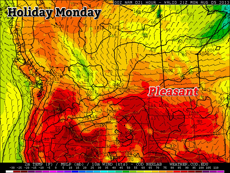
Nice Holiday Monday, but Then it Gets Ugly

The last day of the long weekend will be quite nice, but then conditions will turn ugly for Tuesday as a strong cold front pushes through.

Monday will be a Generally Pleasant Day in Southern Manitoba

Monday

Monday

Mix of Sun and Cloud. Chance of Showers.
25°C / 14°C

Today will be fairly nice in Southern Manitoba. Afternoon temperatures will be in the mid twenties under a mix of sun and cloud. The atmosphere will be a bit unstable later in the day, meaning that some isolated showers or thunderstorms may develop. These showers and storms are most likely to occur along and north of the Trans-Canada, though some areas south of the highway will still stand a slight chance of seeing an isolated cell move through. Wind speeds will be light, so overall it will be a quite a nice day in those areas that don’t see any showers or storms move through.

Tuesday

Tuesay

Rain early, then Decreasing Cloudiness
18°C / 5°C

The weather will be in transition on Tuesday as a strong cold front blows through early in the morning, setting up unseasonably cool weather for much of the week. There will likely be some showers, or perhaps even thundershowers, associated with this front as it passes through. However, amounts don’t look to be particularly high. In total, amounts will probably range from about 5 to 15mm, with locally higher amounts. Once the rain clears the region on Tuesday morning, temperatures won’t recover very much. Highs on Tuesday will only be in the mid to upper teens with a stiff northerly wind. Obviously Tuesday will be an unpleasant day, certainly not what we’d hope for in early August.

Wednesday

Wednesday

Increasing Cloudiness. Chance of Showers.
19°C / 9°C

Wednesday will be another cool day in Southern Manitoba from start to finish. Early morning temperatures will be in the mid single digits, with a recovery to the upper teens or perhaps twenty degrees by afternoon. Unfortunately, the atmosphere will quickly destabilize with daytime heating, prompting numerous showers to develop by afternoon. By this point you can probably recognize that this week isn’t going to be very nice.

Long Range

Medium range weather models suggest that the remainder of the work week will stay cool and showery. In the longer range models suggest we may begin to see temperatures trend back towards normal by next weekend, but that is still a bit far away to get overly excited about.