Showery Weather Ahead

A persistant Arctic vortex over the Eastern Arctic will continue reinforcing a westerly to northwesterly flow over the Prairies which has been bringing cooler summer weather to Southern Manitoba. Multiple disturbances are forecast to track down in the northwesterly flow which will produce a showery second half to the week.

Wednesday

22°C / 13°C
Increasing cloudiness then showers with a risk of a thunderstorm in the afternoon.
Thursday

21°C / 11°C
Cloudy with scattered showers. Windy.
Friday

22°C / 10°C
Mainly sunny.

We’ll see a fairly cloudy day today as temperatures climb to only around 22°C. A trough of low pressure will work it’s way into and through the Red River Valley bringing scattered showers with the risk of a thunderstorm through much of the day and the early evening. No severe weather is expected. Skies should clear overnight as we drop to a low of around 13°C.

On Thursday a second – more potent – system will begin working it’s way through the province. Clouds will roll in early on Thursday as an upper disturbance tracks an area of rain through the Interlake. Here in the Red River Valley we’ll likely see another round of scattered showers starting midday with the winds picking up out of the north to around 30km/h with gusts to 50 or 60km/h. Thunderstorms aren’t expected and we’ll see a high near 21°C. Things will clear out overnight as we head to a low of about 11°C.

Friday will bring more stable weather with mainly sunny skies and a high of 22°C. Winds will continue to be breezy through the morning but should begin to let up in the afternoon. Things look very pleasant through the weekend with mainly sunny skies and highs in the mid–20’s with overnight lows in the 12–13°C range.
A Cool But Dry Start to the Week

Below-seasonal temperatures will persist through the beginning of this week but that gloomy news will be offset by the fact that we should see plenty of sunshine over the next couple days. A disturbance tracking through the Dakotas will bring a chance of showers for the Red River Valley on Wednesday as it pushes the coldest air out of the Red River Valley and pushes us back towards seasonal temperatures.

Monday
image
19°C / 6°C
Sunny. Increasing cloud overnight.
Tuesday
image
18°C / 7°C
Mainly cloudy. Chance of showers near the U.S. border.
Wednesday
image
16°C / 7°C
Clearing in the afternoon. Channce of showers near U.S. border.

Monday

We’ll see nothing but sun today as a ridge of high pressure dominates the weather over the Red River Valley. Daytime highs will sit near 18 or 19°C. We’ll have another cool evening tonight with lows dipping to around 5°C.

Tuesday & Wednesday

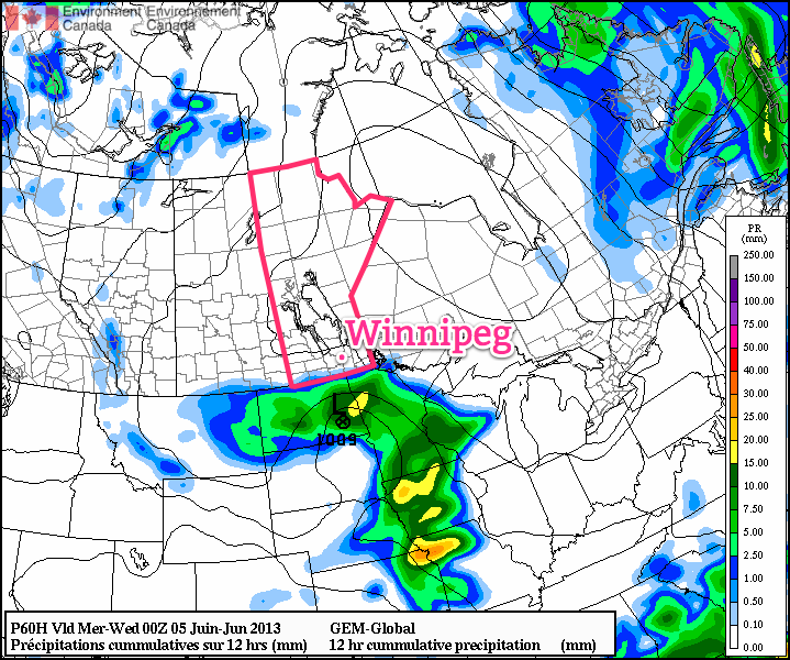
Cloud will begin to push in on Tuesday as a low pressure system begins to work it’s way into North Dakota. The chance for precipitation in Winnipeg is very minimal, but closer to the international border it’s more likely that a shower or two will be seen. A sharp cutoff is expected from accumulating rain to nothing, and while the models have been trending towards keeping all the rain on the US side of the border, it’s important to note that around 10mm of rain is forecast for areas only 75–100km south of the Canadian border.

GDPS Precipitation for Tuesday.

Rainfall expected through the day on Tuesday. A sharp cutoff is expected from the accumulating rainfalls in North Dakota and little-to-no rainfall in Southern Manitoba.

While just a few spits of rain is most likely for soaked communities in the southern Red River Valley, we’ll definitely be keeping our eyes on it. If the system ends up just a bit further north than forecast, areas such as Treherne, Morden, Gretna, Altona, Letellier & Emerson could see some light rain. For now, though, I’m expecting just a chance for a shower or two.

Rest of the Week

Heading through the rest of the week it looks like we’ll see couple of mainly sunny days on Thursday & Friday with temperatures climbing back to seasonal[1]. The weekend is worth keeping an eye on as another strong upper low is forecast to move into the region bringing showers and the potential for a few thunderstorms.


  1. The normal daytime high for Winnipeg at this time of year is around 22°C.  ↩

Return to Cooler Conditions

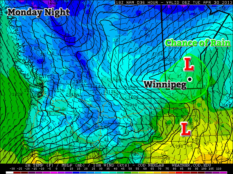
After a beautiful weekend we’ll unfortunately slip back into well below normal weather this week. This cooler weather will be triggered by the passage of a weather system on Monday.

image

A weather system will bring rain to Southern Manitoba on Monday

Today

image
Increasing clouds. Periods of rain in the afternoon-overnight.
12°C / 6°C

Today will be a fairly normal late April day. Temperatures will be in the low teens with a breezy south wind. Cloud cover will increase during the day, with there being a chance of rain beginning in the afternoon and lasting into the overnight period. This rain will be generated by a fairly strong, complex low pressure system moving through Southern Manitoba and North Dakota today. It is quite difficult to figure out what accumulations might be as the rain may end up quite showery & localized, but my guess would be around 10mm in general with locally higher amounts. The first shot of precipitation will push through in the afternoon as low-level jet over-running a weak warm front slides across the province. This precipitation will be convective in nature, meaning rainfall amounts could be fairly significant (10-20mm) in a short period of time and relatively localized. Those showers will clear out in the evening before a second batch of precipitation arrives with the main low center late overnight. Here in the Red River Valley, that means that we’ll likely see some more shower activity overnight.

Tuesday and Wednesday

Tuesday
image
Chance of Flurries.
6°C / -2°C
Wednesday
image
Mix of sun and cloud
3°C / -3°C

A cold front will swing through tonight, ushering in cooler temperatures for Tuesday. The showers tonight may transition into some flurries on Tuesday morning as this cooler air moves in. Fortunately, these flurries won’t amount to anything, but they will signal a shift back into unpleasant, below-normal conditions. On Tuesday we’ll only see high temperatures in the low single digits with similarly cool values on Wednesday.

Long Range

In the long range there is no sign of a shift towards a more consistently above normal pattern. It looks like we’ll see near normal conditions return around the weekend, with some days being a bit below normal, with others are slightly above normal. There is also no sign of significant precipitation in the long range, which is a good for the flood situation.

Another Shot of Snow on the Way

More snow is on the way for Southern Manitoba this weekend as a low pressure system moves across the Dakotas.

NAM Precipitation Accumulations for Saturday

NAM liquid-equivalent precipitation accumulations for Saturday afternoon/evening.

It will be a cool day across the Red River Valley today as any left over cloud moves out, allowing our temperatures to slowly drop to around -16°C by this afternoon. Temperatures will dip down to around -21°C tonight before some cloud associated with the approaching low pressure system moves in.

Snow will spread into southwest Manitoba tonight and reach the Red River Valley tomorrow morning. It will last through much of the day before tapering off in the evening. One of the main challenges with this system is it’s complex nature: the feature pushing across Southern Manitoba is known as an inverted trough. These complicated features are notorious for being difficult to forecast the snowfall intensities they’ll produce.

In general, it looks like the heaviest snowfalls will be along and south of the Trans-Canada Highway, including Winnipeg, with an average of 5-10cm. There are some hints within the model outputs that some areas may see as much as 10-15cm, however it’s a little hard to say that with confidence since there is absolutely no developed reflection of how this system is taking shape right now. The area that is most likely to potentially exceed 10cm of snowfall is in extreme SE Saskatchewan into SW Manitoba, west of the RRV and south of the TCH. At this point, it looks likely that Winnipeg will see 5-8cm of snow tomorrow.

Skies will clear across Southern Manitoba tomorrow night, bringing another cold night to the Red River Valley with overnight lows dipping to -20°C. Sunday will be mainly sunny with a high of about -15°C.