Gloomy Thanksgiving Monday

This Thanksgiving will be nothing like last year’s (which featured temperatures in the twenties), as rain and wet snow make for a rather miserable holiday Monday.
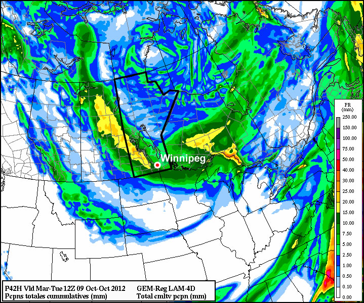
Total precipitation accumulation for Monday's system

The GEM model shows generally 10-20mm of precipitation over Southern Manitoba

A low pressure system sliding south-eastward through Manitoba on Monday will be responsible for the precipitation, with rain beginning to move into Southern Manitoba early Monday morning. Temperatures on Monday will be cool, but generally not cold enough for snow with values hovering in the mid single digits during the daytime. By evening there will be a changeover to snow in some areas, mainly portions of Western Manitoba, as colder air is pulled down from the north. Areas in the Red River Valley can expect a bit of wet snow late Monday evening into the overnight period, but with surface temperatures remaining above zero, no notable accumulation is expected. Total precipitation accumulations will generally range from 10 to 20mm across Southern Manitoba by early Tuesday.

Unfortunately, conditions will improve little for Tuesday. It will be a chilly start to the work-week as cold air pulled down by the previous day’s low pressure system will not allow temperatures to climb much higher than the mid single digits at best. Monday’s low pressure system will have departed by Tuesday morning, so no more significant precipitation is expected (save for perhaps a few scattered showers or flurries). At this point models keep us in the single digits for Wednesday as well, so even normal weather will continue to elude us.

The late week period looks to remain fairly miserable, with temperatures staying stuck in the single digits. No more significant precipitation is expected later this week.
Improving Weather, But Remaining Cool

The effects from the low pressure system responsible for yesterday’s dump of snow over southeastern Manitoba will linger for one more day before moving off and returning us to sunnier skies.

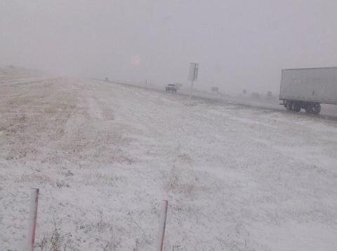
Snow piles up on the Trans-Canada Highway

Snow resulted in the Trans-Canada highway being reduced to one lane each direction as numerous cars hit the ditch due to icy road conditions.

We’ll see widespread flurries over the Red River Valley today, however the potential exists for significant accumulation in the lee of Lake Manitoba and Lake Winnipeg. Brisk northerly winds, combined with strong instability over the still-warm lakes, will advect fairly strong lake-effect snow bands southwards off the lakes. These will be long, narrow features that will depend significantly on the wind direction. Currently, it appears that the heaviest flurry activity will be along a N-S line near Portage la Prairie, and another N-S line just east of Winnipeg. Should the winds back to a little more NE than northerly, Winnipeg could certainly see some of the action. Most locations that see just general flurry activity will likely receive 2-4cm of snow; how much actually stays on the ground will be highly dependent on what the pre-existing ground cover is like. Areas that have mostly bare ground right now should have enough heat coming off it to melt most of the new snow that falls. Areas in the eastern half of the Red River Valley, which already have had 10-20cm of snow fall, will definitely see the snow slowly pile up on top of the existing stuff. For those that get caught for any significant period of time under the lake-effect bands of snow, 5-10cm is certainly possible, if not even a bit more than that.

Winds will remain fairly strong today out of the north at around 40km/h with gusts to about 60km/h. Temperatures will struggle through the day, with plenty of cloud and cold advection occurring; we’ll probably only see 2°C or so..perhaps up to 3°C.

Things begin to improve tonight; winds will die down this evening and the cloud cover will start to clear as a ridge pushes into southern Manitoba from the northwest. Temperatures will hover around 0°C until the clouds break up, then temperatures will drop to about -5°C for the remainder of the night.

For Saturday, we’ll see sunny skies over southern Manitoba as we sit under the influence of an arctic ridge. Temperatures will only climb to about 7°C, so it will remain fairly chilly despite the sunshine.

On Sunday we’ll see increasing cloud throughout the day and a high of about 8°C. The cloud is coming ahead of a low pressure system dropping southwards from the Arctic along a reinforcing blast of cooler air. Showers will push into portions of the northern Red River Valley overnight, with the more organized precipitation looking to fall over the northern and eastern Red River Valley into the Whiteshell on Monday. Currently, it looks as though this precipitation will fall as rain.

Strong Winds Blast Southern Manitoba

Strong winds will blast across Southern Manitoba today as a very powerful low pressure system crosses Northern Manitoba. The winds will also usher in an unseasonably cool air mass that will give us a very chilly night before the upper ridge begins to rebound into our region.

850mb Temperatures for Thursday morning from the GEM-REG

850mb temperatures for Thursday morning from the GEM-REG. A cold trough of 850mb temperatures between 0-1°C will rest over the Red River Valley and Whiteshell, contributing to unseasonably cold overnight lows.

A powerful low pressure system with a central pressure of approximately 984mb is pushing across Northern Manitoba and will bring a very strong pressure gradient across the Red River Valley today that will usher in 50-60km/h winds with gusts as high as 80km/h. This system has a history of producing very strong winds; on Monday it brought widespread winds in excess of 100km/h to Southern Alberta and yesterday it brought winds between 80-110km/h through Saskatchewan and Northern Manitoba.

The winds will pick up in the Red River Valley this morning and we’ll see several hours of fairly strong westerly winds. Unlike regions to our west that had to deal with the winds for a fairly prolonged period of time, the winds will move through the region fairly quickly as the low accelerates out of Northern Manitoba into Hudson Bay. As a result, winds should let up noticeably by the evening.

In behind this system, fairly cold air will sweep across the province. Across the Red River Valley, overnight lows will be kept a little warmer by some light winds expected to continue through the night. Through the Red River Valley, overnight lows will generally drop to 3-5°C tonight, however if any areas see the wind let up, it would certainly be possible to see overnight lows dip to 1-2°C under clear skies and calm winds. The most likely area for this to happen, though, is a little further east in the Whiteshell where the trees will help protect the surface from light synoptic winds.

Temperatures will return to seasonal on Thursday as an upper ridge begins to build eastwards across the Prairies. We’ll see a mix of sun and cloud across the Red River Valley with a very slight chance of a shower as warmer air begins to push into the region. Daytime highs should be near 19-20°C on Thursday with overnight lows on Thursday night once again rather chilly in the 4-6°C.

Warm air moves back in for the weekend, with plenty of sunshine and highs near 25°C on Friday and Saturday. Things look to cool off a bit on Sunday as another cold front passes through.

A Cooler Weather Regime

Cooler, more seasonable, weather is going to move into Southern Manitoba for the week ahead as a large upper trough swings into the region.

GEM-REG 500mb Winds valid Tuesday Morning

GEM-REG 500mb wind field valid Tuesday morning. A deep upper low is straddling the SK MB border with a trough extending to the SW denoted by the dashed black line.

A strong upper low sitting over the northern Prairies is in the process of stalling out over Northern Manitoba as it’s been captured by a significant long-wave trough. While today will be quite pleasant with sunshine and daytime highs across the Red River Valley near 28°C, the aforementioned trough will be moving into our region tomorrow.

With this system stalled out over the province, we’ll be stuck under cooler air for the rest of the week; daytime highs will sit around the low-20’s under a mix of sun and clouds or cloudy skies. Winds are expected to be fairly light through the week and overnight lows will sit around 10-13°C.

While Northern Manitoba will be fairly wet this week, it looks like we’ll be relatively dry in Southern Manitoba. The best chance for rain looks to be on Wednesday night into Thursday as a small reinforcing trough swings through the Red River Valley. Things then look to improve slightly over the weekend as an upper ridge starts to push across the Prairies, however another powerful low pressure system is forecast to move through Southern Manitoba and bring another batch of cooler air across the Prairies next week as it ushers in another cold trough.