Major Warm-Up To Start April

It look like a major warm-up will usher in the month of April. These warmer conditions come after an abnormally cold March.

image

High pressure will dominate at the surface on Monday (College of Dupage image)

…April fools! No major warm-up is in the cards this week, so read on to see what you can actually expect.
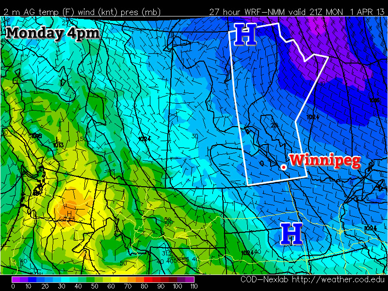
Monday

Monday
image
Mix of sun and cloud. Chance of flurries.
-6°C / -12°C

Monday will be a very similar day to Sunday. The lower atmosphere will once again be quite unstable, so flurries will be possible throughout Southern Manitoba. These flurries will be fairly localized in nature and will not affect everyone. Those areas not under the influence of these flurries will see a mainly sunny day, while other areas will see a combination of clouds and flurries as well as periods of sunnier skies. Generally speaking, high temperatures will be in the mid to upper minus single digits, making it a seasonably cold start to April.

Tuesday and Wednesday

Tuesday
image
Mainly Sunny
-4°C / -8°C
Wednesday
image
Mix of sun and cloud. Chance of flurries.
2°C / -10°C

Tuesday will be slightly warmer than Monday, but not by much. Highs will be in the mid single digits in most areas. The wind will be calm and the sky sunny, so the cities and forested areas will once again be slightly warmer than everyone else.

We will finally warm up to the melting point again on Wednesday, but it won’t be a major warm-up. All of Southern Manitoba should see high temperatures in the low to mid positive single digits.

Long Range

In the longer range models are struggling to resolve the pattern. It appears fairly certain that a cold front will come through on Wednesday night, making Thursday a cooler day once again. However, beyond that things are quite unclear. Some model runs have been showing consistently warmer weather into next weekend, while others have shown cold weather persisting. We’ll just have to wait and see what happens…

Clouds To Start Breaking Up

The overcast weather will begin to break this weekend as a system tracking through the central Prairies brings drier air eastwards across the Prairies. Temperatures will cool off with the clearing skies, but the sun will be a welcome sight that may make many not care.

Snow in Assiniboine Park

A snowy, overcast scene at Assiniboine Park, courtesy “Mentally Guitarded.”

Clouds will stick around for today with continued periods of light snow as temperatures continue to remain in the optimal snow-generating range. Winds will be light out of the south as we reside on the back-side of a ridge which passed through overnight and temperatures will climb to around -11°C. As a low pressure system tracks across the Prairies tomorrow, higher-level cloud will begin to stream over Southern Manitoba. This mid-cloud will help produce scattered snow showers in areas that have been socked in with low cloud for a while, but also begin to dissipate that persistent low cloud as well.

On Saturday we’ll likely see a mix of sun and cloud as more mid-level cloud streams over the southern portion of the province. There should be some sunny breaks as well and temperatures will climb once again to around -12°C. Clouds will break up a little overnight as cooler air pushes in from the northwest behind this system and we’ll head to an overnight low closer to -20°C. By Sunday, we should see a little more sun than on Saturday with temperatures climbing only to around -16 or -15°C. No significant snow accumulations are expected through the weekend.

Next week, including Christmas, is looking fairly sunny and cool, with overnight lows near -25°C and daytime highs near -18°C. We’ll be taking a slight vacation over Christmas here at AWM, so have a great holiday and a happy new year!

Snow Today, Cooler For Week’s End

Light snow will very slowly taper off through the day today, leaving us with slowly clearing skies and cooler weather.

NAM Sounding valid 4PM Wed Dec 19

A sounding from the NAM for Winnipeg valid at 4PM today. The areas of the line that are coloured yellow denote effective snow making regions in the atmosphere (a combination of temperature & humidity).

Light snow that pushed into the Red River Valley overnight will taper off this evening; despite the fact that the system will be pushing out of the province mid-day, the temperature structure of the lowest 2-3km of the atmosphere will remain highly favourable for the generation of snow, so we’ll likely see additional snowfall through the day today similar to Monday. In total we’ll likely see 4-8cm of new snow through the Red River Valley. Clouds look to begin to break up overnight leading to a cooler night than we’ve had lately with temperatures dropping to around -15°C.

Thursday will bring mainly sunny skies with very little temperature recovery; daytime highs through the RRV will be only -14 or -13°C. The clear skies look to persist through week’s end as cooler air continues to push into the region: overnight lows on Thursday night will drop another couple degrees to about -18°C while temperatures look to climb to only around -15°C again on Friday.

The weekend looks clear but cool, with overnight lows near -25°C and daytime highs near -20°C.

Cool Weekend Ahead

Arctic air will keep temperatures cool through the weekend with daytime highs some 5-7°C below normal. Scattered flurries will be common through the weekend, while a significant lake-effect snowfall event will impact portions of the Whiteshell and Eastern Manitoba.

850mb Temperatures Valid Saturday Morning

850mb temperatures valid Saturday morning. A deep pool of Arctic air will flood across the Prairies this weekend.

As the low that brought rain to Southern Manitoba the past few days pushes northwards into Hudson Bay, it will intensify quite considerably1 and induce a strong northwesterly flow over the Canadian Prairies. This cold air will likely produce isolated scattered flurries, however the largest effect will be strong lake-effect snow bands, primarily from the basins of Lake Winnipeg. These lake-effect bands will mainly effect the Bisset region and slowly push northwards towards Berens River as the winds back slightly to westerly through the weekend. Substantial amounts of snow are possible with these bands, with the potential for anywhere from 15-30cm of snow possible in areas that see a band have a particularly long residence time over them.

Daytime highs over the next few days will sit within a degree or two of 0°C, with overnight lows near -6 or -7°C. No significant improvement in temperatures is expected until potentially early next week as a low pressure system moves through the Central Prairies and brings ever so slightly warmer air back to the region.


  1. It’s currently forecast to deepen from a 982mb low this morning to a 967mb low tomorrow morning.