Cooler Air Pushing Southeast Across Southern Manitoba

The powerful low pressure system that has brought rain to Winnipeg over the past couple days and is bringing 10-20cm of snow to portions of Northern Manitoba has pushed north and east of the Red River Valley, setting the stage for cooler air to filter into the region.

700mb Temperatures for Thursday Morning

NAM forecast of 700mb heights & temperatures valid Thursday morning.

The Red River Valley will be moving into a strong northwesterly flow aloft that will advect cooler air into the region. While earlier in the week, models were projecting a very potent arctic blast, things have become a little more pleasant due to a more significant amplification of the upper-level pattern. The net result of this is a cut-off upper low over the central Prairies that will, in effect, block the coldest air from being able to push southwards. This will give us more cloud than sun with daytime highs near 5 or 6°C through the rest of the work week.

The upper low begins to push eastwards for the weekend, allowing slightly cooler temperatures to the area for the weekend, with highs near 0°C, and a chance of some light snow. Accumulations will be light-to-none throughout the RRV, however a few cm may pile up in the Interlake region.

Improving Weather, But Remaining Cool

The effects from the low pressure system responsible for yesterday’s dump of snow over southeastern Manitoba will linger for one more day before moving off and returning us to sunnier skies.

Snow piles up on the Trans-Canada Highway

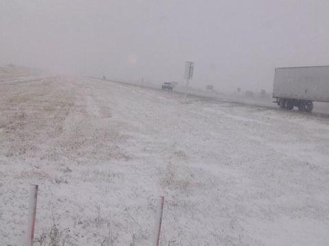
Snow resulted in the Trans-Canada highway being reduced to one lane each direction as numerous cars hit the ditch due to icy road conditions.

We’ll see widespread flurries over the Red River Valley today, however the potential exists for significant accumulation in the lee of Lake Manitoba and Lake Winnipeg. Brisk northerly winds, combined with strong instability over the still-warm lakes, will advect fairly strong lake-effect snow bands southwards off the lakes. These will be long, narrow features that will depend significantly on the wind direction. Currently, it appears that the heaviest flurry activity will be along a N-S line near Portage la Prairie, and another N-S line just east of Winnipeg. Should the winds back to a little more NE than northerly, Winnipeg could certainly see some of the action. Most locations that see just general flurry activity will likely receive 2-4cm of snow; how much actually stays on the ground will be highly dependent on what the pre-existing ground cover is like. Areas that have mostly bare ground right now should have enough heat coming off it to melt most of the new snow that falls. Areas in the eastern half of the Red River Valley, which already have had 10-20cm of snow fall, will definitely see the snow slowly pile up on top of the existing stuff. For those that get caught for any significant period of time under the lake-effect bands of snow, 5-10cm is certainly possible, if not even a bit more than that.

Winds will remain fairly strong today out of the north at around 40km/h with gusts to about 60km/h. Temperatures will struggle through the day, with plenty of cloud and cold advection occurring; we’ll probably only see 2°C or so..perhaps up to 3°C.

Things begin to improve tonight; winds will die down this evening and the cloud cover will start to clear as a ridge pushes into southern Manitoba from the northwest. Temperatures will hover around 0°C until the clouds break up, then temperatures will drop to about -5°C for the remainder of the night.

For Saturday, we’ll see sunny skies over southern Manitoba as we sit under the influence of an arctic ridge. Temperatures will only climb to about 7°C, so it will remain fairly chilly despite the sunshine.

On Sunday we’ll see increasing cloud throughout the day and a high of about 8°C. The cloud is coming ahead of a low pressure system dropping southwards from the Arctic along a reinforcing blast of cooler air. Showers will push into portions of the northern Red River Valley overnight, with the more organized precipitation looking to fall over the northern and eastern Red River Valley into the Whiteshell on Monday. Currently, it looks as though this precipitation will fall as rain.

Unsettled, Cool Weather

We’ll see showers in the Red River Valley this morning as a low pressure system slides through the Interlake and Whiteshell regions but, unfortunately, little accumulations are expected as the more significant rain will stay north and east of the Valley. More cool days are ahead as this system reinforces the colder air over the province.

Rainfall Map

A low pressure system will track SE into Ontario today, bringing with it a large area of rain, represented in blue, and showers, represented in green, to Southern Manitoba.

A low pressure system dropping southwards from Northern Manitoba has pushed an area of showers through the Interlake overnight and will bring that rain through the Whiteshell and Sprague regions today. As pictured above, the low will track far to our NE into Ontario, leaving the Red River Valley with only disorganized instability in a strong NW flow pumping cooler air southwards on the backside of this system.

Temperatures through the RRV will stay steady today at 12-13°C as strong northwesterly winds pick up as the day progresses. Winds across the valley will pick up to 50km/h with gusts as high as 70-80km/h by late this morning and remain that way through most of the afternoon before beginning to ease this evening. A chance for showers exists through the whole RRV, and models are hinting that there may be some narrow, banded areas of precipitation that develop that could result in localized amounts of 2-4mm. Areas in the southwest RRV, such as Morden, will likely see nothing more than a passing sprinkle or two today while areas closer to the South Basin will likely see showers this morning.

We’ll see cool nights ahead, with lows near 3 or 4°C for the rest of the week. Thursday and Friday will bring us a mixed sky and highs only around 14°C.

Another system will push it’s way through the area on Friday, bringing another batch of scattered showers to the RRV. No significant amounts are expected across the Red River Valley.

Stormy Night Ahead; Cooler Weekend

Another 30°C+ day will give way to stormier weather tonight as a cold front pushes across Southern Manitoba. We’ll see a slightly cooler weekend than the weather of late as we remain in the cooler air behind this system.

Precipitable Water for Friday Night

Precipitable water from the GEM-REG as the cold front pushes into the RRV tonight. Elevated values of 40-50mm through the RRV indicate the potential for stronger storms with locally heavy rainfall.

We’ll see temperatures climb into the low 30’s across Southern Manitoba again today as we remain under the influence of a pool of warm air entrenched over the Eastern Prairies. After some of this morning’s debris cloud from last night’s nocturnal convection clears out, here in Winnipeg we’ll climb to a high near 31 or 32°C, while areas to our south could reach as high as 33°C today.

Things will change promptly this evening as a cold front pushes across the province. Showers and thunderstorms will develop along the front in the early to mid-evening and continue to grow in coverage as the night progresses. This line of showers and thunderstorms will move through the Red River Valley overnight, bringing 5-15mm of rain to the region, the potential for some areas to see a bit over 1” total accumulation, and hopefully a good light show. These storms are not expected to be severe, and could potentially be one of the last night-time light shows we’ll get in 2012.

Tomorrow we’ll see a daytime high only around 24°C with a southwesterly wind at 20-30km/h. Sunday will reach about 25°C with lighter winds. Skies should be mostly sunny both days, with just an occasional cloudy patch here and there.

Temperatures are expected to climb back towards the 30°C mark through the first half of next week.