Elsewhere in Weather News: April 5th, 2014

Madagascar Hit by Strong Cyclone

Madagascar’s week did not start off on a high note, as a strong cyclone dubbed “Cyclone Hellen” took aim at the country. Hellen took a turn towards Madagascar on Sunday and quickly deepened due to ideal cyclone conditions – as much as 60mb drop in 24 hours – over the warm waters surrounding Madagascar. Considered a very powerful storm for the country, this category four cyclone brought winds of 230km/h, while located in the northern part of the Mozambique Channel to the northwest of Madagascar.

Image of Hellen on Sunday, after it underwent rapid intensification, still over the northern Mozambique Channel. A well-defined eye can be seen. (Source: NASA: MODIS/LANCE)

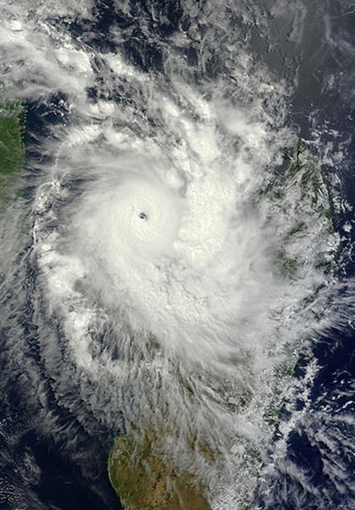
Fortunately, the saving grace that helped avoid widespread damage to the country was that the eye of the storm was very compact and it collapsed easily after moving off of the warm ocean waters. The surface pressure of the cyclone went back up 65mb in the following 24 hours. Because of this, sustained winds significantly weakened to around 80km/h after making landfall therefore only a few coastal areas received damage to structures. Mahajanga, a large city with a population of over 100,000 and located close to where the cyclone made landfall, received just over 150mm from the storm. Although landslides were of concern over Madagascar’s rugged inland terrain, residents took necessary precautions and no injuries were reported. Hellen’s remnants lingered over Madagascar before getting pushed over to the neighbouring country, Mozambique, then dying off.

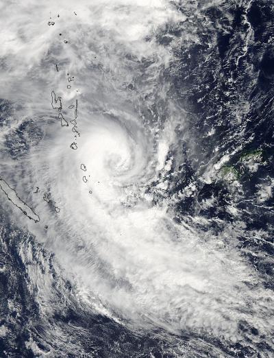
Another unrelated tropical storm is currently spinning up in the western Pacific Ocean and is headed toward the Philippines. This storm however, is not benefiting from ideal conditions for typhoon intensification. It is not expected to strengthen to more than a category one and will likely be more of a rain-maker than a powerful storm. The small Pacific island of Palau should still be on the lookout though, as the storm is on track to pass directly over the island. Regardless, an eye (no pun intended) will need to be kept on this storm.

Elsewhere in Weather News: March 15th, 2014

Cyclone Lusi Heads towards New Zealand; Otherwise a Calm Week

The weather this week has been fairly uneventful but the most significant event has been the three tropical storms that churned simultaneously off Australia’s north and east coast earlier this week. The strongest of the three storms, Cyclone Lusi, was of category three at its strongest point when it moved over the Island of Vanuatu. Vanuatu is an Island on the eastern side of the Coral Sea, near New Caledonia. Flooding was the biggest of the resident’s worries as the cyclone was fairly slow moving; affecting the island from Monday through Wednesday. Of course, strong winds were also problematic as many houses on the island are not built to withstand category three cyclone winds (120km/h). Long-term damage could also be concerning – crops destroyed and freshwater contaminated by flooding waters. Nearly 40,000 people living on the island were affected and about 100 people were evacuated from low-lying areas. Unfortunately, six people perished from trees falling on houses and fast currents associated with the floodwaters.

Cyclone Lusi as seen by NASA's Aqua satellite on March 12th, after the cyclone had passed over the northern islands of Vanuatu. (Source: NASA)
Cyclone Lusi as seen by NASA’s Aqua satellite on March 12th, after the cyclone had passed over the northern islands of Vanuatu. (Source: NASA)

The cyclone continued its trek southwards towards New Zealand where it is expected to make landfall this morning. As it moved south the cyclone encountered colder waters causing it to weaken significantly and start its transition to an extra-tropical storm. On Friday evening the cyclone still packed somewhat of a punch as it affected the northern island of New Zealand; about 7,200 people were reported to not have power and residents were urged to stay inside. New Zealand averages about one tropical storm per year.

Elsewhere in weather news, weather has remained relatively quiet across the globe, apart for severe thunderstorms affecting Argentina and Australia.

Elsewhere in Weather News: March 8th, 2014

Cyclone Takes Aim at Northern Queensland

On Thursday, March 7th an area of convection appeared off the northern coast of Australia in the Arafura Sea, associated with a weak tropical disturbance. Since then the convection has remained nearly stationary due to steering winds being fairly weak but not much organization has occurred. However, the disturbed area is expected to organize quickly today into tomorrow as it drifts slightly to the southeast where shear values are low and sea surface temperatures are very warm; 30-31°C. By Sunday evening it is expected that Gillian become a category two cyclone, just off the northern coast of Queensland.

Infrared satellite image of Gillian looking rather disorganized, but with some deep convection on Friday evening. (Source: CIMSS)

The Australian Bureau of Meteorology (BoM) warns that winds could approach 150km/h in areas closest to where it makes landfall. Shoreline areas are most at risk along the peninsula due to the storm surge and large waves. Flooding/flash flooding is also expected as areas along the coast have received around 850mm in February; over double their average rainfall for that month. Another 250-400mm could fall in the region due to Gillian. It is expected that Gillian linger through the beginning of next week and die out as it continues south over land.

Queensland's rainfall for the past 30 days, note the area of 800+mm, this is where Gillian is headed. (Source:BoM)
Queensland’s rainfall for the past 30 days, note the area of 800+mm, this is where Gillian is headed. (Source:BoM)

Interestingly enough a second, weaker, cyclone is spinning off the east coast of Queensland and is expected to make landfall at about the same time that Gillian does as a strong category one. Both cyclones are to watch Sunday into the beginning of next week as they pose a threat to the northern and eastern areas of Queensland. The Australian cyclone season begins November 1st and ends April 30th and on average they see about ten cyclones per year.

Elsewhere in Weather News: January 11th, 2014

Cyclone Ian Hits Tonga

This year’s first strong cyclone has spun up in the Southwest Pacific of the Southern Hemisphere. The cyclone – cyclone Ian, formed to the southwest of the Samoan islands and quickly strengthened under prime conditions for intensification. Yesterday the strongest part of Ian clipped the islands of Tonga, as a category four bearing winds around 225km/h and an estimated central pressure near 950mb. All kinds of hazards are associated with a cyclone of this strength: landslides, storm surges and flooding. These risks are enhanced because this cyclone is slow moving. Communications had been cut off from the northern islands on Friday night, where a state of emergency had been issued, therefore the scale of damage to the island remains unknown there. The island of Hunga had reported damage to homes that had their roofs blown off. Tonga’s capital, which is about 100km further south than the northern islands, did not take a direct hit and only minor damage/flooding has been reported there.


A small, but compact cyclone Ian can be seen on IR satellite passing over Tonga on Friday evening. (Source: CIMSS)

The cyclone is expected to continue moving southeast into the south Pacific where it will die off due to cold sea surface temperatures; unfavorable for development.

Australia Baking Under Intense Heat

In other news, Australia is experiencing an intense heat wave which broke numerous daily records as well as a few all-time records such as the new all-time high of 48°C reached at Narrabri on January 3rd. The country has been plagued with heat waves the past few years, including last year which was Australia’s warmest year on record since records started.