Elsewhere in Weather News: September 14th, 2013

Historical Flooding in Colorado

This past week Colorado has been absolutely swamped thanks to moisture streaming up from the Gulf of Mexico, riding up the Rocky Mountains (upslope flow) and then falling as rain. High pressure sliding down from the north in the US Plains as well as an upper-level low to the west drew in the moist air from the southeast. Generally, 850mb dewpoints could be found in the 15°C range and PWAT values around 40mm in Eastern Colorado. Plentiful moisture was in place – a recipe for heavy rains that had the possibility to fall for a long period of time. This became the case for Wednesday evening through Friday morning for Boulder, Colorado and surrounding communities.
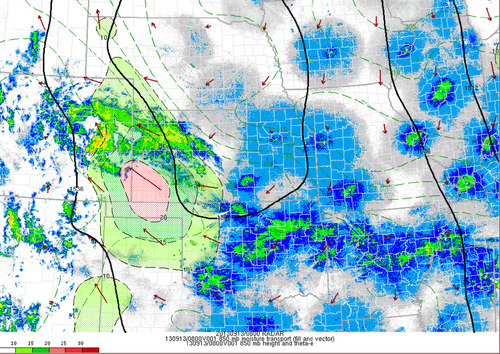
850mb moisture transport

Radar with overlay of the 850 moisture transport, notice the vectors all pointing towards the Rockies. Taken Friday 3am. (Source: SPC Mesoanalysis image archive)

As best described by NWS Boulder, flooding of “biblical” proportions took place is continues as of Friday night. Small creeks easily turned into raging rivers that inundated whole towns and mudslides blocked highways, took out buildings. The death toll is already at four but concerns of more as 172 people are still missing and some communities are literally cut off, with no roads leading in or out of town. Interstate 25 had been closed due to water running over it as well as numerous other highways that had simply been washed away.

The average rainfall per year for Boulder, CO is around 525mm, this means that in a few days Boulder got over half its annual rainfall at 310mm. This easily beats out the old record for rainfall in September (243mm), and average of 43mm (this month; 721% above average September rainfall). Interestingly enough, the area which received all this rainfall was under a moderate to extreme drought as per the Drought Index.
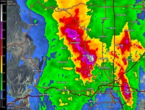
Rainfall estimates

Estimated rainfall from KFTG as of Friday 3am. Notice the dark purples/white; areas above 200mm estimates. Map storm total accumulation. (Source: GRLevel3)

It appears as though Boulder might get a break from the rain today as the upper-level low weakens and moves further east though there is still a slight chance for pop-up (non-severe) storms. Tomorrow will likely bring with it more rain for the region, unfortunately.
Elsewhere in Weather News: August 31st, 2013

Flooding Problems for Taiwan

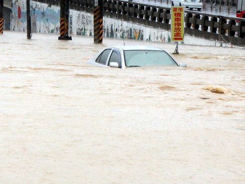
This past week the southern half of Taiwan has been experiencing significant flooding following a tropical storm that made landfall. Tropical storm Kong-Rey made landfall on the 29th bringing with it drenching rains. Very high rainfall accumulations along the west coast of Taiwan were reported, 500 millimeters in some areas within a span of 48 hours. That’s about as much rainfall as Winnipeg gets in a year! The flooding rains made so that second-story levels of building were underwater in some areas. Around 3,600 people had to be evacuated of the low lying areas while three perished in the floods.

Kong-Rey flooding

Flooding in Minsyong, Taiwan. (Source: Focus Taiwan News)

Kong-Rey has since moved off to the north-east and skirted around Japan’s west coast. No severe weather was experienced in Japan since it has been downgraded to a tropical depression and had significantly weakened. As of Saturday morning not much was left of the tropical depression as it has continued drifting into the Pacific and will die off there.

Elsewhere throughout the globe not much significant weather has been occurring this week. The Atlantic hurricane season has been remarkably slow this year with no hurricanes and only six tropical storms. No hurricane development is expected in the next few days, though September is on average the most active month of the year in the Atlantic.

Also, a quick update on the large California wildfire burning near Yosemite; the fire is now about a third contained as the crews continue to battle the fire. The weather pattern is expected to remain relatively the same as last week over the area – warm and dry for the coming week.

Elsewhere in Weather News: July 6th, 2013

Tropical Storm Erick

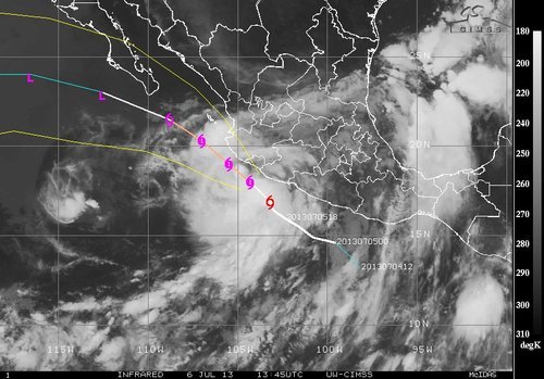
On Friday a tropical storm – tropical storm Erick, formed off Mexico’s coast, over the Pacific Ocean. Erick has been hugging Mexico’s west but staying over the Pacific. Since it has been staying over warm sea surface temperatures (SST) of about 28-29°C, Erick has had the chance to strengthen and is expected to become a hurricane. It currently has sustained winds around the 80km/h mark. But because of its proximity to land, SSTs gradually decreasing as you head north and a bit shear present, Erick is only expected to intensify into a category one hurricane this weekend. Mexico’s west coast is not in the clear though, cities and resorts such as Manzanillo, Tecomán and Puerto Vallarta are expected to receive heavy, possibly flooding rains from Erick’s outer bands. A hurricane watch has been issued for the region because of Erick.

Erick

IR picture of tropical storm Erick on Saturday morning. (Source: CIMSS)

After a few days of being close to the coast Erick is expected to take a left turn into the wide open Pacific Ocean and will succumb to its death as SSTs are much cooler and shear will tear the storm apart.

More Flooding in China

In other weather news, China has yet again faced severe flooding because of torrential rains that inundated eastern China and southwestern China. In the southwest it was not uncommon to see 24 hour rainfall accumulations of 200mm from the monsoonal rains. In the east, Shenyang was the hardest hit city where streets were flooded out and houses inundated. The flooding is blamed for 39 deaths this past week in China.

A few sunny days this weekend should let things dry out before the chance of rain will increase again early next week in Shenyang.

Elsewhere in Weather News: June 29th, 2013

Australia Faces Flooding Problems

This spring has been disastrous flood-wise across the globe; hundreds of billions of dollars of damage to crops and infrastructure from a few significant floods such as the Chinese floods, European floods and closer to home; Albertan floods as talked about in last week’s EIWN. Extreme flooding continues this week, most notably in Australia’s New South Wales state.

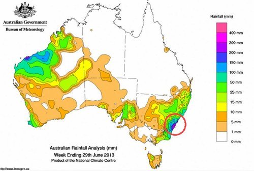
In the past few days coastal areas of New South Wales have received copious amounts of rain. Consequently, flood evacuations have had to be issued for a few towns just outside of Sydney (Richmond Lowlands, Pitt Town, Gronos Point). The Warragamba Dam, located to the west of Sydney, was overwhelmed by the 150mm of rain that fell in a 24 hour period starting Wednesday, prompting for the flood evacuations. Many roads and a few key bridges in the area had to be shut down because of the overland flooding. In addition, a few search and rescue missions have had to be executed because of people trapped in floodwaters. Thankfully no casualties have been reported as of yet related to this flooding.

Rainfall June 29

Rainfall map for the past 7 days as of Friday. Circled in red the area experiencing flooding, localized areas of 200mm+. (Source: Australia’s BoM)

It appears as though a lingering trough of low pressure is to blame for all the rain on the eastern coast of Australia on Wednesday. Sydney and surrounding areas get on average about 130mm of rain for the whole month of June. Compared to this past week where in some areas 200mm (or more) have already fallen, these areas have already doubled their average rainfall for June, significant flooding is not surprising. This weekend appears to bring more rain to the coast of New South Wales, though not another significant rainfall event.