Bitter Cold Seizes Winnipeg

Some of the coldest temperatures of the year are on tap for Winnipeg as a final blast of Arctic air spills across Southern Manitoba. The bitter cold will be short-lived, however, as a major pattern change this weekend will begin spreading significantly milder air across the Prairies.

Today will be a cold one with a ridge of high pressure clearing skies out early this morning and temperatures reaching a high temperature of just -22°C. Winds will start the day off out of the west at around 20 km/h and shift to the south in the afternoon.

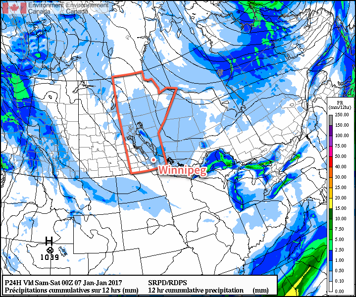
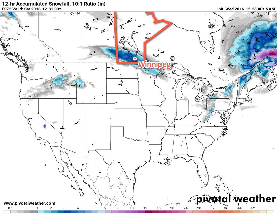
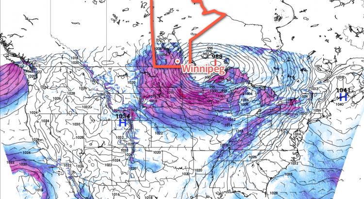
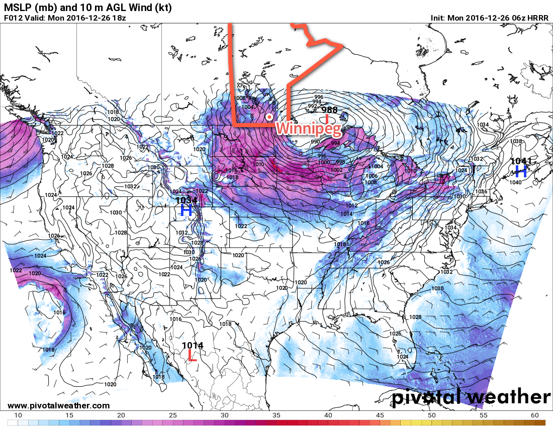
A weak low pressure system will round the base of the Polar Vortex tonight, swinging across southern Manitoba and bringing cloudy skies and some light flurry activity. The cloud cover will help prevent temperatures from dropping too low; early tonight temperatures will drop to around -26 or -27°C, but then begin to warm as the cloud moves in. By Thursday morning, the temperature will have climbed back to around the -20°C mark. No significant snow accumulations are expected.

A wide area of flurries are expected on Wednesday night with the passage of a weak low pressure system.

The overnight warming trend is all a cruel ruse, however, as winds shift northwesterly early Thursday and start ushering in the really cold air. Winds will strengthen to 30-40 km/h with gusts up to 50 km/h or so while temperatures drop to around -23°C. They’ll remain steady there as skies clear and winds gradually diminish through the afternoon.

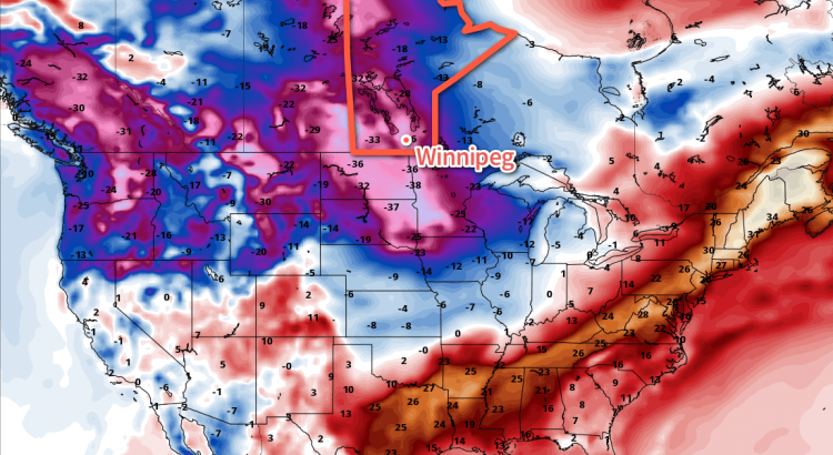
A potent Arctic high pressure system will move in on Thursday night, bringing light winds and extremely cold temperatures. Extreme cold warnings are highly likely across all of Southern Manitoba on Thursday night as temperatures plummet to overnight lows in the -30 to -34°C range. At these temperatures, winds of just 5-12 km/h will produce wind chill values of -401 and winds of that speed are produced simply by the movement of the air as it cools. By late overnight into Friday morning wind chill values will be in the -40 to -45 range.

Friday will be a very tricky day with respect to temperatures. Warmer air will begin working into the region from the west as a low pressure system building into the northern Prairies begins shunting the cold air to the southeast. However, winds will increase out of the south to southeast, feeding cold air out of the Arctic ridge back up the Red River Valley. In a best-case scenario, temperatures would likely climb to a high near -17°C, but if the cold air clings on, temperatures will languish with highs near -21°C.

That said, it won’t feel great outside as winds out of the south strengthen to 30-40 km/h. Skies will be mainly clear through the day. Winds will taper off in the evening and temperatures will remain steady through the night with just a few clouds.

Long Range

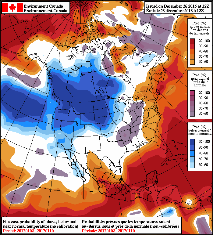
The story changes next week: nothing but above-normal temperatures flooding the Prairies.

Above-normal temperatures (red) will spread eastwards across the Prairies by Monday.

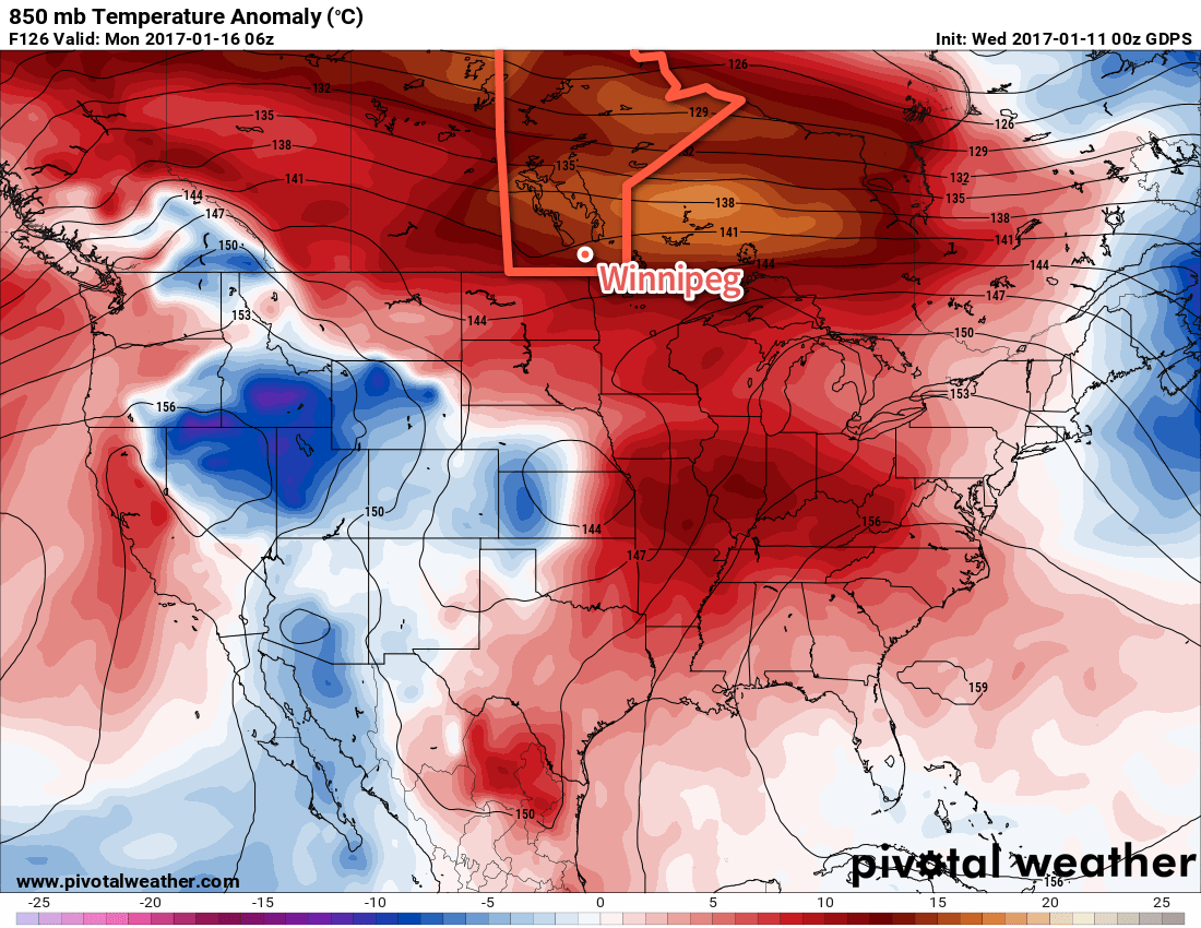
The jet stream will shift northwards for next week, drawing mild Pacific air across the Rockies and the Prairies. An extended period of mild temperatures are expected with daytime highs climbing from around -6°C on Sunday to the 0°C mark by mid-week. The mild weather will likely continue through next weekend. Hooray!

Winnipeg’s seasonal daytime high is currently -13°C while the seasonal overnight low is -24°C.


  1. This wind chill value is Environment Canada’s criteria for issuing an extreme cold warning. 

Light Snow Starts Off A Cool Weekend

Below-normal temperatures will remain entrenched across Winnipeg & the Red River Valley as another weak disturbance brings some light snow and a reinforcing shot of Arctic air.

A weak disturbance moving across Southern Manitoba today will bring plenty of cloud and another batch of light snow to the region. While there will be a chance for some light snow throughout the day, it’s most likely to be seen through the afternoon and early evening. Fortunately it won’t amount to much with nothing more than a skiff expected. Temperatures will climb to a high near -19°C today, and then drop to a low near -27°C tonight as skies clear behind this system.

Much of central and southern Manitoba will see some light snow today.

Saturday will bring fairly sunny skies and a high near -18°C. Winds will be relatively light, so it may actually be a nice day to be outside, despite the cool temperatures. Milder air will begin moving on on Saturday night ahead of a system that will impact the region on Sunday, so overnight lows won’t be quite as chilly as the past several. For Winnipeg, we’re expecting the temperature to drop to around -25°C.

Sunday brings more cloud and some light snow to the region once again as a weak disturbance rolls through. Temperatures will be milder with a high near -16°C and fairly light winds. Skies will clear on Sunday evening followed by plummeting temperatures with overnight lows likely falling into the -27 to -30°C range.

Long Range

Next week continues cold with temperatures mostly below the -20°C mark. Tuesday and Wednesday may be slightly warmer with highs in the mid-minus teens, but those warmer temperatures have the potential to bring some more now and the wind will be a bit more prominent, which may make it feel cooler than it does this weekend.

Winnipeg’s seasonal daytime high is currently -13°C while the seasonal overnight low is -24°C.

A Mixed Bag Heading Towards the New Year

Winnipeg will see a bit of a mixed bag over the next few days with some light flurries, some sun, and more accumulating snow on the way.

Today will bring some light flurries to the region as a weak disturbance moves out of the Red River Valley. Accumulations are expected to be minimal, and the light snow will taper off towards the afternoon as the clouds begin pushing off to the east, allowing a bit of sunshine through the afternoon in Winnipeg. Temperatures will be much milder than yesterday with highs near -4°C, but winds will be quite breezy out of the west to around 30 km/h.

Tonight will bring more cloud across the Red River Valley as temperatures drop to a low near -10°C with a northwest wind at 20-30 km/h.

For Thursday, Winnipeg will be under a weak ridge of high pressure. This will bring an end to the flurries, but won’t have enough “oomph” to actually completely clear things out. Skies will likely remain mixed—with perhaps some afternoon clearing—through the day. Temperatures will be a bit cooler than Wednesday with a high near -8°C. Thursday night will bring increasing cloud and a low near -16°C while winds pick up out of the southeast to around 20 km/h ahead of the next incoming weather system.

The NAM shows a swath of 2-3″ of snow (5-8cm) across Southern Manitoba on Friday.

An Alberta Clipper moving through on Friday will bring cloudy skies with snow that starts by mid-morning and persists through to the evening. Temperatures will climb to a high near -8°C with winds tapering off in the afternoon. By the time the snow stops, another 4-8 cm of the stuff will have fallen. Skies will remain mostly cloudy on Friday night with temperatures falling to a low near -17°C.

Long Range

The weekend is looking fairly seasonal for late December in Winnipeg. Saturday will bring mixed to mostly cloudy skies and a high around the -12°C mark. A disturbance moving through Saturday night will bring a chance of flurries and mark the start of a pattern change. Temperatures will slowly fall through the day on Sunday with a brisk northerly wind.

NAEFS 8-14 Day Temperature Anomaly Forecast — Valid January 3 – 10, 2017

Colder weather is on tap for next week as the Polar Vortex re-establishes itself over the central Canadian Arctic, allowing much colder air to slump southwards. Daytime highs next week will fall into the -20’s with overnight lows approaching -30°C.

This transition will mark a change that will likely persist through the first half of January. Although short1 warm-ups to near-seasonal values are possible, temperatures will largely be below-normal and quite cold.

Winnipeg’s seasonal daytime high is currently -12°C while the seasonal overnight low is -23°C.


  1. Perhaps a single day or so. 

Blizzard Ending, Then Much Calmer Weather

The blizzard that has brought much of southern Manitoba to a halt will end today, making way for much calmer weather.

This Week

The crippling blizzard that began last night will gradually end today. Winds this morning will be northwesterly at 40 km/h gusting to 60 km/h, decreasing as the day progresses. Snowfall will end from west to east across southern Manitoba this morning, which will also help to improve visibility. Skies will remain cloudy through the afternoon, with just a lingering chance of flurries. Roads beyond the major routes will likely be impassable today as snow drifts will be significant in many exposed areas. Luckily, calmer weather is expected for the rest of the week, giving folks a chance to recover from yet another significant December blizzard.

HRRR forecast 10m wind speeds valid 18Z Monday December 26, 2016

Tuesday will be a fairly typical winter day with high temperatures in the mid minus teens and a mixture of sun and cloud. Winds will be fairly light, helping to keep wind chill values at bay. Thankfully, this should provide decent weather for those still shoveling out from the storm.

A rapid warm-up will occur on Wednesday as a fast-moving system pushes a warm front across southern Manitoba. This front will push temperatures up close to the freezing mark in many areas, although temperatures for most of the day will be just below zero. This frontal passage may be associated with a bit of snow, but amounts will be small if there’s any accumulation at all.

Long Range

Temperatures in southern Manitoba look to follow a bit of a roller-coaster pattern for the remainder of the week. Another cool-down is expected late this week, before another possible warm-up rolls through for the weekend. This pattern may persist for the remainder of the month before a much extensive arctic air mass moves in for early January.

Forecaster Note

This will be my last regular Monday post at A Weather Moment. I have enjoyed writing my weekly forecast here, but new opportunities mean it’s time for me to give up my regular role. Thanks those that have ready my articles here every week for the past 5 years. I’ll still be a part of AWM, but in a lesser capacity. When the next storm rolls in, you’ll still be sure to hear from me!

-Scott

Update: Blizzard Snowfall Totals

Environment Canada has released a summary with snowfall totals associated with the Christmas Blizzard of 2016:

LocationSnowfall Total (cm)
Winnipeg18-33
Brandon21-25
Steinbach31
Ross30
Beausejour 20
Pinawa24
Grand Beach28
Victoria Beach18
Carman21
Winkler24
Boissevain 36
Melita 35
Miami30
Stony Mountain25
Woodlands20