Messy Wednesday Morning Leads to Wind & Warmth

Winnipeg will likely see a messy commute on Wednesday morning as a warm front pushes through and brings the potential for some rather intense snow. Behind the front, however, gusty westerly winds will bring very mild weather to the province with temperatures climbing above freezing. This transition will lead into a fairly warm spell that will persist throughout the remainder of the week as multiple disturbances roll through the region.

Snow & Freezing Rain Ahead of Milder Weather

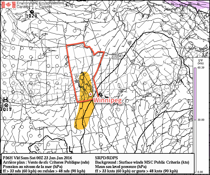
The weather on Wednesday morning will be dominated by a low pressure system and associated warm front that will push through the province Wednesday morning, bringing with it snow, freezing rain and rain to the province. Over western & southwestern Manitoba, precipitation will be a wintery mix of rain, freezing rain and snow. The freezing rain may be fairly intense at times, with total ice accumulations of 2-3mm possible. This will be more than enough to make regional highways treacherous. The freezing rain threat will extend slightly into the southwestern Red River Valley, but will depend significantly on the exact low-level temperature profiles and track of this system. Anyone southwest of Winnipeg in the Red River Valley should stay alert of the potential expansion of freezing rain warnings eastwards.

While light freezing rain is possible throughout the remainder of the Red River Valley, it’s far more likely that the precipitation will fall as snow. To the east of the main band of freezing rain, a swath of fairly intense snow will slump southeastwards overnight and move into the Red River Valley in the morning.

Forecast Sounding for Winnipeg – Wednesday January 27 @ 1400Z
Forecast sounding for Winnipeg early Wednesday morning

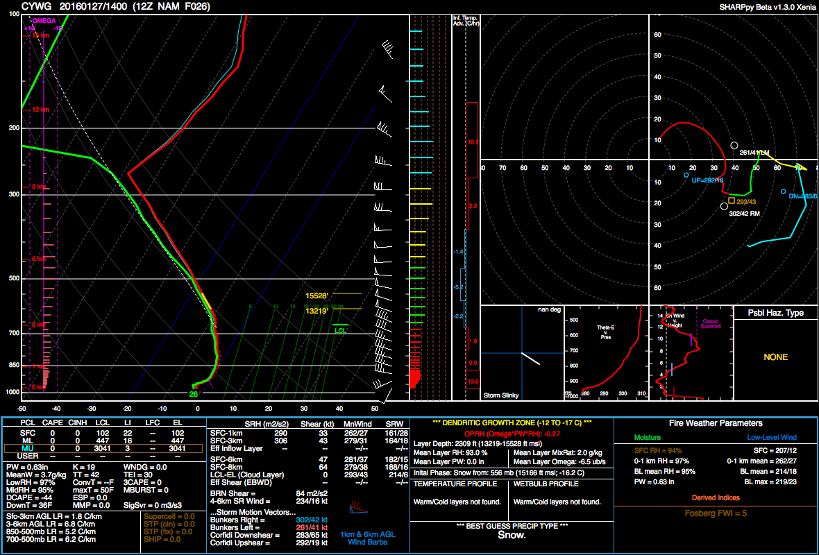
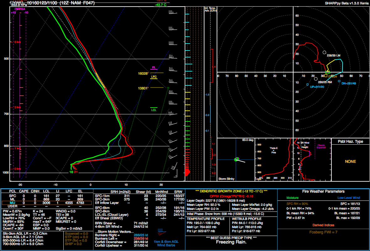
This forecast sounding, which shows the forecasted temperature and moisture profile as you move upwards in the atmosphere, is rather telling regarding heavy snowfall:

  1. First is that there is a deep, deep layer of saturation (shown by the red and green lines being close together. Essentially the entire tropopause is forecasted to be saturated with ample synoptic lift moving in. This will provide plenty of moisture for snow generation.
  2. Also revealing is the moist adiabatic profile[1] throughout the mid-to-upper levels of the atmosphere coupled with the cooler advection occurring aloft. This is a fairly traditional profile that often produces widespread embedded convection within the precipitation area.

These two aspects reveal that intense bursts of snow will be likely with this system, resulting in abruptly reduced visibilities and rapid accumulations. The bulk of the snow is expected to fall between 6 and 9AM, with total amounts of 5-10cm possible in Winnipeg and much of the remainder of the Red River Valley. This will likely result in significant delays in the morning commute as drivers battle slippery roads and poor visibility.

The snow will taper off to flurries for the remainder of the morning and then the next phase of the system sets in…

Mild Weather, But Questionably Nice

Behind the warm front, temperatures will continue to climb in Winnipeg to a daytime high of around 2°C as gustier west-northwest to northwest winds move in. The winds will likely climb all the way to around 40-50km/h, making for not exactly pleasant outside weather. As we climb above 0°C, depending on a few different things, the flurries may either stop or transition to some isolated rain showers.

Heading into the evening, the new dominant weather feature will be a very slow-moving cold front gradually slumping southwards through the province. With ample moisture stuck in place and temperatures dropping back below zero, fog and drizzle/freezing drizzle will begin to become a concern. At this point, it looks like the winds will begin to taper off through the evening, becoming relatively light by midnight or so. Once the winds ease, it’s quite likely cloud bases will begin lowering throughout the region with the risk of fog or drizzle developing. The overnight low will sit around -5°C, so if drizzle materializes, it will do so as freezing drizzle.

Thursday will see the Winnipeg and much of the region stuck underneath that pokey front as it begins to stall and push back to the northeast as the next low pressure system begins developing over the western Prairies. Skies will remain mainly cloudy as a slack flow combines with the weak convergence aloft around the front to keep the moisture socked in over the region. With all that low-level moisture stuck in place, the risk for freezing drizzle and/or fog will also continue. Winds will be fairly light and the high will be around -4°C.

GDPS 6hr. QPF divided by precipitation type.
The GDPS model shows a mix of rain, snow and freezing rain over Southern Manitoba late Thursady night.

The next weather system will begin moving in on Thursday night, spreading warmer air eastwards. As a result, temperatures will climb to around -2°C by Friday morning alongside some light snow and a threat of another round of freezing rain, this one primarily for the Red River Valley.

Winter Mix for Friday

Friday will be another mild day with temperatures climbing to +1 or +2°C in the warm sector of the second disturbance impacting us this week. Freezing rain or snow will taper off to cloudy conditions with a chance of some drizzle. At this point there’s wide discrepancies in how much precipitation will fall through Thursday night and Friday morning, with everything from a relatively minor event to a chance for another 5-10cm of snow.

Late in the day as temperatures cool slightly, some lighter snow is possible. Temperatures will drop to around -1°C on Friday night.

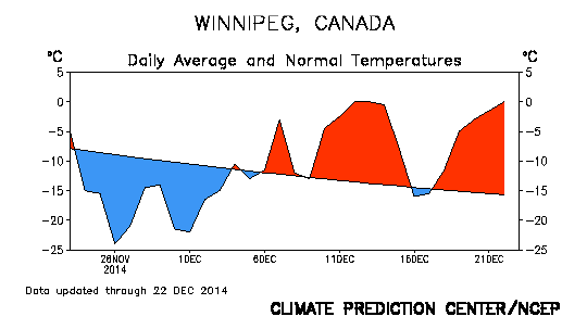
Normal daytime highs for Winnipeg at this time of year currently sit at -12°C with typical overnight lows near -22°C.


  1. Moist adiabatic is the "temperature path"—how its temperature changes—that an imaginary parcel of air will follow as it moves up and down in the atmosphere if it is saturated.  ↩

Windy Transition to Mild Weather

Warmer weather is on the way for the weekend with temperatures soaring close to the freezing mark, however not before a blustery day that will be rather miserable and may impact transportation throughout the Red River Valley.

Windy Weather Developing

Windy weather is on the way for Winnipeg today courtesy a developing low pressure system pushing eastwards across the Prairies. As this system moves towards Manitoba, a strong pressure gradient will develop over the Red River Valley between the incoming low pressure centre and departing ridge of high pressure. As the gradient strengthens in the afternoon, strong southerly winds will develop throughout the Red River Valley.

Strong winds are expected by Friday evening through Southern Manitoba and the Northern Plains
Strong winds are expected by Friday evening through Southern Manitoba and the Northern Plains (the highlighted area).

Sustained wind speeds will increase to 40-50 km/h by the early evening. It seems fairly probable given the near-constant light snow and ice crystals that have fallen over the last several days that blowing snow will become a transportation issue for Friday night into Saturday morning. In Winnipeg it shouldn’t be too bad, but in rural areas, particularly along west-east running highways, the potential for near-whiteout conditions exists. Be sure to give yourself extra time and carry a winter survival kit if you will be travelling on area highways.

Warmer Weather Brings Risk for Freezing Rain or Drizzle

Winds will begin tapering off on Saturday morning as the low pressure system arrives, bringing with it a blast of mild Pacific air. Despite the fact that skies will remain cloudy for most of the day, temperatures will soar to a high of -1°C.

Alongside the surge of warm air will come a risk of some freezing rain. An above-freezing level (AFL) will develop overnight, and by morning an area of precipitation is expected to slide through Parkland Manitoba, the Interlake and northern Red River Valley before sliding eastwards into Northern Ontario.

YWG Forecast Sounding valid Saturday morning from the NAM
This forecast sounding for Winnipeg from the NAM shows a well-defined AFL with Tw ≥ 0°C.

With sustained warm air advection and a wet-bulb temperature above 0°C in the AFL, the potential for organized freezing rain exists. The highest likelihood lies over the Swan River region and then southeastwards through the Interlake. The risk exists over the Red River Valley, but at this point it doesn’t appear that actual amounts will be particularly high. Nonetheless, it doesn’t take much freezing rain to make things slick, so we’ll monitor things and provide an update if the threat for the Red River Valley increases.

Behind the warm front, freezing drizzle will be possible throughout much of the day with saturated low-levels and the lift associated with the incoming low. Winds will be calm through the afternoon.

Winds will shift to the northwest in the evening as a cold front passes through. Skies will remain fairly cloudy and the threat for freezing drizzle will persist well behind the cold front and through much of the night. Temperatures will drop to around -8°C by Sunday morning.

Sunday will bring weak cold air advection through the day, resulting in temperatures rebounding only slightly if at all through the day. The chance for flurries will redevelop as temperature profiles become too cold for freezing drizzle and more favourable for snow. That said, overall moisture supply will be dwindling, so at this point it appears that there will be just a chance for some flurries.

Sunday night will bring cloudy skies and a low near -10°C.

The Christmas Cool-Down

After a prolonged period of temperatures some 10 to 20°C above normal, Winnipeg & the Red River Valley is set for a rude awakening after Christmas as Arctic air plunges southwards and brings below normal temperatures to the region.

This graph of the daily average temperature compared to normal illustrates the dramatic warmth Winnipeg has seen in December.

The crash to colder temperatures will be exceptionally jarring considering the abnormal warmth we’ve seen through much of December. Leading up to Christmas, mild weather will persist as an incoming low pressure system helps extend the stay of the warm air that’s been so common the past few weeks. As the system passes on Christmas Eve, though, a major pattern change is set to take place as our fairly weak is absorbed into the rather major East Coast “Santa Bomb” which in itself will induce a shift to the gradual re-establishment of the Polar Vortex over Hudson Bay.[1]

Christmas Eve

Wednesday
-3°C / -6°C
Cloudy with evening flurries

Today will be a pleasantly mild day with highs near –3°C through the Red River Valley and winds developing out of the south to around 20–30km/h. Skies will remain mainly cloudy in advance of the incoming low pressure system with some flurry activity finally pushing into the Red River Valley by late in the afternoon and reaching Winnipeg by evening. Little is expected as far as accumulations go; the main accumulating snowfall will remain north of the Trans-Canada corridor through the Parkland and Interlake regions eastwards into Ontario where around 2–4cm are expected.

Temperatures will drop to around –6°C tonight with winds shifting to the west-northwest at around 20km/h.
Freezing drizzle will once again be possible overnight into Christmas morning as saturated low-levels are left behind the departing low pressure system. Steep low-level lapse rates and only a relatively light wind from the NW may result in another batch of road-slicking freezing drizzle. Due to its nature, freezing drizzle requires a fairly delicate balance of factors to exist, so there will be unavoidable uncertainty until later tonight, but keep in mind that it is a distinct possibility.

Christmas Day

Thursday
⇒ -5°C / -12°C
Mainly cloudy with scattered flurries

Christmas Day will be a mixed bag in Winnipeg. Temperatures will remain above-seasonal, but the push of cold air will already have begun. As a result, temperatures will likely remain steady near –5°C as any potential daytime heating is offset by the cooler air moving in. Freezing drizzle is possible through the morning hours, while flurries are more likely through the afternoon.[2] Skies will remain mainly cloudy, although a brief glimpse of sunshine is possible.

Temperatures will head down to the –12°C mark or so overnight with a continued chance for flurries and gradually diminishing cloud.

Boxing Day

Friday
⇓ -16°C / -24°C
Mixed skies with a chance of flurries

Boxing day will be when the real surge of Arctic air begins pushing in. Expect mixed skies with a chance of flurries through much of the day. Temperatures will drop through the day to around –16°C by evening. Skies should clear out overnight as the Arctic ridge begins moving in and temperatures drop to around –24°C. This will be the coldest overnight low we’ve had since November 30th into December 1st when the temperature dipped to –27.1°C. Given that the normal overnight low for this time of year is –22°C, that’s not too bad.


Cold Pattern Persists

The cold weather will be here to stay for a while as a persistent northwesterly flow develops over the province thanks to gradually establishing polar vortex over Hudson Bay.

The NAEFS 8-14 day temperature outlook is foreacsting a good chance of below-normal temperatures for Southern Manitoba.
The NAEFS 8–14 day temperature outlook is foreacsting a good chance of below-normal temperatures for Southern Manitoba.

In the end, it means a relatively dry pattern with daytime highs generally in the –15 to –20°C range.[3] This pattern looks to continue at least until late next week, so dig out those real winter clothes again and get the block heater ready, winter’s on its way back.

$.bigfoot()


  1. The persistent vortex over Hudson Bay – for all intents and purposes a “polar vortex” – is a regular occurance over Hudson Bay in the winter months and is the most common cause for prolonged cold weather in Southern Mantioba.  ↩
  2. If things end up just a tad cooler, the freezing drizzle risk could be just a chance of flurries; if things end up a tad warmer, the freezing drizzle risk could persist through much of the day.  ↩
  3. …or a tad cooler.  ↩

Cold Snap Leads Into Another Alberta Clipper

The coldest temperatures so far this season will be settling in for a short stay in Southern Manitoba before a powerful series of clippers move across the Prairies at the end of the week, bringing what may become one of the most potent winter storms seen so far this winter.

Wednesday
-18°C / -30°C
Mainly sunny
Thursday
-17°C / ⇑ -14°C
Increasing cloudiness
Friday
-10°C / -13°C
Chance of flurries

The deep freeze settles over Manitoba today as a potent high pressure system moves in from Northern Saskatchewan, bringing with it a fresh shot of Arctic air. Temperatures will warm to around -18°C from the mid-minus-twenties present this morning under mainly sunny skies. Tonight will bring the coldest temperatures of the season to Winnipeg and the Red River Valley with overnight lows dropping dangerously close – or even just below – the -30°C mark. Tonight’s record low for Winnipeg is -36.1°C set in 1891, so some solace can be had knowing it’s been colder.[1]

Tomorrow will see the cold air exit the region as a major system making landfall in British Columbia begins pushing warmer air eastwards across the Prairies. Temperatures will be on their way up, up, up with a daytime high near -17°C followed by a rising temperature trend overnight that brings temperatures up to around -14°C by Friday morning. While Thursday will start off clear, cloud will start spreading into the Red River Valley sometime midday or into the afternoon, with things becoming completely cloudy sometime in the evening.

Some light snow is possible on Thursday night along a mid-level trough in the region. While more consistent snow is likely over southwestern portions of the province, here in the Red River Valley little is expected in the way of accumulations. We’ll keep an eye on it, but it looks like amounts will remain less than 2cm in any activity that develops.

Friday Brings Winter Storm to Portions of Manitoba

Friday will likely be a bit of a mess of a day…somewhere. A potent low pressure system will track eastwards near the international border, spreading an area of snow ahead of it and another area of snow to its north. It’s really too early to make too many accurate predictions other than a whole host of weather being possible on Saturday. Some areas of the Red River Valley will likely see some snow while a more organized snow event occurs (once again) through Parkland Manitoba eastwards through the Interlake and into the Berens River Region. There’s simply too much uncertainty with the track and strength of the low at the moment to create a snowfall forecast; it looks like a possible snowfall warning event will occur through the Interlake[2] while lesser amounts track along and south of the Trans-Canada corridor. We’ll be making a snowfall forecast graphic a little closer to the event when we can have more confidence in the amounts.

Just one of many model solutions, the GDPS shows lighter precipitation amounts (just 2-5cm of snow, generally) in Southern Manitoba from Friday morning to Saturday morning.

On Friday evening, temperatures will continue to rise with southerly winds into the mid-minus single digits, but then the low will pass and the winds shift around to northwesterly at 30-40km/h. Ample low-level moisture coupled with an incoming – and very dry – 50kt jet at 700mb may result in some freezing drizzle or snow grains overnight. The northwesterly winds will bring in substantially colder air with temperatures dropping to around -12 or -13°C after the evening rising trend.

Colder Air Returns for the Weekend

Saturday will bring clearing skies as another ridge of high pressure moves into the province. Temperatures will only recover slightly from Friday’s overnight low thanks to a fairly breezy northwesterly wind before dropping into the mid-minus 20’s on Saturday night under clear skies. Sunday looks sunny with a high in the low minus teens and calmer winds.


  1. Words of minimal comfort, I know.  ↩
  2. Environment Canada issues snowfall warnings when accumulations of ≥ 10cm are expected in a 12 hour period.  ↩