Springtime Roller Coaster Sets up Over Southern Manitoba

Temperatures will be all over the place this week as a series of low pressure systems draw warmth north and drive cold air south.

RDPS 2m Temperature Forecast valid 12Z Tuesday March 11, 2025
An Arctic high will bring cold temperatures to southern Manitoba on Tuesday morning.

It’ll be a frigid start to the week with temperatures down into the -20s across southern Manitoba this morning. An Arctic air mass settled into the region overnight behind the cold front of the clipper system that brought a fresh coat of snow to the region yesterday. Fortunately, the cold won’t be here for long as the Arctic high responsible for it quickly shifts towards eastern Canada.

Temperatures will rebound back into the -10 to -5 °C range this afternoon with southerly winds picking up into the 20 to 30 km/h range. Much of the day should bring sunshine, but skies will cloud over in the evening. Another low pressure system will slump through the province into North Dakota tonight. It will keep temperatures from dropping much overnight and bring another dusting of snow to the region. The snow should begin sometime after supper and taper off overnight. Snowfall amounts by Wednesday morning should be less than a centimetre or two.

The weather for the rest of the work week will be defined by two features: an upper ridge building into the Prairies and a deepening upper trough on the west coast.

The building upper ridge will bring milder temperatures back to the region with daytime highs climbing to around the +5 °C mark on Wednesday. As a bonus, Wednesday should bring sunny skies with southwest winds in the 15 to 25 km/h range.

By Wednesday evening, a well-developed warm front will lie draped from the southwestern Prairies into North Dakota. A weak impulse will track along it on Wednesday night, bringing more cloud and light snow. There will be a risk of freezing rain overnight as warm air continues to stream north over the warm front through the night. At this point, it is not expected to be a widespread concern but we could see slippery areas on Thursday morning from overnight freezing rain.

Temperatures will dip down into the -5 to 0 °C range on Wednesday night with northeast winds picking up into the 20 to 30 km/h range.

RDPS 2m Temperature Forecast valid 21Z Thursday March 13, 2025
Thursday could bring warm weather to southern Manitoba.

Skies will clear out on Thursday as the deepening upper trough over the west coast begins to drive the development of a large low pressure system in the United States. The temperature forecast is tricky for the day as there are disagreements as to whether the warm front over the region will stay roughly in place or lift north. If winds stay northeast, daytime highs will likely reach a degree or two above 0 °C. If the region can switch to easterly or southeasterly winds, then much warmer weather is possible.

Long Range Outlook

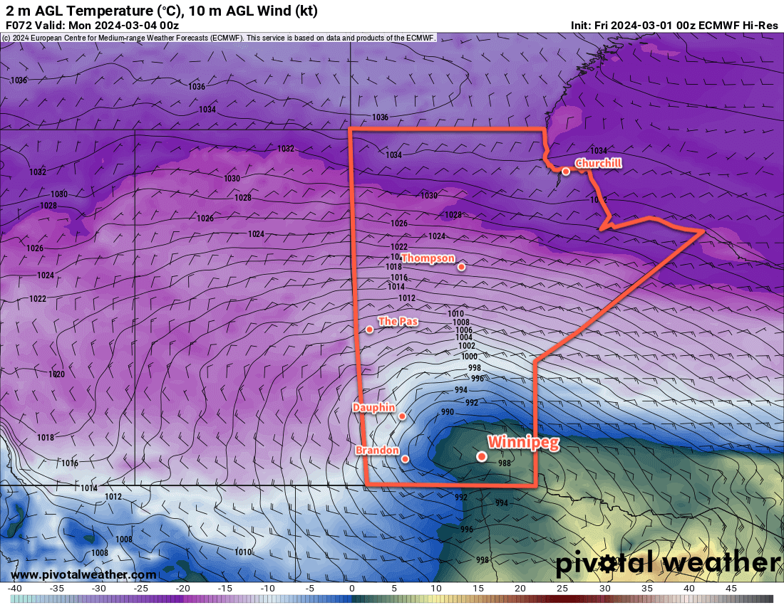
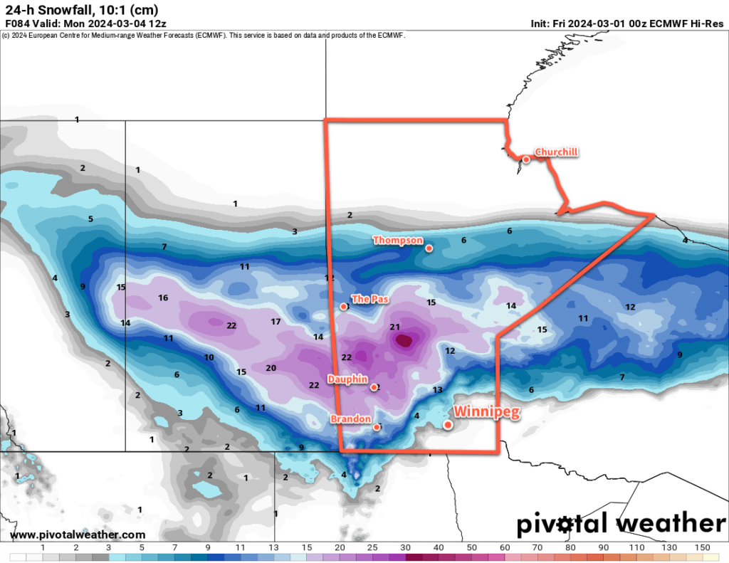
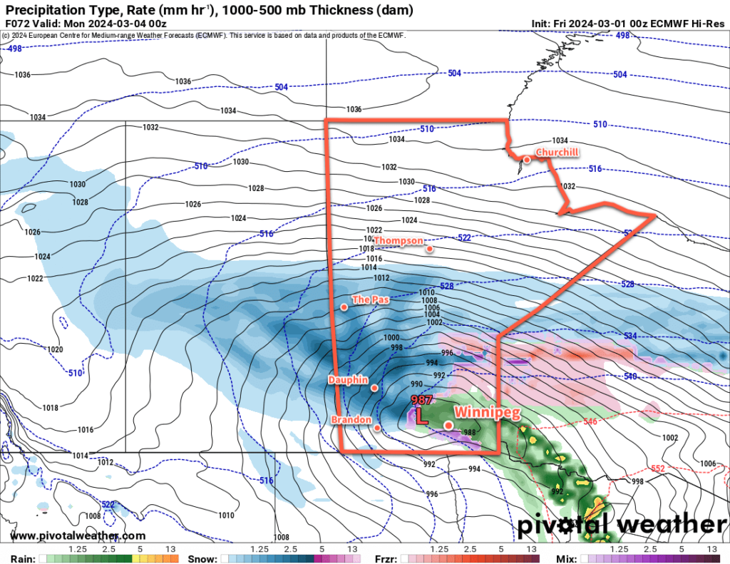
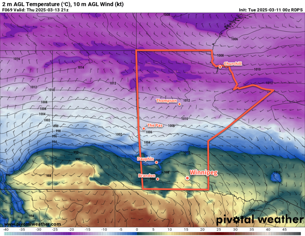
Heading into the end of the week, the broad story is clear, but the details are impossible to discern at this point. As the upper trough begins to dig east towards the American Plains, a potent Colorado Low will develop and begin to lift northeast on Friday. A warm front will be driven northeast through southern Manitoba as warm air surges north. Daytime highs of 15 to 20 °C will be possible over northern Minnesota, but temperatures in the Red River Valley will likely reach the 5 to 10 °C range. As the warm air pushes north, cold air will dig in from the northwest; heading into western and southwestern Manitoba, daytime highs may not even break the freezing mark.

This system will spread multiple waves of precipitation north over a couple days, and almost anything could be possible: heavy rain showers, freezing rain, broad areas of rain, snow, and ice pellets. This system will bring strong northerly winds on its western flank with much colder weather digging into the region later on Saturday.

At this point, it looks like much of this system’s precipitation will track east of the Red River Valley but forecasting the track of Colorado Lows more than a few days out can be a futile effort. There is the chance that this system’s track could shift east and end up missing our region…or that its track shifts west and the Red River Valley experiences the brunt of this system.

Be prepared for the potential for a major storm this weekend with all sorts of wintery weather possible, and hope for the best!

Colder weather will settle into the region for Sunday as the temperature drops into the minus teens on Saturday night and rebounds towards the -10 to -5 °C range.

Warmer weather will build back in for next week with daytime highs climbing back above freezing.

Today’s seasonal daytime high in Winnipeg is -2 °C while the seasonal overnight low is -13 °C.

Weekend Storm to Bring Wintery Mix to Southern Manitoba

A winter storm moving into the province on Sunday will bring a mix of wintery weather to southern Manitoba.

ECMWF 2m Temperature Forecast valid 00Z March 4, 2024
A potent winter storm will move into southern Manitoba this weekend, but Winnipeg may be spared from the worst of it.

Before the storm arrives, though, it will be a pleasant start to the weekend in Winnipeg. Temperatures will climb above freezing today as a low pressure system crosses through central Manitoba. It will drag mild Pacific air across the south, sending daytime highs into the 5 to 10 °C range through the Red River Valley.

Breezy southerly winds up to 30 gusting 50 km/h this morning will ease midday as Winnipeg moves into the warm sector of this system. The region will see mixed skies develop this afternoon, followed by more organized cloud cover as a cold front slumps into the region tonight. As the cold front moves into the region, northwest winds will pick up into the 20 to 30 km/h range and then ease overnight. Temperatures will dip to a low near -10 °C.

Saturday will bring mixed skies to the region as the next weather system to impact the region begins to take shape. Northeast winds will pick up into the 20 to 30 km/h range as a low centre begins to develop in the Northern Plains of the United States. Skies will cloud over through the day with light snow possible by the late afternoon or evening.

Temperatures will climb to a high near -5 °C by the evening and continue to rise to the freezing mark by Sunday morning. The snow will taper off overnight, leaving behind a couple centimetres, and be replaced with a risk of freezing drizzle into Sunday morning.

On Sunday, the low centre will lift out of the United States and into Southern Manitoba. This system impact the entirety of southern Manitoba and bring adverse winter storm conditions to many regions. In the sake of brevity, here’s what to expect for each weather element.

Heavy Snow

This low pressure system will spread an area of heavy snowfall across southern Saskatchewan and into southern Manitoba. Because this low will bring a surge of warm air into the Red River Valley and SE Manitoba, there is uncertainty as to how far east the heavy snow will reach.

ECMWF 24-hour Snowfall Accumulation (10:1 SLR) Foreacst valid 12Z Monday March 4, 2024
This storm will spread heavy snow through Saskatchewan into western and central Manitoba. There is uncertainty to how far southeast the notable snow accumulations may push.

That said, through southwest Manitoba, Parkland Manitoba, and much of the Interlake, this system will bring 15 to 35 cm of fresh snow. Amounts will taper off gradually into central Manitoba and sharply into the warm sector of above-freezing air.

Freezing Rain

This system will support a band of freezing rain that develops along its advancing flank and will likely cut across the Red River Valley and SE Manitoba. Note that this risk area could shift west or east over the coming days as the system takes shape. That said, the risk of freezing rain will begin early Sunday and persist through the day. Freezing rain across southern Manitoba will come to an end on Sunday evening as the low begins to track east and colder air sweeps into the southeast corner of the province.

ECMWF Precipitation Type Forecast valid 00Z Monday March 4, 2024
This storm will bring a mix of wintery precipitation to southern Manitoba.

Rain

To the east and south of the freezing rain band, temperatures will warm enough for any precipitation that falls to fall as rain. This will include much of SE Manitoba but could push as far west as Winnipeg and north as Lake Winnipeg. Rainfalls totals could reach as high as 5 to 10 mm, but much more of the precipitation should fall on the cold side of the system as snow.

Additionally, there are early signals that as the cold front wraps around this low, convective cells may develop along the rain band associated with it. A few rumbles of thunder and heavier rain showers can’t be ruled out close to the U.S. border late Sunday into the evening.

A Guess for Winnipeg?

In Winnipeg, it looks like a risk of freezing rain on Sunday morning will transition to light rain, and then to periods of snow in the afternoon as cooler air moves in. There is significant uncertainty with this, though, and even a 50 km shift in storm track could end up changing the forecast to 10 to 20 cm of snow. On the other hand, if the storm ends up 50 km further west, much of the Red River Valley, Winnipeg included, could be in this storm’s dry slot and see little beyond a couple waves of light snow or rain and a lot of drizzle.

Be sure to keep an eye for updated forecasts as the event draws near. If you’re in SW or Parkland Manitoba, be prepared for poor conditions on Sunday as a notable winter storm moves through the region.

Long Range Outlook

Light snow will taper off across central Manitoba on Monday. There may be a small chance of flurries in Winnipeg on Monday, but the activity should stay mainly to the north. The first half of next week will be cooler with highs in the -10 to -5 °C range.

Another low pressure system will slice its way northwards through Manitoba mid-week; it will bring another chance of mixed precipitation to the province and bring milder weather back to the Red River Valley and areas east.

Today’s seasonal daytime high in Winnipeg is -5°C while the seasonal overnight low is -15 °C.

Colorado Low Poised to Bring Fresh Snow to Manitoba as Warm Weather Continues

Cloudy skies, mist/fog, drizzle, and mild temperatures will continue for a couple more days in the Winnipeg area. The weather will finally change across southern Manitoba on Wednesday night as a Colorado Low begins to spread waves of precipitation into the province.

ECMWF Precipitation Type Forecast valid 18Z Thursday February 8, 2024.ECMWF Total Accumulated Snowfall Forecast (10:1 SLR) valid 00Z Saturday February 10, 2024.
Waves of mixed precipitation will move into southern Manitoba on Thursday. This Colorado Low will bring accumulating snow to most of southern Manitoba.

The next couple days in Winnipeg will bring more of what the city has seen lately: plenty of cloud, mist and fog patches, and occasional drizzle. A ridge of high pressure moving across the Red River Valley will keep things stagnant with light northerly winds. The trend of temperatures well above normal will continue with highs a couple degrees above freezing and lows right near the freezing point.

Then, the most notable weather system in weeks will begin to impact the region on Wednesday night. As I mentioned in Thursday’s post, long-range models were developing a Colorado Low-like system and pushing it quickly eastwards. I mentioned that I wouldn’t be surprised to see this system pull further west as it approached and…that’s what has happened with the forecast models over the past few days.

A Colorado Low will eject northeastwards on Wednesday, reaching South Dakota by Thursday morning and then into Minnesota by Thursday evening. As it draws closer to Manitoba, it will begin to spread waves of precipitation into the province. The first couple waves, arriving Wednesday night and Thursday morning could bring a wintery mix of snow, rain, and freezing rain to the Red River Valley. As those move off to the northwest, the region will see a break with cloudy skies and a chance of drizzle.

By later Thursday, northerly winds will strengthen across the region and begin to draw cooler air into the region. More snow will be possible Thursday evening through much of Friday before it finally tapers off.

There is a wide range of snowfall accumulations possible with this system, and at this point there is significant uncertainty as to where the axis of heaviest snow will set up in the province. In general, many areas of the province will receive 5 to 10 cm of fresh snow, with 10 to 20 cm possible in the swath of highest accumulation. Amounts could creep even higher on the northern slopes of the Turtle and Riding Mountains where northerly winds enhance the snowfall along the terrain.

With the notable uncertainty that remains with how this system will set up over the province, I recommend you check the updated forecasts on ECCC’s weather website over the coming days.

Daytime highs in Winnipeg will fall into the -5 to 0 °C range by the end of the week with overnight lows in the -20 to -10 °C range depending on how much clearing is able to move into the region.

Long Range Outlook

The weekend will bring cooler — but still above normal — temperatures to the region. Daytime highs will dip to around -5 °C with lows dependent on how cloudy the nights stay. With clearing, lows could drop into the -20 to -15 °C range, but if it stays cloudier then lows could hover near -10 °C.

Hopefully the region will see a bit of sun this weekend, but there’s a chance things do stay on the cloudier side.

Next week will continue the trend with daytime highs near -5 °C and overnight lows in the -10 to -20 °C range as light westerly winds develop over the region.

Today’s seasonal daytime high in Winnipeg is -10 °C while the seasonal overnight low is -21 °C.

Wintery Mix of Snow, Freezing Rain, and Rain Possible on Sunday in Southern Manitoba

A slow-changing weather pattern over Winnipeg will continue to bring daytime highs near the freezing mark and mixed to cloudy skies. By Sunday, though, an approaching low could bring a wintery mix of snow, rain, and freezing rain to southern Manitoba.

RDPS 2m Temperature Forecast valid 21Z Sunday November 5, 2023
Temperatures will hover near or above the freezing mark over the next few days.

Today will start with some cloud moving through the Red River Valley as a weak front slumps into the region. In its wake, light northerly winds will accompany clearing skies. Some cloud will persist through the day as lake-effect flurries stream off lakes Manitoba and Winnipeg, but the wind direction should favour them flanking Winnipeg rather than moving through the city.

Temperatures will climb up to a high around 0 °C today, then dip to a low in the -5 to -10 °C range tonight.

Heading into the weekend, warmer air will attempt to build into the region. Rather than seeing any notable warm-up, as it often is this time of year, the region instead will be blanketed in cloud. Winds will shift southerly and ease further on Saturday with cloudy skies in the Red River Valley. The remnants of a collapsing low pressure system could bring some light snow to the region on Saturday afternoon.

On Saturday night, a low pressure system developing in Alberta will eject eastwards across Saskatchewan. Winds in the Red River Valley will shift eastwards overnight in response along with a low chance of some light snow. Temperatures will only drop a few degrees from Saturday’s daytime high.

On Sunday, a wintery mix of precipitation will push into Manitoba ahead of the approaching low in Saskatchewan. The day will likely start with some rain and/or freezing rain spreading through southern Manitoba while snow pushes through the Parkland into the Interlake. As the day progresses, the freezing rain will diminish while the rain/snow line lifts northwards. Daytime highs should reach around +2 °C on Sunday afternoon.

RDPS Forecast Precipitation Type/Rate valid 18Z Sunday November 5, 2023
Southern Manitoba may see a wintery mix of precipitation on Sunday, including freezing rain.

By the end of the day, the low centre will cross through the Red River Valley, followed by northerly winds and the rain/snow line collapsing southwards as the precipitation tapers off overnight. The freezing rain potential in southern Manitoba will largely be confined to the morning, and while conditions could be poor while it’s occurring, the subsequent climb above freezing with temperatures should limit the longevity of its impact. If you have plans to travel on Sunday morning, be prepared for adverse travel conditions and be sure to check highway conditions before leaving.

Long Range Outlook

Temperatures will stay comparatively mild next week with daytime highs likely creeping to the positive side of freezing through the week. Some flurries will be possible, but the next organized precipitation event will likely be with a low pressure complex moving through the region mid-week.

This system could bring another wintery mix of precipitation to southern Manitoba as it passes through.

Don’t expect to see the sun too much; skies will be mainly cloudy this week. Some more organized sunshine could begin to move back into the region in the latter half of the week.

Today’s seasonal daytime high in Winnipeg is +3 °C while the seasonal overnight low is -6 °C.