Warmer and Unsettled Weekend Ahead

Temperatures will finally push towards seasonal values this weekend as a warmer air mass pushes into Southern Manitoba from the Western Prairies. Daytime highs are set to climb into the mid-single digits which will bring the warmest temperatures since March 14th of this year when we managed to struggle our way to +4.0°C. Tagging alongside the milder temperatures will be unsettled conditions with multiple chances for precipitation through the next few days.

Friday

Friday
0°C / -5°C
Mainly sunny.

Today will be quite a pleasant day with mainly sunny skies and a high near 0°C. A ridge of high pressure will keep the winds light through the day as well. There may be a few cloudy periods this morning as we clean out any remnant cloud from yesterday’s system, but otherwise there should be plenty of sunshine.

Later today will see the approach of a warm front tied to a low pressure system tracking through the northern Prairies. Winds will increase out of the south to around 30km/h tonight as the warm front approaches. Thanks to the wind and some cloud pushing in later in the night, we’ll drop to only around -5°C.

Saturday

Tomorrow has the potential to be a bit of a messy start to the week. The warm front will be pushing it’s way through early in the day, bringing with it the potential for some snow or freezing rain.

Winnipeg forecast sounding for Saturday morning from the NAM.

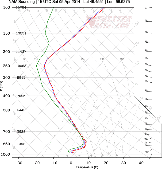
This forecast sounding shows the development of a small layer of above-freezing air (AFL) above a below-freezing layer of air at the surface. The AFL doesn’t look very deep, so freezing rain is far from a sure thing as the balance between melting snow and reinforcement of warm air will be a delicate one dependant on how intense the precipitation is.

Saturday
7°C / -5°C
Cloudy with chance of flurries or freezing rain in the morning, then clearing.

Depending on whether or not the precipitation manages to build far enough south to reach the Red River Valley is the primary unknown; if it does reach us then there’s a chance it will fall as freezing rain instead of snow. Whatever it decides to fall out of the sky as, though, it will be fairly short-lived and confined to the morning.

After the warm front pushes through in the morning, skies will begin to clear up and the temperature will begin climbing towards a high of 6 or 7°C. Saturday will be the warmest day in Winnipeg since the temperature hit 10.3°C on November 13th last year. Winds look to be light through the day.

Temperatures will drop to around -5°C once again on Saturday night with light winds.

Sunday

Sunday
3°C / -9°C
Mainly sunny.

Sunday will be a slightly cooler albeit still pleasant day. Winds will be relatively light out of the south as we head to a high temperature of 3°C. An incoming low pressure system will spread cloud into the Red River Valley late in the day and bring a chance of some flurries through the evening and overnight periods.

All in all it will be a fairly pleasant weekend without too much wind and some mild temperatures. Aside from a few brief chances for precipitation, it might actually feel quite spring-like out there! Enjoy!

Elsewhere in Weather News: February 8th, 2014

Massive Ice Storm Paralyzes Slovenia

A massive ice storm crippled a large part of the Central European country of Slovenia earlier this week. Freezing rain accumulations of 100mm wrecked havoc, encasing all unheated surfaces in a thick layer of ice. The ice brought down power lines, fell trees, and froze vehicles in place, leaving at least 50,000 houses without power at one point. Slovenian authorities estimate that the storm caused at least $89 million in damages and destroyed 40% of Slovenia’s alpine forests. The pictures coming out of Slovenia from this event are extraordinary:


  • A car encased in ice
    A car encased in ice.
  • A man chips the ice off his car in Postojna, Slovenia
    A man chips the ice off his car in Postojna, Slovenia.
  • Forests were severely damaged by the ice storm.
    Forests were severely damaged by the ice storm.
  • Road signs coated in a thick layer of ice.
    Road signs coated in a thick layer of ice.

Freezing rain is a common weather phenomena, but for it to occur on this scale is rare. In most situations, freezing rain occurs ahead of a warm front as warm, above-freezing air overrides a shallow layer of below-freezing air near the surface. As snowflakes fall through that warm above-freezing layer they melt into rain drops. This allows it to rain, since those rain drops don’t have a chance to refreeze before hitting the surface. However, once this rain strikes the surface, it freezes instantly, forming a layer of ice. Usually the warm front that causes the freezing rain will be moving, preventing the freezing rain from sitting over one area for a prolonged period of time. However, in some situations the warm front will stall out, or move parallel to an area, causing freezing rain to persist for an extending period of time. In the case of Slovenia’s ice storm, it appears a slow moving weather pattern allowed the freezing rain to sit over the same area for an extended period of time, generating the large ice accumulations seen above.

Sources:

http://www.businessinsider.com/photos-of-ice-storm-in-slovenia-2014-2

http://www.washingtonpost.com/blogs/capital-weather-gang/wp/2014/02/07/craziest-ice-storm-photos-youll-ever-seen-from-slovenia-photos/

Elsewhere in Weather News: February 1st, 2014

Southeast US Paralyzed by Storm

On Tuesday a large trough was in place over the eastern half of the US. The longwave trough extended all the way down to the southeastern states and brought adverse weather conditions along with it. This trough did not produce the typical severe weather the southeast would see around this time of the year; thunderstorms and flooding rain, but produced an event featuring snow, ice pellets and freezing rain.

Arctic air flooded in behind the cold front all the way down from Texas to the Gulf of Mexico to Florida, providing good environment for freezing precipitation right behind the front. Freezing rain fell as far south as Pensacola in the Florida panhandle where over 200km of interstate had to be shut down because it was deemed to be too dangerous for travel. The last time Pensacola saw snow was 2010 – it melted the same day it fell. In comparison, Atlanta saw a trace of snow in 2008. This time around the city received 6cm, which snarled traffic on the commute back home. Officials decided to not cancel schools and students were stranded in schools and buses overnight until the next morning. Commuters were in the same situation, being stranded on roads overnight as many commuters are not accustomed to winter weather leading to many accidents. The sub-freezing temperatures across the Deep South also wreaked havoc, bursting water pipes above ground.

Wednesday morning surface temperatures. Freezing temperatures can be seen reaching all the way down into Mexico and the Deep South. (Source: Twisterdata)

Medium range models continue to show cold air entrenched across the Canadian Prairies and most of the United States, even infiltrating into the Deep South again next week. A persistent ridge off the West Coast, partially associated with the well above normal temperatures in the North Pacific, can be blamed for the persistent troughing and Arctic air over Canada and US the past few weeks. Longer range models do show the ridge eventually breaking down in a week but this remains to be seen as it’s still a long ways out.

Mid-January Storm To Bring All Manner of Nasty Weather

A powerful storm system is pushing into Southern Manitoba this morning and will become the first major storm of the year. This storm will impact the entirety of Manitoba and bring very strong winds, heavy snow, near-blizzard conditions and a good chance of some freezing rain. Read on to find out where will see what as we break this thing down.

  • Significant weather expected: strong winds (and blowing snow), freezing rain and heavy snowfall.

  • Expected storm-total snowfall amounts from this system.

Disclaimer: I could write many more words than I have time to write about this system. As such, I’m going to just explicitly state right now that while I may mention areas outside the Red River Valley, the focus of this post will be for the weather expected in Winnipeg & the Red River Valley.

We’ll start out with the good news: temperatures are expected to stay near or above normal[1] through the remainder of the week; no horribly cold Arctic air is expected to slam southwards into the Prairies with this system. That’s about where the good news ends, though.

As we progress through this morning, an area of snow will move into the Red River Valley, pushing in from the west ahead of the incoming warm front. The low pressure centre is currently in northeastern Saskatchewan and will begin to dive southeast into Central Manitoba later this morning. Winds will strengthen out of the south this morning up to around 40-50km/h with gusts as high as 70km/h. Despite the relatively mild temperatures – we’re sitting at around -10°C – extensive blowing snow will likely be an issue in areas to the south of Winnipeg[2] thanks to the strength of the winds.

Wednesday

3°C / -11°C
Snow beginning this morning. Very windy. Risk of freezing rain this afternoon. Flurries overnight with blizzard conditions in the Red River Valley.

The heaviest snowfall will pass to the north and east of the city where a heavy snowfall warning is in effect for 10-15cm of snow. Here in the Red River Valley we’ll see a fair gradient in snowfall amounts from the southwest corner to the northeast corner thanks to how the precipitation spreads in from northwest to southeast. Through the day today, areas in the southwest corner can expect the lighter end of the snowfall with only around 2-5cm accumulation by the evening. Here in Winnipeg we’ll see from 5-10cm of snow while closer to 10cm of snow will fall to our north and east.

Our winds, as mentioned before, will become quite strong out of the south. They’ll lighten a little bit for the early afternoon as they swing to the west as the low pressure system moves through the Interlake and the warm front pushes east of the Red River Valley. Our temperature will jump up to around +2 or +3°C and we’ll see a break in any blowing snow that’s happening. By mid-to-late afternoon, though, a cold front will be approaching. Winds will shift a little more to the northwest and we’ll see a risk for some freezing rain just ahead of and along the cold front as it pushes through. In addition, there is the potential for some fairly heavy bursts of snow along the cold front with some models hinting that there may be a fair amount of convective activity associated with it[3]. Winds will shift straight out of the northwest by the evening and strengthen considerably to 50km/h with gusts potentially as high as 80km/h overnight here in Winnipeg.

This wind will readily whip up the freshly fallen snow in the RRV and produce near-zero or white-out conditions on area highways. Despite the fact that temperatures will not drop too quickly – only to around -10°C overnight – it will still be a brutal night. Continued flurry activity will likely continue through the night, compounding the visibility problems presented by the winds alone.

Thursday


⇒ -10°C / -20°C
Windy with blowing snow. Mainly cloudy.

The snow will taper off early on Thursday, but poor visibilities will continue through much of the day as the strong northwest winds persist at 40-50km/h at least into the early afternoon. Temperatures will remain fairly steady at around -10°C.

By evening the wind will taper off as a ridge of high pressure moves into the province, bringing an end to any blowing snow left in the Red River Valley. The clouds will also scatter out and we’ll drop to a chilly -21°C for our overnight low.

Friday & The Weekend


-10°C / -14°C
Cloudy periods with a chance of afternoon flurries.

Friday will start off sunny but some cloudy periods will develop as a warm front pushes into the Red River Valley. We’ll become overcast in the mid-to-late afternoon and see a chance for a few flurries as the warm front pushes eastwards. This front will usher in warmer air for the weekend with highs near the 0°C mark and overnight lows dropping just shy of around -10°C.


  1. Normal daytime highs are around -13°C for mid-January.  ↩
  2. As usual, with a southerly wind the highways that will be affected most are those that run west/east.  ↩
  3. As evidenced by lightning in Northern Alberta last night.  ↩