Elsewhere in Weather News: June 14th, 2014

Western Europe Sees Severe Storms

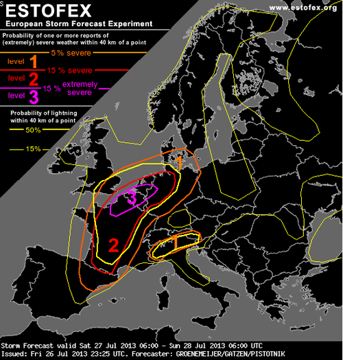
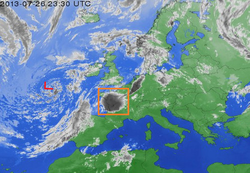
It has been quite an active pattern to start off this past week across Western Europe. The pattern favoured severe weather and brought numerous modes of it to the region, including very large hail and damaging winds. A trough of low pressure was sitting just offshore, over the Atlantic Ocean, with a ridge over most of Europe advecting in warm, moist air to the region. As the upper level trough shifted further east, a surface low pressure over the North Sea, with a cold front extending southwards, also pushed east into a very unstable atmosphere setting up for a severe weather outbreak. Sunday through Wednesday all offered severe weather opportunities across the region.

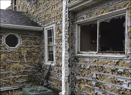
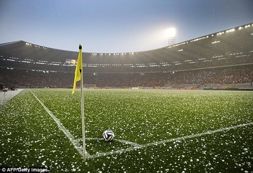
Last Sunday night a severe thunderstorm hit Brussels bringing with it large hail. Hail the size of ping pong balls could be seen littering the city which postponed a World Cup exhibition game that was being played in the city. On Monday night, a completely different storm affected parts of Germany. A powerful bow echo raced across the country bringing winds as high as 142km/h in Düsseldorf, one of Germany’s largest cities. Numerous other reports over 100km/h were reported with the bow echo. Significant damage was reported with trees uprooted by the straight-line winds which also contributed to six deaths in the country.

Hail littering the soccer field in Brussels (Source: AFP/Getty Images)
Radar capture of the bow echo the raced across Germany. (Source: MeteoGroup)

Since then, calmer weather has moved into the region with more of a northwest flow aloft and colder temperatures. No severe weather is expected in Western Europe this weekend.

Elsewhere in Weather News: June 7th, 2014

Large Hailstorm causes Millions in Damages

This past week featured severe thunderstorms that tore through the Nebraska countryside producing extremely large hail in the region. Conditions were primed for a severe weather outbreak this past Tuesday; moisture streamed up from the Gulf of Mexico, a strong jet streak was in place overhead and the environment was relatively uncapped. Convective Available Potential Energy (CAPE) was quite high that day which was a significant contributor to the large hail sizes observed. Generally the higher the CAPE, the faster the updraft velocity which means that the updraft can support larger hailstones. Supercell thunderstorms were triggered Tuesday afternoon and persisted through the evening, trailing along the warm front that bisected the region.

In total over 200 hail reports were submitted on Tuesday and of these 38 were considered large hail reports (hail of 5cm in diameter or larger). The most damage caused that day appeared to come out of the town of Blair, Nebraska where hail caused major damage. Windows were blown out and car windshields smashed by the baseball size hail that fell – damage totaled in the hundreds of millions. Other storms along the warm front, the weather feature that triggered the severe weather, moved into the Omaha area not only bringing hail, but also torrential downpours. 13.5mm of rain was recorded in 3 minutes at the Omaha airport!

Hail damage in Hoover, NE shows the strength of baseball size hail, completely shredding the siding and breaking the windows. (Source: Kevin Krohn)

There is a possibility for more severe storms this weekend in Texas and New Mexico, but the parameters are not as as favourable for severe weather as seen this past Tuesday in Nebraska. Models show the active pattern continuing in the US Plains into next week, and rightfully so as severe weather season nears its peak.

Elsewhere in Weather News: July 27th, 2013

France Faces Severe Storms; More Coming Today

France has had its fair share of severe storms this past week, with more of it expected to come today (Saturday). A level 3 “severe” thunderstorm, the highest risk possible, has been issued by ESTOFEX (European Storm Forecast Experiment) for the northern half of France. Conditions are favorable for tornadoes with a warm front draped across the region and incoming cold front from the west; an upper-level low spinning off the coast of France over the Atlantic will provide sufficient destabilization in the upper levels of the atmosphere.

ESTOFEX forecast

ESTOFEX forecast for today, risk 3 in northern France, Belgium, Netherlands and northwest Germany. Highest risk for large tornadoes resides here. (Source: ESTOFEX)

The only potential flaw in the setup could be due to the large MCS that fired up on Friday evening in west-central France as it continues to move northeast potentially leaving debris cloud in the region this morning. But with that said, as of Friday evening, the MCS was moving fairly quickly, and at this rate would be out of the region in time for tomorrow’s setup. With dewpoints in the low twenty Celsius range, shear plentiful with the approaching upper-level trough, and a great shear profile, all kinds of severe weather could be in play, including powerful tornadoes. The severe weather risk also extends into northwest Germany, Belgium and the Netherlands.

MCS and upper level low

Upper level low spinning off the coast of France and MCS in orange box that could hinder storm activity tomorrow. Infrared satellite image taken Friday evening. (Infrared satellite image source: Weather Online)

The expected severe weather follows a significant weather outbreak that occurred in France on Tuesday afternoon. Strong storms passed through the Burgundy region dropping large hail (between ping-pong and golf ball size) and causing significant damage to vineyards. In this region, crop losses are as much as 75% in the hardest hit areas. Flooding was also an issue, where some main roads such as the one between Pommard and Volnay were flooded out and impassable.

In 2008 an EF-4 tornado touched down around Hautmont, France and caused 4 fatalities and 18 injuries. Severe weather is not that common of an occurrence in France, with only a couple outbreaks per year.

Stormy Start to the Long Weekend

The August long weekend will be off to a stormy start today as the threat of severe thunderstorms bears down on the Interlake, Red River Valley and Whiteshell this afternoon.

Tornado near Lake Diefenbaker

One of a couple of tornadoes that the incoming system spawned in Saskatchewan yesterday. Photo by @TheMrsCogs.

A very powerful low pressure, responsible for at least two tornadoes in Saskatchewan yesterday, will move into Southern Manitoba today and push a cold front across the province through the day. Very strong dynamics will accompany this system, a stark contrast from the last few systems which have had comparatively strong thermodynamics instead. Despite the lack of strong thermodynamic parameters that are often looked at when diagnosing severe thunderstorm potential, such as CAPE, EHI or LIs, the strong dynamics will present a significant severe weather threat over south-central and southeast Manitoba.

Dynamics are physical, kinematic properties of the atmosphere, such as jets, shear and lift. Thermodynamics are thermal/energetic properties of the atmosphere such as temperatures, humidity and instability.

A band of showers will push into the western Red River Valley early in the afternoon ahead of the upper low. As the afternoon progresses, the upper low will begin to deepen and enhance the destabilization over the Red River Valley. By mid-to-late afternoon, despite the cool temperatures and cloudy skies, there should be rapid development of storms along the cold front. Tornadoes are unlikely, although not impossible, here in Southern Manitoba; that threat should be relegated to the Dakotas where even greater dynamics and substantially better thermodynamics are present. If any tornadoes do form tomorrow, it’s likely that they will be of the short-lived variety and relatively weak. The greatest threat from today’s storm will be extremely heavy rain giving rapid accumulations of 1-2” (25-50mm) given precipitable water values of 40-50mm and large, damaging hail given the cool temperatures aloft.

Thunderstorm Outlook

Day 1 thunderstorm outlook valid 18Z today through 12Z tomorrow morning.

The storms will exit the province overnight, and we’ll have a brief reprieve from precipitation. On Saturday, some showers will wrap down into the RRV on the back side of this system. Amounts will vary across the region, but in general less than 5mm is expected. Temperatures will struggle to climb to even 20°C; daytime highs of only 18 or 19°C are expected. Winds will be breezy from the NW.

This system will clear out Saturday night before nicer weather builds back in. The second half of the long weekend will see increasingly sunny skies and daytime highs near 25°C.