Pleasant Start to the Weekend

After a few days that threatened storms for the Red River Valley, we’re heading out the other side with most communities seeing little to no rain. Steinbach is a notable exception, with over 100mm of rain falling1 through a rather unusual rainfall event early Wednesday morning which produced significant overland flooding2.

24hr. Precipitation Totals valid Sunday Evening

24 hour accumulated precipitation from Friday Saturday evening to Sunday evening.

A pleasant start to the weekend is ahead, with no chance of showers until Saturday evening and overnight. Today we’ll see mainly sunny skies as our temperatures rebound from yesterday’s system up to a high near 26°C. The overnight low tonight will be around 15°C. Warmer air pushing in aloft will allow temperatures to climb higher on Saturday and Sunday, with daytime highs close to 30°C expected. Humidity will remain relatively low for Saturday, however things may get a little uncomfortable on Sunday as dewpoints begin to climb closer to the 20°C mark.

On Saturday a disturbance entering the province will generate some showers and thunderstorms over SW Manitoba through the late morning and afternoon hours. The (thunder)showers will spread eastwards through the evening and overnight, however it’s currently looking like the bulk of precipitation will occur through the Interlake. The northern half of the Red River Valley looks to have a decent chance of seeing some sort of precipitation, however the odds look very slim that the southern half will see anything.

We’ll see increasing cloud Sunday afternoon as the back side of this system prepares to swing through Sunday night. As it does, there will again be a chance of showers for Winnipeg and, as it looks now, the eastern RRV. We’ll be sure to provide updates in the comments as this system approaches.

new TWTR.Widget({
version: 2,
type: ‘list’,
rpp: 30,
interval: 30000,
title: ‘July 2nd, 2012’,
subject: ‘AWM Storm Chase’,
width: ‘auto’,
height: 500,
theme: {
shell: {
background: ‘#3c3c3c’,
color: ‘#eeeeee’
},
tweets: {
background: ‘#eeeeee’,
color: ‘#2c2c2c’,
links: ‘#489ce1’
}
},
features: {
scrollbar: true,
loop: false,
live: true,
behavior: ‘all’
}
}).render().setList(‘WeatherInThePeg’, ‘awm-team’).start();

Dog Days of Summer

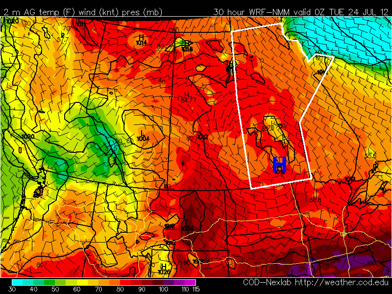
The weather has been very warm so far this July and there is no sign of this pattern changing any time soon. The dog days of summer are in full swing.

A surface high pressure system will help keep the weather warm and calm through Monday and Tuesday

A surface high pressure system will help keep the weather warm and calm through Monday and Tuesday

Temperatures on Monday will remain warm, but will be fairly comfortable. High temperatures in Southern Manitoba will generally be in the upper twenties with low humidity. Tuesday should be a bit warmer than Monday, with highs near thirty degrees, but once again humidity levels will remain relatively low. By Wednesday the humidity will rise ahead of an approaching trough of low pressure. At this time it appears that there may be a risk of severe storms on Wednesday afternoon and evening in the Red River Valley and South-Eastern Manitoba as this trough runs into a hot and humid airmass. However, the timing of the front is still a bit uncertain, and the speed at which is moves will determine which areas are at risk for storms on Wedensday.

At this point you can probably predict what next weekend has in store…yes you guessed it, more hot weather. It looks like we may be lucky enough to get one cooler day on Thursday, with high temperatures close to normal (i.e. in the mid twenties) before we heat up again for the last weekend of July.

Hot to Really Hot Weather on the Way

Southern Manitoba will quickly heat up to be extremely hot for the later half of this week, while any rain/thunderstorms will remain fairly elusive through the Red River Valley.

You might need one of these on Thursday...

You might need one of these on Thursday.

A strong thermal ridge will start pushing it’s way into Manitoba toady with 850mb temperatures of 22-24°C. This will really crank up the heat over the Red River Valley. Today will be our coolest day over the next few days, with temperatures “only” climbing to 27°C with light winds from the north. There will be some clouds around today and a very slight chance of a shower or two late this afternoon as the warm front starts pushing into Southern Manitoba. Winds will shift to the south overnight tonight, with a low around 18°C.

The southerly wind should help clear the air of any haze and smoke that’s remaining in the Red River Valley, which will allow the full power of the sun to help cook the atmosphere on Thursday. 850mb temperatures will climb towards the mid-20’s, which will help surface temperatures easily climb into the mid-30’s. Two uncertainties exist to the daytime high:

  1. Moisture. The higher the dewpoint is, the more energy it takes to heat it up. That makes it harder to reach really high temperatures when the dewpoints are high than when the air is dryer. For Thursday, the NAM currently predicts dewpoints to be right around 20°C, the GFS pumps dewpoints up to nearly 25°C, and the GEM has them right around 22°C.
  2. Wind direction. Winds will be southerly to start the day, however a weak trough pushing across the RRV should start to shift the winds to southwesterly. When a southwesterly wind is in place over the RRV, it helps to increase daytime highs by a few degress as the wind downslopes over the western escarpment and heats up a little bit. The air often drys out a bit in this process as well, which aids in helping the temperatures increase a bit.

Should the moisture end up being on the lower side and we do get a southwest wind in place over the the RRV, temperatures could potentially shatter our previous hottest day of the year. Models indicate temperatures of 37-40°C are possible over the southern RRV, while temperatures of 34-37°C can be expected over the northern RRV. I’d be very hesitant to say we’re going to hit 40°C in Manitoba on Thursday, especially with dewpoints in the 20’s. It will certainly be an extremely hot day, and when the temperature and the dewpoint are taken into consideration, widespread humidex values of 40-45 will be seen across Southern Manitoba with the potential for isolated spots to see even higher values. Either way, it’s almost certain we’ll see temperatures at least in the low-to-mid 30’s over the RRV, with humidity making it feel much closer to the low 40’s.

Things will cool off a bit on Friday as some less-warm air filters in aloft. 850mb temperatures are expected to drop to a more modest 15-20*deg;C, which will cap daytime highs to “only” 30 or 31°C. Dewpoints should also be a good 3-5°C lower, making it a slightly more comfortable day.

There’s a slight chance of a shower or thundershower on Thursday evening over the more northern portions of the Red River Valley, although any activity will likely stay in the Interlake region. Our chances for showery weather increase into the weekend as cooler air beings to inflitrate it’s way in aloft while down here at the surface we remain near the nose of a thermal ridge. Highs will remain in the high 20’s through the weekend.

Hot Weather Continues

More warm to hot weather is expected for this week. Our hot spell continues…

The sun

You’ll be seeing a lot of this again this week.

High temperatures through the first few days of the week are expected to be in the mid to upper twenties in Southern Manitoba. No irriguous weather is in the forecast for this period, save for perhaps some rain this morning from a passing thunderstorm complex and a chance for some more showers late this afternoon and through the evening as a bit of cooler air filters southwards on the back-side of the low exiting the province today.

As we move into late week models hint at the potential for another heat wave. The generally accepted definition of a heat wave in North America is three or more consecutive days with high temperatures of 32C or greater (90F or greater). Temperatures of this magnitude may be possible from Thursday through Saturday of this week. In addition, dew points are expected to rise through the latter half of this week, which when combined with the hot temperatures will produce humidex values in the low-to-mid 40s! Since this forecast extends fairly fair into the future weather-wise, it may change somewhat as the week progresses.

As has been the case for much of the last month, long range modelling shows no end in sight to our hot weather. It looks like July should end just as it started – HOT!