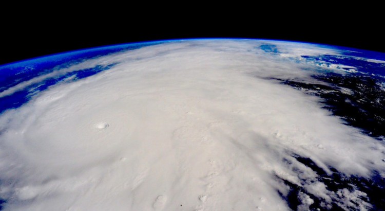
Hurricane Patricia from the ISS. © Scott Kelly (Twitter: @StationCDRKelly)

Patricia Breaks Western Hemisphere Records, Makes Landfall in Mexico

On the 20th of October a tropical depression formed in the Eastern Pacific, well south of Mexico and began drifting slowly northwest into an area of warm sea surface temperatures (SST’s) of about 30°C with low shear.

[map type=”terrain” autofit=”1″ disable_scrollwheel=”1″] [pin]Cuixmala[/pin] [pin tooltip=”La Manzanilla”]Selva de Melaque[/pin] [pin]Puerto Vallarta[/pin] [/map]

Typically hurricanes of this strength are not seen this late in the Eastern Pacific, but very warm SST’s were still present in the area – perhaps influenced by the strong El Niño that is ongoing, provided the fuel necessary for a hurricane of this strength. After drifting northwest without significant intensification early in the week, Thursday is when Patricia began intensifying as it produced a large burst of convection. Patricia intensified to a rate the Western Hemisphere had not seen before – it dropped an incredible 100mb within 24 hours, and at the same time Patricia reached category five status which is the highest category on the Saffir-Simpson scale.
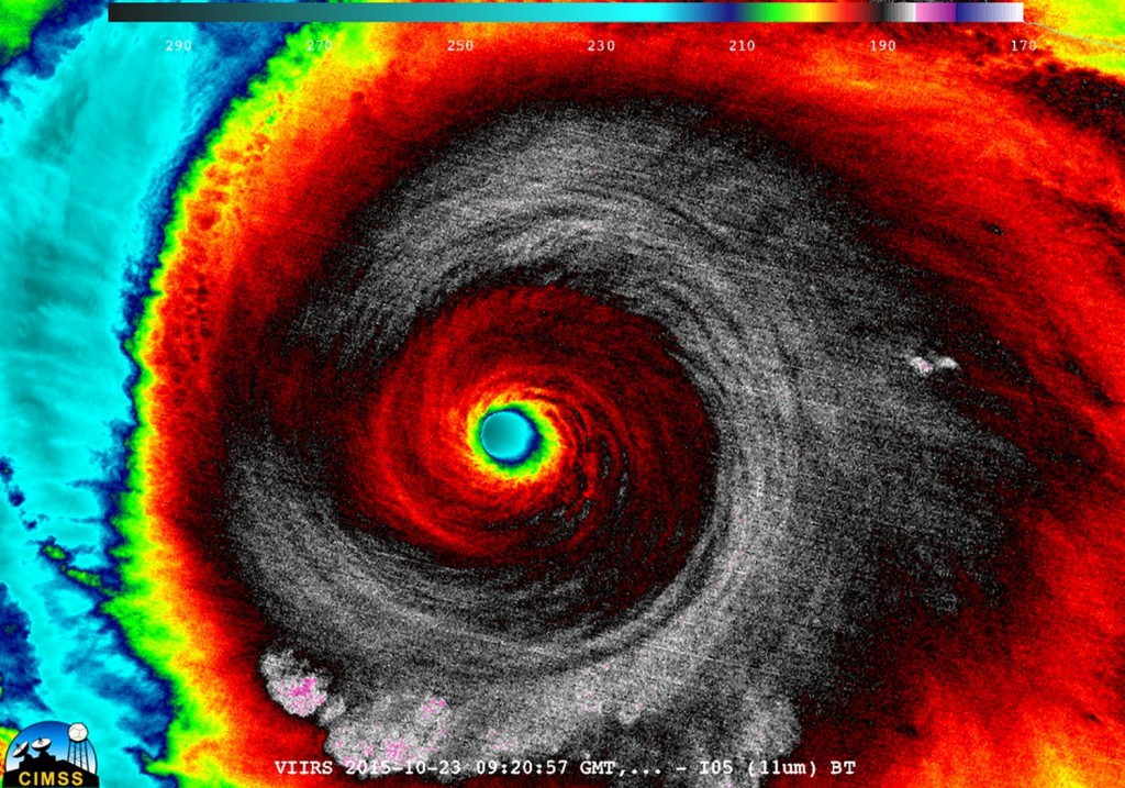
Enhanced IR image of Patricia early Friday morning. (Source: CIMSS)

As it neared its peak early Friday morning, the hurricane hunters flew through the hurricane to sample the environment. The data collected was astonishing; a drop sonde had measured a surface pressure of 883mb with a 45kt surface wind. From this they extrapolated that the central pressure of Patricia was about 879mb at the time of the drop sonde, breaking another Western Hemisphere record for lowest pressure observed. Winds also peaked in Patricia around the same time, where sustained winds were 325km/h, with possible gusts up to 400km/h. Thankfully Patricia’s wind field did not extend very far from its core because it was a fairly compact inner core with pinhole eye – hurricane force winds only extended about 40km from the centre of the storm.
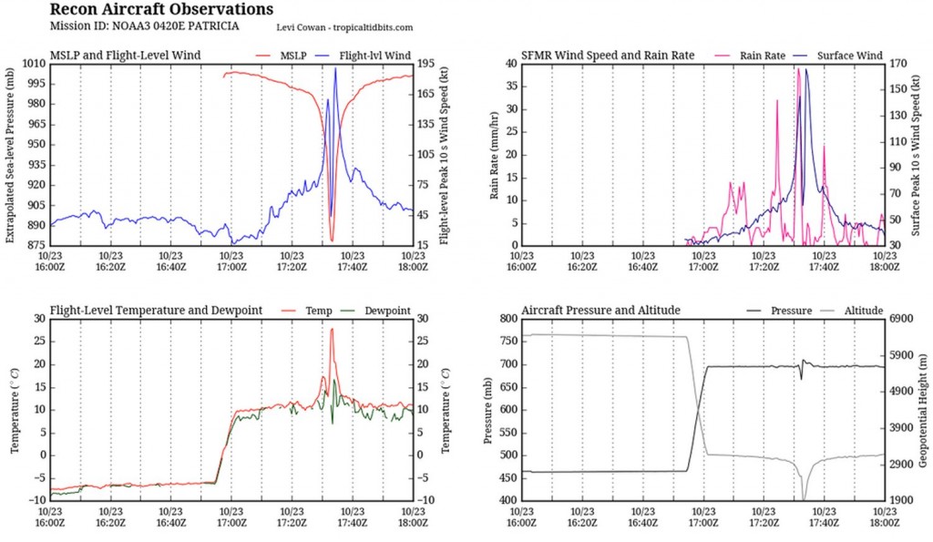
Aircraft data collected Friday morning from the Hurricane Hunters. To note is the top left graph which measured a very low extrapolated MSLP as well as the extremely high winds at aircraft level. In the bottom left graph it's also to note the steep rise in temperature (of about 15C in the eye - the result of subsiding air warming. (Source: @tropicaltidbits)
Aircraft data collected Friday morning from the Hurricane Hunters. To note is the top left graph which measured a very low extrapolated MSLP as well as the extremely high winds at aircraft level. In the bottom left graph it’s also to note the steep rise in temperature (of about 15C in the eye – the result of subsiding air warming. (Source: @tropicaltidbits)

What’s it like flying into one of the strongest ever observed? Here’s a video of the Hurricane Hunters flying in Patricia:

Patricia made landfall as a category five hurricane southeast of Puerto Vallarta, near Cuixmala on Friday evening. Thankfully no deaths had been reported yet out of Mexico as of this morning but significant damage occurred along the coast near La Manzanilla which was both a result of storm surge and the strong winds. After encountering land and terrain Patricia’s inner core quickly collapsed and the system’s biggest threat has now shifted to heavy rainfall. Patricia’s moisture plume is expected to move northeast, helped by an upper level trough, across the Sierra Madres and into southeast Texas. A dangerous flash flooding event is ongoing this weekend in Texas with all the tropical moisture combined with a source of lift present.
Northern Hemisphere Waters Seeing Increased Storm Activity

The hurricane and typhoon seasons (Atlantic and Pacific basin, respectively) both ramped up this past week as three significant storms spun up with another one expected to strengthen.

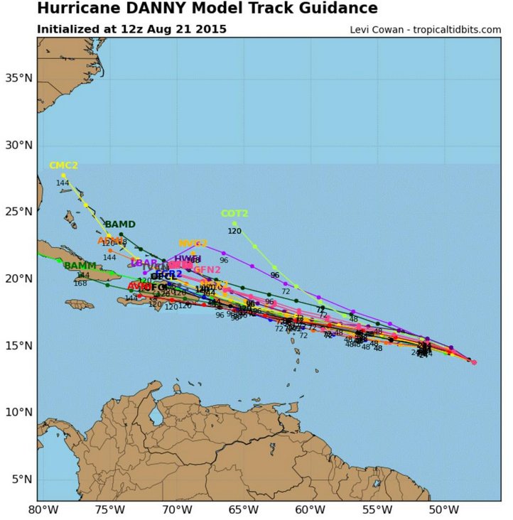
Different model tracks for Danny - some models want to curve it northwards faster than others. (Source: Tropical Tidbits)
Different model tracks for Danny – some models want to curve it northwards faster than others. (Source: Tropical Tidbits)

The first, hurricane Danny, formed a few days ago west of Cape Verde Islands, in the Atlantic basin. The conditions in the past days were good for steady intensification, until about Friday midday when the hurricane encountered dry air and began ingesting it. Before then however, a recon plane flew into Danny and registered winds that suggested the storm was already a major hurricane, of category three on Friday morning. This is the first major hurricane of the Atlantic this year and the earliest since 2009. As Danny is still far from the US mainland it is impossible to say which states it will affect, if any at all. Before then however, it is expected to move through the northern Antilles, but only as a tropical storm due to the fact that it will continue to gradually weaken due to high shear/dry air present east of the Antilles.

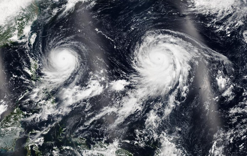
Two typhoons are also currently spinning simultaneously in the western Pacific, one off the western coast of Thailand (Goni), and one further west (Atsani). These were both once very powerful typhoons, of category four and five (super typhoon), respectively. They have since gradually weakened to category two equivalent storms however. Neither of them are expected to make direct landfall, but Goni has already had adverse effects on the northern Philippines and Thailand, bringing heavy rain and fairly strong winds as it brushed the islands. What is special about these two very powerful storms (category four and higher) was that they were churning in the western Pacific simultaneously, a feat that is fairly uncommon.

Beautiful satellite image taken on the 20th that captures both Goni and Atsani in the western Pacific. (Source: NASA)

Finally, the last storm of concern is tropical depression Kilo, located southeast of the Hawaiian Islands. As of Friday night Kilo was only a weak storm with sustained winds of 60km/h. However, Kilo is expected to continue curving northwestwards towards the Hawaiian Islands and strengthen. National Hurricane Centre is forecasting that it will strengthen to a category two hurricane and could come very close to making landfall on the island of Kauai. There’s still some uncertainty of its exact track this far out but it appears that this will be a major event for at least the western Hawaiian Islands.

Eastern Pacific Active Season Starts Early

The Eastern Pacific hurricane season is off to a record breaking start this year as hurricane Blanca formed south of the Baja Peninsula last week and meandered north towards it. Blanca finally made landfall early this past week on the Baja Peninsula; this is the earliest in the season that a hurricane has ever made landfall on the peninsula since records began.

[map autofit=”1″ disable_scrollwheel=”1″] [pin tooltip=”Baja California Sur” description=”24.101633, -110.632324″]24.101633, -110.632324[/pin] [pin tooltip=”Tropical Disturbance Formation Area”]15.427206, -103.469238[/pin] [pin]Puerto Vallarta[/pin] [/map]

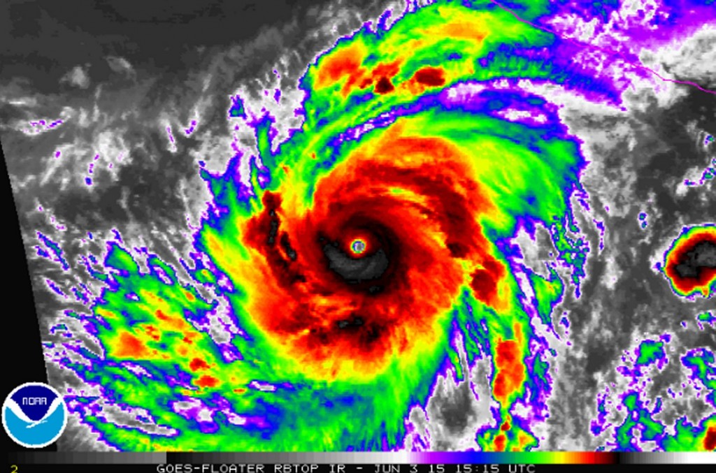
Hurricane Blanca initially struggled with too much shear tearing the storm apart while it was organizing about 1000km southeast of the Baja Peninsula, but as it slowly drifted north, the environment became more favourable for development.  The storm quickly formed an eyewall and became a category four hurricane. After an eyewall replacement and cooler waters churned up from the stormy seas, Blanca weakened to a category one. However, not too long after, it restrengthened to a category four. By the time the hurricane approached the Baja Peninsula it had encountered cooler waters and slowly weakened to a tropical storm.

Hurricane Blanca with a well defined eye on June 3rd.  (Source: NOAA)
Hurricane Blanca with a well defined eye on June 3rd. (Source: NOAA)

Although the storm was only classified as a tropical storm when it made landfall, bringing winds of 75km/h, the outages it caused were fairly significant. It caused 105,000 of the peninsula to lose power, and brought storm surges of about 5m to areas near the resort town of Puerto Vallarta, on the eastern shores of Mexico. In addition to that, the storm brought significant rainfall in the order of 75-150mm across the Baja Peninsula.  A few days ago, the storm transitioned into a depression over the southwest US and produced some rains over the drought-stricken state of California.

Yet another storm has formed this past week southwest of the Baja Peninsula – hurricane Carlos. Although this one did not strengthen to a category four like Blanca did, there is a chance that it brings another significant rainfall to the Baja Peninsula as a tropical storm by mid-week next week. The storm season for the East Pacific officially starts May 15th.

Elsewhere in Weather News: October 18th, 2014

Gonzalo Rolls through Bermuda

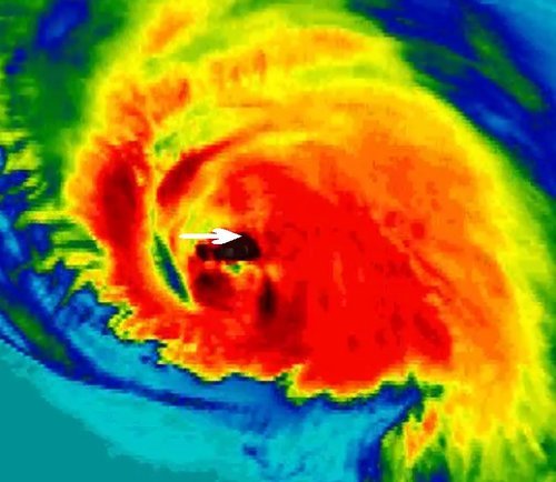
Another week, another tropical disturbance forms – this time in the Atlantic. Gonzalo started to organize earlier this week just east of the Caribbean and drifted west, slowly organizing itself at the same time. By the time it reached the eastern islands of the Caribbean such as Anguilla and the British Virgin Islands, Gonzalo was a category one hurricane and brought strong winds and heavy rains to the islands. Hurricane Gonzalo then started curving northeast and quickly strengthened into a category four, with a pinhole eye after it cleared the Caribbean Islands. The storm was then headed for Bermuda, which meant trouble for the small island out in the Atlantic.

Deep convection in the northern eye wall of Gonzalo depicted by the black colors. Bermuda is identified by the white arrow.

Gonzalo made landfall on Bermuda Friday evening, lashing Bermuda with high end category two winds (175km/h) as the eye wall made its way across the island. Reports of how Bermuda fared were difficult to find as of Friday evening, but it appears the island did quite well with no deaths or injuries reported. However, power was knocked out to about 90% of Bermuda’s residents as well as flooded streets reported. Compared to last week’s EIWN, the big difference is that the infrastructure in Bermuda is built to withstand fairly strong hurricanes, unlike most of the buildings in the region of India that Hudhud affected.

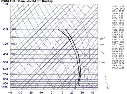
The Bermuda Weather Service launched a weather balloon as the eye approached Bermuda at 00z. (Source: University of Wyoming)

Hurricane Gonzalo will continue its trek northeastwards and may even clip Newfoundland by Sunday as it transitions to extratropical. Interestingly enough, Gonzalo will likely make it all the way to the United Kingdom as an extratropical storm early next week. No other storms are expected in the near future in the Atlantic.