Elsewhere in Weather News: September 20th, 2014

Odile Makes Landfall

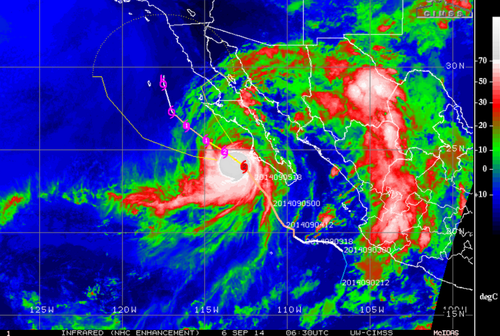
The active Eastern Pacific hurricane season that was discussed in the EIWN post a few weeks ago continues to produce – another major hurricane was spun up this week. This time it was hurricane Odile, a category four at its maximum strength, which bottomed out at a pressure of 922mb. This hurricane, however, headed towards the Baja Peninsula and made landfall there as a category three hurricane on Sunday night.

Odile just as it was making landfall on the tip of the Baja Peninsula. (Source: NOAA)

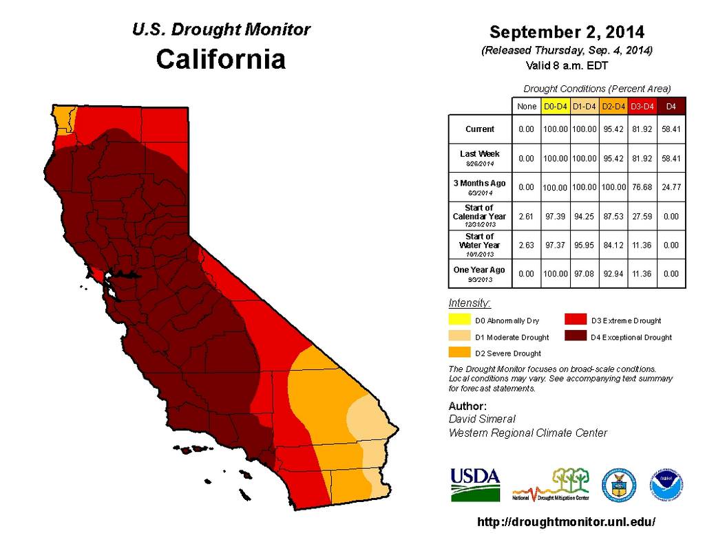
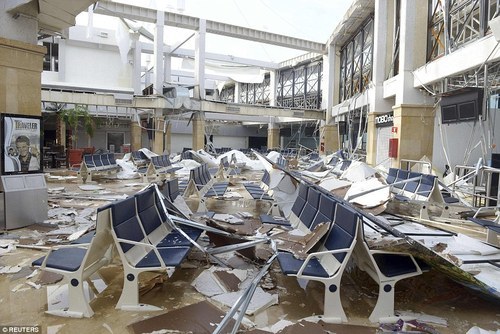
Cabo San Lucas was one of the resorts hardest hit as Odile brought winds of 205km/h upon landfall. As expected with a hurricane of this magnitude, significant damage was done to infrastructure as well as three deaths were reported. About 240,000 residents lost power during the event prompting school closures and flight cancellations; causing major headaches to travellers in the popular tourist destination. Odile eventually weakened into a tropical storm as it made its way further north, interacting with terrain and beginning to get torn apart by shear. Even though Odile had weakened substantially, the storm was not done causing trouble to people in the US Southwest, bringing with it its plume of tropical moisture. Reports of flooded houses and washed out roads were coming out of southern New Mexico and Arizona on Thursday and Friday where as much as 100mm fell in some towns (Sept. average rainfall is around 30-50mm in the region). Streams quickly became rivers and one resident perished as he got swept away by the floodwaters. It’s not all bad news to the US Southwest though, as drought continues to improve in the region.

Damage at the Los Cabos Airport. (Source: Reuters via Dailymail)

There’s already another storm; Polo, churning in the East Pacific but it is not expected to take the same path as Odile did. No other tropical storms are expected to impact the Baja Peninsula in the near future.

Elsewhere in Weather News: September 6th, 2014

East Pacific Continues to be Active

This past Tuesday the 10th hurricane in the Eastern Pacific formed and slowly strengthened into a category two hurricane and remains at this status as of Friday night. The hurricane, Norbert, is not expected to make any landfalls, however it is scraping by the Baja Peninsula region bringing adverse weather conditions to the region. Tropical destinations along the coast such as Cabo San Lucas saw tropical storm warnings as well as hurricane warnings. Norbert’s tropical storm force winds expanded a good distance from its centre which prompted these warnings. In fact, Cabo San Lucas had sustained winds of 98km/h overnight Thursday and combined with strong outer rain bands, this made for nasty conditions.

IR image of Norbert on Friday night. (Source: CIMSS)

Norbert is expected to slowly continue northwest to its death and stay offshore. One potential benefit is that the remnants of Norbert could help a bit with the drought in California. The tropical plume of moisture should hold together and has the potential to move into southern California next week, making a small dent in the significant drought that is occurring:

The entire state of California is currently in one of the worst droughts on record. Almost 60% of the state is considered to be in exceptional drought.
The entire state of California is currently in one of the worst droughts on record. Almost 60% of the state is considered to be in “exceptional drought.”

The Eastern Pacific hurricane season lasts from mid-May to the end of November and on average features 8 hurricanes. In contrast to the Eastern Pacific hurricane season, the Atlantic hurricane season has been off to another slow start with only 3 hurricanes this year with no real prospects of possible storms in the near future according to the models, even as we approach the peak of the season. The Atlantic sees on average six hurricanes every year.

Elsewhere in Weather News: August 8th, 2014

Multiple Hurricanes and Typhoons in the Pacific

The Pacific Ocean has been busy lately and continues to impress this past week with four different tropical cyclones simultaneously ongoing.

GOES image of Julio, the beginnings of Genevieve, Iselle and Halong (in the top left corner). Taken earlier this week; storm intensities have since changed. (Source: NASA)

The first, typhoon Halong (formerly super typhoon, talked about in last week’s EIWN), is closing in on Japan’s main islands and is forecast to make landfall later this afternoon. Shikoku will be hardest hit; here Halong will make landfall with sustained winds of 120km/h – the equivalent of a category one hurricane.

The second is super typhoon Genevieve. This storm is unusual in such that it was formerly known as hurricane Genevieve – it has since crossed the International Dateline and is now classified as a typhoon. This is the first tropical cyclone to have done this since 2006. Thankfully Genevieve is in the middle of the Pacific and is not expected to make landfall any time soon.

Hurricane Julio is the third tropical cyclone in the Pacific. This one is forecast to pass just north of the Hawaiian Islands. The outer bands of the hurricane are still expected to affect the islands by bringing heavy rains to the now-saturated soils of Hawaii – soils saturated courtesy of the next storm: Iselle.

Tropical storm Iselle is the fourth and has had the biggest impact on American soils. The tropical storm made landfall on the Big Island of Hawaii yesterday and brought with it high end tropical storm force winds combined with copious amounts of rain (over 100mm). Interestingly enough, this is the first time a tropical storm has hit Hawaii since 1992 and the first time since 1952 that one has made landfall on the Big Island. Recovery efforts are still underway with a significant amount of damage to trees and homes on the island. Thankfully, this storm has not been responsible for any injuries or deaths so far.

Elsewhere in Weather News: July 12th, 2014

Atlantic and West Pacific Oceans See Storms

Hurricane Arthur
The beginning of July started off on an active note as hurricane Arthur spun up just off the coast of Florida. Arthur quickly organized, pushing out the dry air that was initially a problem on the northwest side of the storm. Following the short bout with the dry air, Arthur formed a well-defined eye. The storm “only” reached category two as it made landfall on the Carolina coast near Cape Lookout, shortly after forming the well-defined eye. It brought with it sustained winds of 160km/h, whipping up a significant storm surge as high as 1.4m on the outer banks.

Base reflectivity radar image of Arthur shortly after it made landfall on the outer banks of North Carolina very early on July 4th. (Source: GRlevel3)

In the aftermath of the storm 41,000 residents from North Carolina had lost power, in addition to some minor damage to houses. Flooding was also a concern where a few areas received over 100mm of rain from the storm. Thanks to much warning in advance, no residents were injured or killed with this storm. Arthur brings an end to the lull in hurricane activity the United States has seen in the past couple years. The last hurricane to have made landfall in the United States prior to Arthur was in August, 2012.

Arthur further continued its trek up the East Coast bringing miserable weather to the US Northeast as well as Atlantic Canada, but was less of a threat (still significant) as a post-tropical storm.

Super Typhoon Neoguri
Super typhoon Neoguri was another significant storm that spun up to start off the month of July, this time in the western Pacific Ocean. With the help of very warm sea surface temperatures as well as little shear to tear it apart, Neoguri strengthened to a super typhoon producing sustained winds of 250km/h and bottoming out at a pressure of 930mb. Six deaths have been attributed to Neoguri as well as over 100 injuries. After passing through the Ryuku Islands, Neoguri got caught up in the polar jet stream and curved back east towards Japan as it started its transition to an extratropical storm over Japan. Satellite observations indicated rainfall totals of over 500mm in a few mountainous regions of Japan. Neoguri was officially declared an extratropical storm yesterday.

Another disturbed area is currently over the Pacific and is expected to become of tropical storm strength this weekend, however, is not expected to impact any landmasses in the near future.