India Faced with Intense Heat Wave

A heat wave has taken hold across much of India in the past few weeks and will continue to do so before monsoon season arrives next week.

[map autofit=”1″ disable_scrollwheel=”1″] [pin]Bhubneshwar[/pin] [pin]Andhra Pradesh[/pin] [pin]Rajasthan[/pin] [/map]

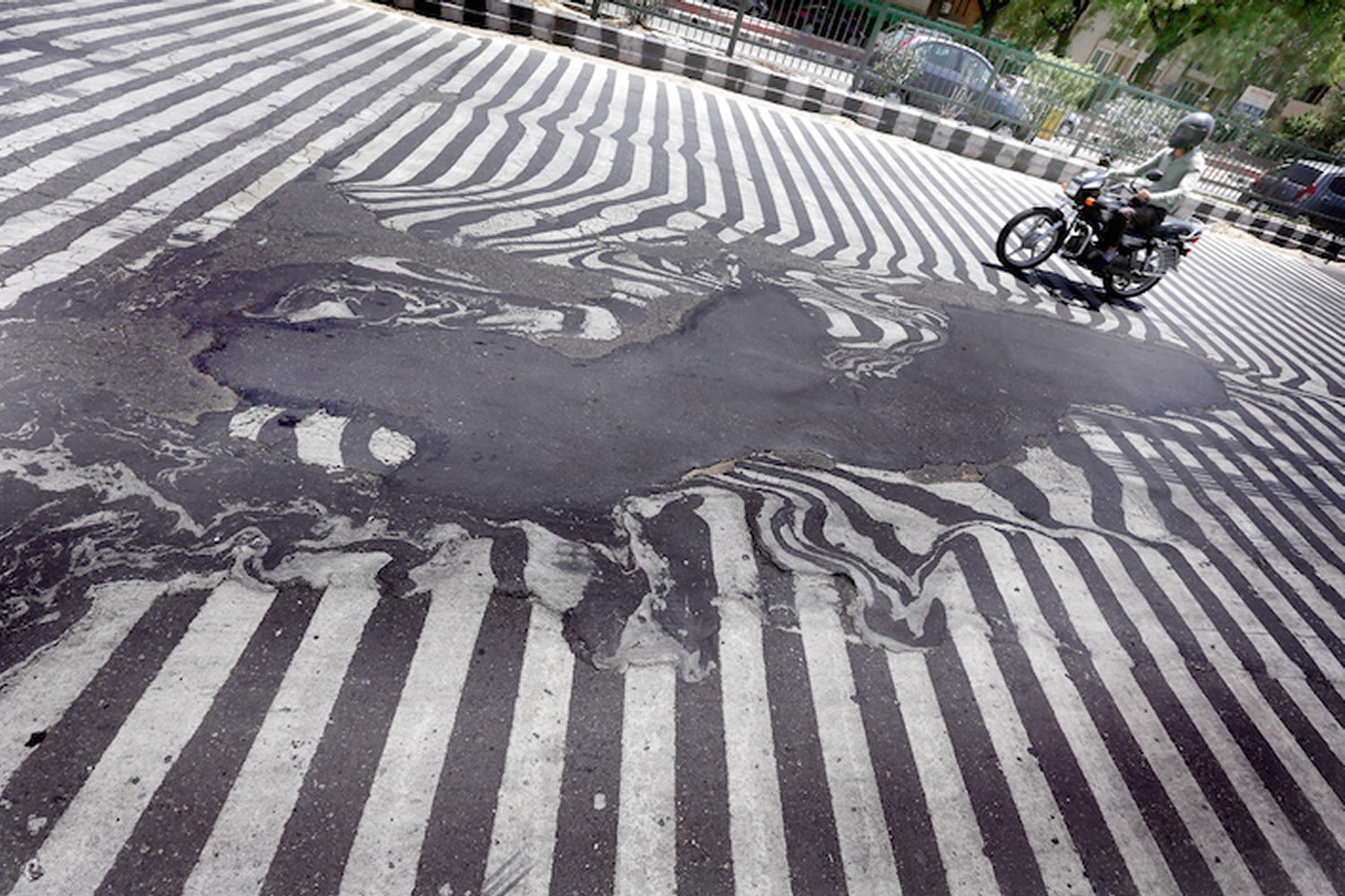
A weak ridge aloft has allowed extreme heat to build into the region while tropical dewpoints over 25°C remain in place. With these temperatures and dewpoints combined, several locations in Eastern India, like Bhubneshwar, have seen humidex values above 55°C – signifying heat stroke is probable with any time spent outside. Not only that, but overnight lows stayed well above 30°C for several days in some regions, providing no relief to the residents. Additionaly, dust storms have been taking place across the drought stricken areas in the north. In Rajasthan, a dust storm killed seven people two weeks ago. Heat waves can be crushing to developing countries, such as India, resulting in exponentially more deaths and damages compared to first world countries as residents have limited access to clean drinking water to hydrate themselves, never mind air conditioned houses.

Asphalt was literally melting away on New Delhi roads  due to high temperatures this week. (Source: Rappler)
Asphalt was literally melting away on New Delhi roads due to high temperatures this week. (Source: Rappler)

Over half of the deaths (1,334 deaths) associated with the heatwave came from the Andhra Pradesh province, while the most recent overall death tally reached 1,826 people. This, according to Jeff Masters of Weather Underground,  is the fifth deadliest heat wave in world history since record keeping began and second deadliest to India (deadliest was 1998). Water shortages were the main problem leading to dehydration and heat stroke; to combat this, the country brought in water tankers and aid to over 4,000 towns in the hardest hit areas.

Help might be on the way however. The seasonal rains that India experiences, called monsoonal rains, are advancing northwestward towards the heat-stricken provinces. These will not only bring much needed moisture to the region, but also allow temperatures to drop well below what India has been experiencing past few weeks. The few weeks preceding the monsoonal season typically do bring heat waves and dry weather to India, but some years are harsher and last longer than others.

Elsewhere in Weather News: October 11th, 2014

Two Dangerous Storms Spin Up

Notable activity has expanded from the tropical waters of the Western Pacific into the Bay of Bengal over the past week. We mentioned in last week’s EIWN that typhoon Vongfong could be a threat to Japan sometime this week – this has since become a reality. Formerly known as super typhoon Vongfong, typhoon Vongfong took aim at the Japanese island of Okinawa early this morning. Packing sustained winds of 140km/h which gusted to over 200km/h, the storm caused power outages to 27,000 residents and some locations on the island reported over 200mm of rain.

News agencies in the region report 20 injuries as of Saturday morning but thankfully no deaths from the storm. Vongfong is expected to curve northeast and slowly transition to an extratropical storm, but not before it brings significant rainfall to Japan’s main islands. This could be bad news, especially for the mountainous regions, as this is the second storm to hit Japan in the span of a week. With already saturated ground, these regions are more prone to landslides.

Cyclone Hudhud Develops

The second tropical storm is cyclone Hudhud which spun up only a few days ago. With sea surface temperatures approaching the 30°C mark in the Bay of Bengal, Hudhud quickly became a “very severe cyclonic storm” as classified by India’s Meteorological Department. As of Saturday morning Hudhud was 200 kilometres offshore of India with sustained winds of 205km/h.

Visakhapatnam radar image of cyclone Hudhud Saturday morning. Outer bands are already affecting India's coast and the eye is visible offshore. (Source: India Met Department)
Visakhapatnam radar image of cyclone Hudhud Saturday morning. Outer bands are already affecting India’s coast and the eye is visible offshore. (Source: India Met Department)

The evacuation of 150,000 people was underway along the coast because a significant storm surge of up to 1.8 metres is expected along the coast. Hudhud is forecast to make landfall overnight tonight just southwest of Visakhapatnam and continue inland, where it will die off, but not before dumping significant amounts of rain. The hardest hit areas can expect over 250mm of rain.

Elsewhere in Weather News: September 13th, 2014

Severe Flooding in Northern India and Pakistan

Flooding has been the story for both last weekend and this week as heavy monsoonal rains fell across northern India and Pakistan, having its strongest impact in the Kashmir, Jammu provinces and Jhang district. In this case, the heavy monsoonal rains were caused by very moist air advecting in from the Bay of Bengal due to a low pressure system located in northern India. This moist air was then lifted as it interacted with the rugged terrain of northern India and fell as heavy rain. Satellite estimates show that over 350mm fell in the hardest hit areas in a 7 day period, resulting in rivers overflowing their banks and putting residents at risk.

Satellite image of the low pressure system over northern India; combined with orographic lift, it made for heavy rain in the region. Taken on September 5th. (Source: NASA via Wunderground)

According to news outlets, 5,000 rescues had to be executed in the flooded region as people scrambled to higher ground. When floodwaters will have receded damages will be significant; about 980 villages in the region have seen flooding problems. On Friday night it was reported that 461 people have died due to the flooding with 600 more injured. Some 60,000 residents continue to evacuate to higher ground, not only in concern of flooding waters but also infrastructure being washed out leading to significant transportation problems for food and clean water. In developing countries the residents are typically affected by not only the initial disaster, but also the aftermath of the disaster. This is the case here as water borne diseases are of great concern to officials and will be a true threat to some residents as floodwaters recede. It’s estimated that over one million people have already been affected by this disaster.

In other news several tropical disturbances have formed in the Atlantic, including a tropical storm in the mid-Atlantic. These should be watched in the next few days, however, there is fairly strong shear in the region currently which is causing problems for these storms to develop further.

Elsewhere in Weather News: November 30th, 2013

Cyclone Lehar Hits India

This past week a weak cyclone hit India’s east coast as a weak cyclone depression. The cyclone – Cyclone Lehar was classified as a severe cyclone in the Bay of Bengal with winds over 100km/h but has since been downgraded. Unfavorable sea surface temperatures and shear for storm development did a good job on tearing up the storm apart before landfall. The storm made landfall as a tropical depression on Thursday, with winds of 60-70km/h at landfall. Evacuation precautions were taken by the India Meteorological Department because of the strength of the cyclone while it was over the Bay of Bengal but the only real threat that Lehar brought was flood threat. No significant damage was reported from the storm but some crops have been damaged and a few districts vulnerable to flooding in India’s Andhra Pradesh state have been affected by flooding.


Cyclone Lehar as it was struggling to organize over the Bay of Bengal. (Source: NDTV)

Arctic air dominated over a good part of both Europe and the United States this week which brought minimal significant weather to the regions. Apart from significant snowfall associated with a trough of low pressure affecting the eastern seaboard of the United States earlier this week, active weather has been kept to a minimum. The next big weather event is likely to be a winter storm which will affect the northern states (MT, ND) and even southern Manitoba on Tuesday and Wednesday of next week.