Variable Cloudiness, Light Snow Ahead For the Weekend

Southern Manitoba will see variable cloudiness over the next 3 days alongside some light snow on Saturday.

Winnipeg will see mixed skies today as cloud cover moves in ahead of a low pressure moving across Saskatchewan. Temperatures will reach a high near -4°C with winds increasing out of the southeast to 15-20 km/h. As the low moves into the province overnight skies will cloud over with non-accumulating light snow1 spreading across the region. Temperatures will dip to a low near -9°C.

Saturday will bring more light snow to Winnipeg for much of the day as winds become calm and temperatures climb to a high near 0°C. The snow will taper off as the cloud cover begins to break up Saturday night. By the time all is said and done a couple cm of snow may have fallen, but generally speaking, amounts look fairly light. The overnight low is forecast to dip to about -8°C.

Temperatures will climb towards the freezing mark in the Red River Valley on Saturday

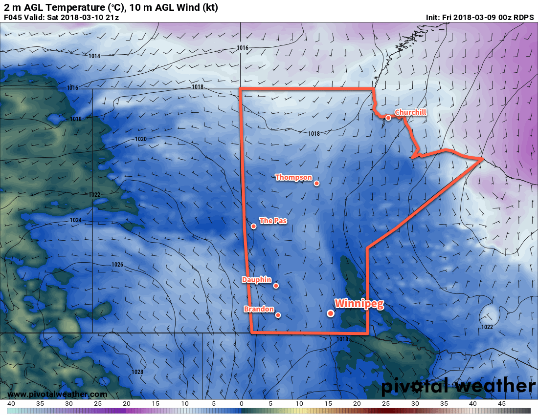
Winnipeg will see the sun poke out again on Sunday as the cloud cover from Saturday’s system slowly mixes out. Temperatures should reach a high near -1°C, but a ridge of high pressure moving in behind Saturday’s low will bring cooler overnight lows back to the region. Winnipeg will likely see a low near -12 to -15°C on Sunday night under clear skies.

Long Range Outlook

Next week is looking pretty quiet with variable cloudiness and near-seasonal temperatures. No news is good news, right?

Winnipeg’s seasonal daytime high is currently -3°C while the seasonal overnight low is -13°C.

  1. The snowfall will leave a dusting, not amounting to anything particularly notable or measurable.

More Mild Weather

Another spell of above-normal temperatures are on the way to the Red River Valley this weekend with daytime highs possibly reaching above freezing by the beginning of next week. Closer to Christmas, temperatures will return to seasonal values before cooler air slumps southward for the end of December.

Friday
-6°C / -9°C
Cloudy with periods of light snow
Saturday
-4°C / -7°C
Cloudy
Sunday
-2°C / -4°C
Mixed skies with a chance of flurries

Today marks the beginning of the warmup as cloud ahead of an approaching warm front blankets the province almost entirely. Here in the Red River Valley, light snow will likely be fairly widespread thanks to favourable temperature profiles throughout the lower levels of the atmosphere. As is typical in these situations, don’t expect any real accumulation. Temperatures will climb to an above-seasonal –6°C or so with light winds. Temperatures dip down to around –9°C tonight with mainly cloudy skies.

Saturday will be another cloudy day with temperatures climbing to around –4°C under mainly cloudy skies. The main difference will be that light snow won’t be nearly as likely, although a few isolated flurries are possible. Winds remain light and temperatures dip to around –7°C on Saturday night under cloudy skies.

Sunday will start…you guessed it, mainly cloudy once again with temperatures beginning to edge even warmer; the daytime high on Sunday will likely be around –2°C. The cloud may begin to scatter out in the afternoon providing a brief reprieve from the cloudy skies.

Some flurries are once again possible, however any real threat for snow will hold off until the overnight hours where a low pressure system passing to our south will potentially bring a band of snow across the Red River Valley with a couple of cm accumulation.

Snowy(-ish) Return to Winter

Looking ahead to next week, the weather pattern will be dominated by a large low pressure system developing over the eastern half of the United States & Canada. The Red River Valley will be positioned on the back-side of the strengthening low, locking us into northerly winds that will begin pulling Arctic air southwards through the Prairies.

The GFS 850mb temperature forecast valid on Christmas eve shows a trough of cold air plunging southeastwards behind a strongly tilted, major storm system centered over Ontario.

With the cooler air plunging southwards, daytime highs will cool off to the mid-minus teens for the second half of the week. Snowfall is a little uncertain at this point for us, but it doesn’t look like much will be seen here, making for a cool and blustery, but not particularly stormy, Christmas. It is worth noting that this storm system will have dramatic impacts on the eastern half of the country, including Toronto & Montreal, so if you have travel plans for the holidays that involve flying in that direction, be prepared for potential delays.

Clipper System Brings Brief Warm-Up

Temperatures are forecast to rise above 0°C by Saturday evening.

A low pressure system moving through the region on Saturday will bring a chance of snow and only slightly below normal temperatures to Winnipeg, however another Arctic ridge will plunge southwards behind the system returning us into the icy grip of winter as temperatures fall 10 to 15°C below normal. This is starting to look very similar to last year: the winter that wouldn’t quit, until suddenly it did. This December to March period will go down as one of the top 15 coldest on record, and not a single one of those top 15 coldest winters was followed by a notably above-normal April[1]. This means while milder weather is on tap, we’ll likely only be looking at returning to near-seasonal averages, especially while we still have such a significant snow pack on the ground.

Today will see temperatures climb to around -5°C by the late afternoon despite our fairly cold start this morning. Such large swings in temperature now are possible because our cold air is in a thin layer right near the surface[2] and the increasingly strong March sun is more able to effectively warm up all of the cold air. Winds will be light as we sit right underneath a ridge of high pressure.

Friday
-5°C / -13°C
Sunny.

Saturday
+1°C / -3°C
Mostly cloudy. Chance of light snow.

Sunday
⇓ -6°C / -20°C
Chance of flurries in the morning, then clearing & windy.

Saturday will be the warmest day we see for a while but unfortunately the weather won’t be all that pleasant to be outside. The temperature will start off around -13°C or so first thing in the morning and begin to climb as the approaching low pressure system pushes warmer air over the province ahead if it. The low pressure system will be running into a fairly stubborn ridge, however, and by mid-morning winds will begin to pick up and climb to 30-40km/h by the early afternoon with gusts to nearly 60km/h. A warm front should lift northeastwards through the Red River Valley through the afternoon, and temperatures behind the front will climb just over the freezing mark to around +1°C.

There will likely be some light snow produced ahead of the warm front as it lifts northeastwards, however right now it looks fairly weak and disorganized with no significant amounts expected. Skies will remain mixed-to-mostly-cloudy Saturday night as the temperature drops to around -2°C. The stronger winds will taper off behind the warm front and light winds are expected throughout the night.

Sunday will start off cloudy with a slight chance of flurries as the cold front associated with the system pushes through the region. Behind the cold front skies will clear and gusty northerly winds to 30-40km/h will pick up. The breezy winds will usher colder air into the province and temperatures will fall to around -5 or -6°C by Sunday evening. Temperatures will drop to around -20°C, or perhaps a bit colder, under clear skies on Sunday night.

That hope on the horizon? Still there!

On Wednesday we mentioned that there was some hope on the horizon for warmer weather, and it’s still there! The latest NAEFS 8-14 day temperature anomaly forecast is showing a general push towards seasonal temperatures across much of the Prairies as April gets going. Temperatures are forecast to climb into the low single-digits by the middle of next week, and the general “near normal” trend of the NAEFS hints that we may actually be heading into a more prolonged period of seasonal weather with daytime highs above 0°C.

The NAEFS 8-14 day outlook is showing near-normal temperatures for Southern Manitoba.

Anything to melt the snow will be a welcome site to winter-weary Winnipeggers. As pointed out over by JJ over at his Winnipeg Weather blog, this December to March period will be the coldest one in 115 years with the next coldest being the winter of 1898-99. With last night’s low dropping below -20°C, Rob pointed out over at Rob’s Obs that it will mark the 15th time this month temperatures have dropped below -20°C; typically that only happens 5 times in March.[3]


  1. The 1872 to 2013 mean temperature – an average of both the highs and the lows – is 3.5°C.  ↩
  2. Instead of a very deep layer, like we would see in January or February.  ↩
  3. Apparently I’ve dropped the ball by waiting until March was <em>over</em> before calculating my March statistics!  ↩

More Cold

This week will see below-normal temperatures continue, though it won’t be quite as cold as the weather this past weekend.

Cold weather will continue in southern Manitoba on Monday

Cold weather will continue in southern Manitoba on Monday

Monday

Monday
-18°C / -27°C
Increasing Cloudiness

Today is off to a cold start, but temperatures will increase a fair bit through the day. This afternoon should see highs reaching into the minus teens, a nice recovery from this morning’s low. The wind looks to remain light, making daytime conditions reasonable.

Tuesday

Tuesday
-15°C / -23°C
Mainly Sunny

Tuesday will see daytime temperatures improve a bit over Monday’s values. Highs will be in the mid minus teens with light winds, making for a generally pleasant day.

Wednesday

Wednesday
-11°C / -24°C
Light Snow

The warming trend will continue on Wednesday as a passing low pressure system ushers in a strong southerly flow. Unfortunately, the warmer temperatures brought in by this strong south wind will be largely offset by the cold wind chill values they will generate. We may also see a bit of snow on Wednesday in association with that weather system, making the day a mixed bag overall.

Long Range

The long range forecast continues to look bleak. There have been some hints of a warm up in about 7-10 days, but there is still too much uncertainly to get excited about that.