Elsewhere in Weather News: December 20th, 2014

Snow Squalls Paralyze Several Japanese Prefectures

This week’s Elsewhere in Weather News focuses on western side of the Japanese islands of Hokkaido and Honshu which have seen significant amounts of snow from a snowstorm that hit midweek.

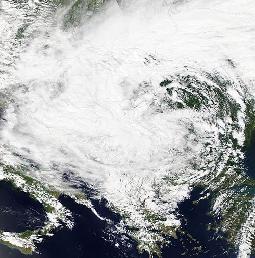
An area of low pressure which was moving northeast along Japan’s west coast quickly deepened to a 949mb low and whipped Japanese islands with winds of 60 to 100km/h. These winds, combined with widespread amounts of 20-30mm of rain ahead of the system. By the time the low reached the northern islands of Japan, strong northwesterlies kicked in over Japan’s main island of Honshu. Cold Siberian air infiltrated in over the Sea of Japan behind the low which stalled out, creating prime conditions that would sustain the development of snow squalls for a long period of time.

IR Satellite image of the mature low pressure system over northern Japan with circled area showing snow squalls forming over the Sea of Japan.

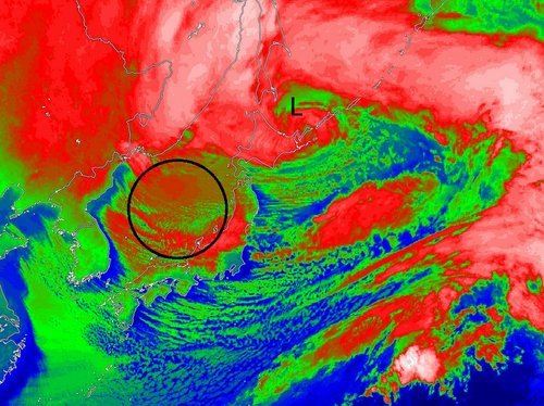
Snow squalls occur when cold air moves over a warm body of water, creating an unstable temperature profile. With the instability in place, snow squalls were able to from over the Sea of Japan and make their way to the western side of Honshu. Orography – the effect that terrain has in creating localized impacts on the weather – also played a role in providing additional lift which resulted in higher accumulations. The storm prompted blizzard warnings to be issued across 11 prefectures in western Honshu and Hokkaido.

These are the areas that saw the highest snowfall amounts recorded – accumulations generally ranged from 50cm to 120cm, but locally higher amounts were recorded near Niigata, Japan, up to 200cm. The storm caused 19 fatalities and forced cancellations of 600 flights across Japan.

Mountainous terrain located to the southeast of Niigata enhanced the snowfall amounts in the region.
Last week, another storm of similar strength brought significant snow to parts of Honshu as well as the northern island of Hokkaido. The forecast looks to favour more snow squalls as a similar setup to what was seen this past week – a strong low will be located near the northern island of Hokkaido and will draw in more cold Siberian air over the Sea of Japan.

Above-Normal Temperatures to Start the Week

More above-normal weather is in store to start the week – what’s not to like!

Temperatures on Monday will be near normal in Southern Manitoba

Monday

Monday
11°C / 3°C
Mainly Sunny

Today will see near normal temperatures in southern Manitoba. Highs will be around or just above 10C with mainly sunny skies. Winds will be light, making for pleasant conditions overall.

Tuesday

Tuesday
17°C / 8°C
Mainly Sunny

Tuesday will see above-normal conditions return to southern Manitoba. Temperatures will be in the mid to upper teens with skies remaining mainly sunny. A strong south-east wind will be in place throughout the day, putting a bit of an edge on what would otherwise be a very nice day.

Wednesday

Wednesday
16°C / 8°C
Mainly cloudy with chance of showers

Warm weather will continue on Wednesday, with temperatures remaining in the mid teens. A weak low pressure system is expected to pass through southern Manitoba during the day, possibly producing some showers in its vicinity. This system will also likely bring in some heavier cloud cover, so Wednesday probably won’t be as sunny as Monday and Tuesday.

Long Range

Long range modelling suggests that above-normal weather [1] will continue through the end of October. That doesn’t mean that every single day will be warmer than normal, but the majority should be. Enjoy the pleasant end to October!


  1. Normal highs for the last stretch of October sit around 9°C.  ↩

Elsewhere in Weather News: May 24th, 2014

Balkan Flooding Could be Billion Dollar Disaster

This past week the full effects of the Balkan floods have been coming to head as floodwaters retreat. The Balkans are located in Southeast Europe just to the east of Italy across the Adriatic sea. The flooding event which started on May 14th and lasted up until Saturday May 17th, caused the most severe flooding to Serbia and Bosnia. The flooding was caused by a deep low pressure system which moved from the Adriatic Sea and stalled for a few days over the Balkan Peninsula. The low was not only able to tap into a great amount of moisture but also use the mountainous terrain to its advantage. By forcing air up the mountain, the air then cools, condenses and subsequently falls as precipitation; this is also called orographic lift.

Low spinning just northwest of the Balkan Peninsula bringing heavy rain to the region. (Source: NASA)

Several towns from both countries were severely hit from this event including Belgrade, the capital of Serbia, where a whopping 205mm of rain fell and broke the previous record (175mm) from 1897. Across both countries, over 2,100 landslides were reported and the Bosna River also overflowed its banks inundating numerous large cities (Doboj, Maglaj). Unfortunately 55 people died in the event as well as large amounts of livestock. In total over one million people in the region have been affected. The magnitude of the damage to the infrastructure is significant – 3,000km of roads have been damaged or washed out as well as about a third of all railroad lines. This is likely to be counted as a billion dollar disaster.

Search and rescue efforts have eased in the region this past week and the next phase will be the cleanup. Weather looks to be variable in the coming days as popup showers and thundershowers are possible in the afternoon hours.

Wet End to a Wet Long Weekend

This long weekend will end on a rainy note – big surprise! Conditions should gradually improve as we move into the work week.

image

A significant weather system will spin just to our south for the next couple days

Monday and Tuesday

Monday
image
Periods of Rain
11°C / 7°C
Tuesday
image
Periods of Rain Ending
14°C / 5°C

A powerful weather system over the Dakotas/Minnesota region will continue to bring rain to Southern Manitoba on Monday. Weather models wrap a band of rain through much of Southern Manitoba through all of Monday and even into Tuesday. Models are struggling to resolve the intensity of this rain and therefore total accumulations are a major question mark. If this band does indeed stall through Southern Manitoba for the next day and a half as models indicate, then storm total accumulations could well be in the 50 to 100mm range that models are predicting. On the other hand if things pan out differently than the models predict, which looks probable, then we’re probably looking at more like 30 to 60mm on a widespread basis (these numbers include Sunday accumulations as well by the way). I believe there is a sufficient moisture feed for those high end amounts (close to 100mm) on a localized basis. However, the intensity of rain appears to be lower than model predictions, so I think in general storm totals will be closer to the 30-60mm range mentioned above. Either way a lot of rain will be had today and tomorrow, not the way most people had hoped to spend their Victoria Day.

Wednesday

Wednesday
image
Mainly Sunny.
20°C / 5°C

Conditions should improve for Wednesday as we experience a brisk north-easterly flow behind Monday’s system. Temperatures should be in the upper teens or lower twenties.

Long Range

The late week outlook looks fairly seasonal temperature wise, with little or no additional precipitation. Long range guidance doesn’t give a clear picture of how the rest of May will play out. It doesn’t appear that we’re headed for any kind of significant cool down, but a large warm up doesn’t look likely…hopefully the long range forecast will show more clarity later this week.