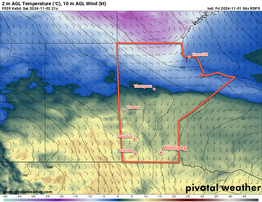
Mild early-November weather will continue into the weekend, but a disturbance moving into the region will bring rain later on Sunday to end the weekend.
A persistent southerly flow will bring warm temperatures to southern Manitoba over the next few days.
With southerly winds up to around 20 km/h, daytime highs will climb into the 5 to 10 °C range in Winnipeg right through the weekend.
Today will bring mainly cloudy skies to the region, but no precipitation is expected. Skies will clear this evening with winds becoming light. Under clear skies, temperatures will dip down to around -5 °C overnight.
Saturday will bring sunnier conditions; mixed skies in the morning will give way to clear skies in the afternoon. Southerly winds will pick back up to around 20 km/h in the afternoon.
Thicker cloud cover will begin to work into the region overnight ahead of a broad disturbance that begins to track across the Prairies. This cloud will keep it warmer overnight with lows only around 0 °C.
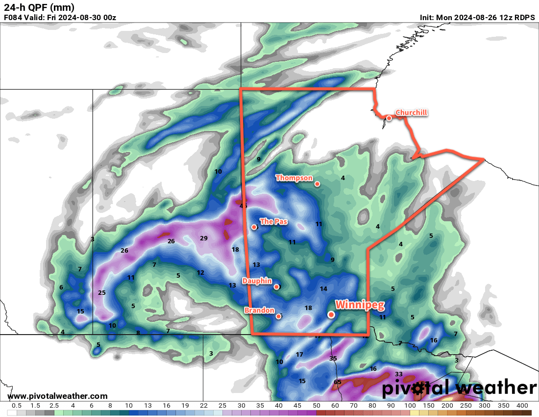
On Sunday, the first notable weather in quite a while will move through the province. A broad area of low pressure will track through the province, bringing a chance of rain showers to most of the region. Heading into Sunday night, a more organized area of rain will develop over North Dakota and lift northeast, bringing steadier rain to the Red River Valley and areas east. Many areas will likely see 5 to 10 mm of rain by Monday morning.
This system will keep it very mild on Sunday night with lows only around 5 °C. The rain will taper off later Sunday night.
Long Range Outlook
Despite the passage of Sunday’s system, the weather will stay seasonably mild to start next week as another low begins to track east across the southern Prairies. It will bring even milder weather to Winnipeg on Tuesday, but then it will sweep a cold front across the region that will bring a chance of rain or snow to the region.
Temperatures will be cooler in the wake of this system, but again, it looks to be short-lived as mild weather could return for next weekend.
Today’s seasonal daytime high in Winnipeg is +3 °C while the seasonal overnight low is -6 °C.
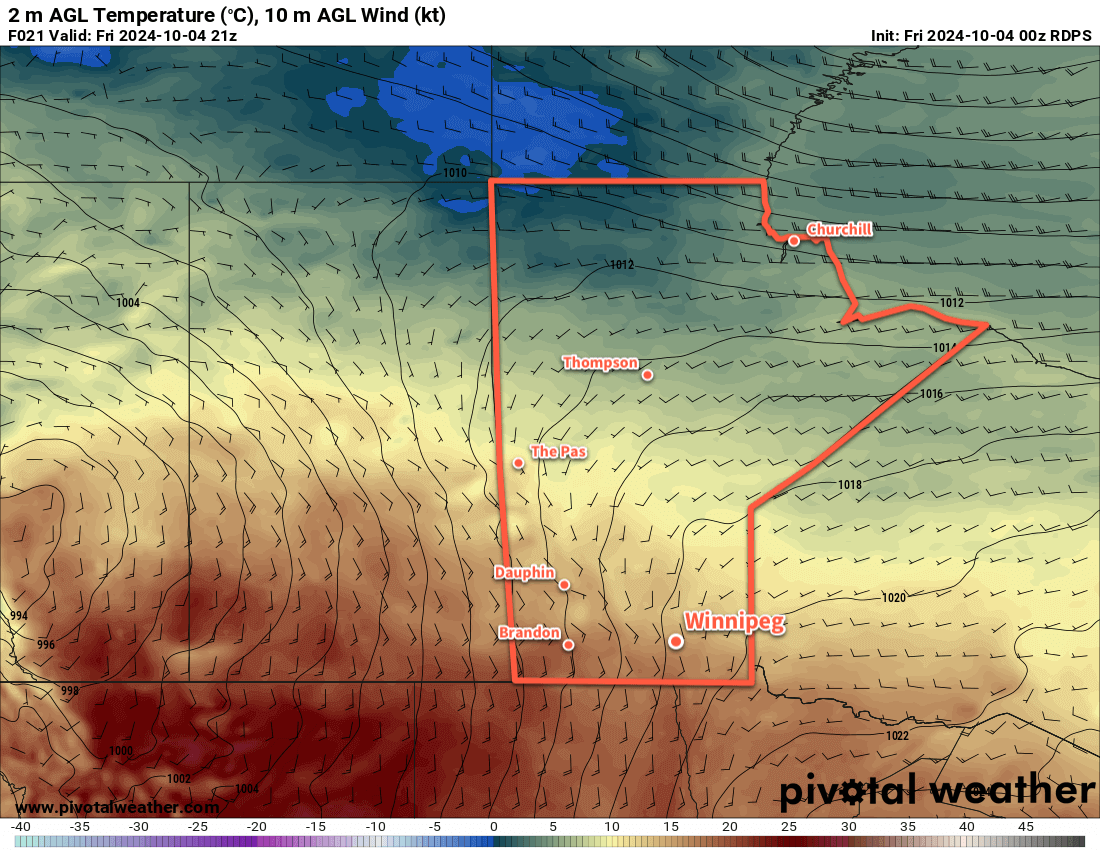
After a cold start to Friday morning, temperatures in southern Manitoba will jump back to seasonably warm values, though the weekend will end with blustery conditions and cooler temperatures after rain showers move through on Saturday.
Despite a cold start to the day, a low pressure system over the western Prairies will push warmer temperatures back into southern Manitoba today.
Despite a frosty start to the day for many places in southern Manitoba, temperatures will quickly bounce back to above-seasonal values today. A low pressure system developing over the western Prairies will begin spreading warmer air eastwards into Manitoba. Southerly winds will pick up into the 30 gusting 50 km/h range today with sunny skies and an afternoon high in the upper teens. Those winds will continue right through the night as the low tracks through Saskatchewan, keeping temperatures mild with lows in the low teens.
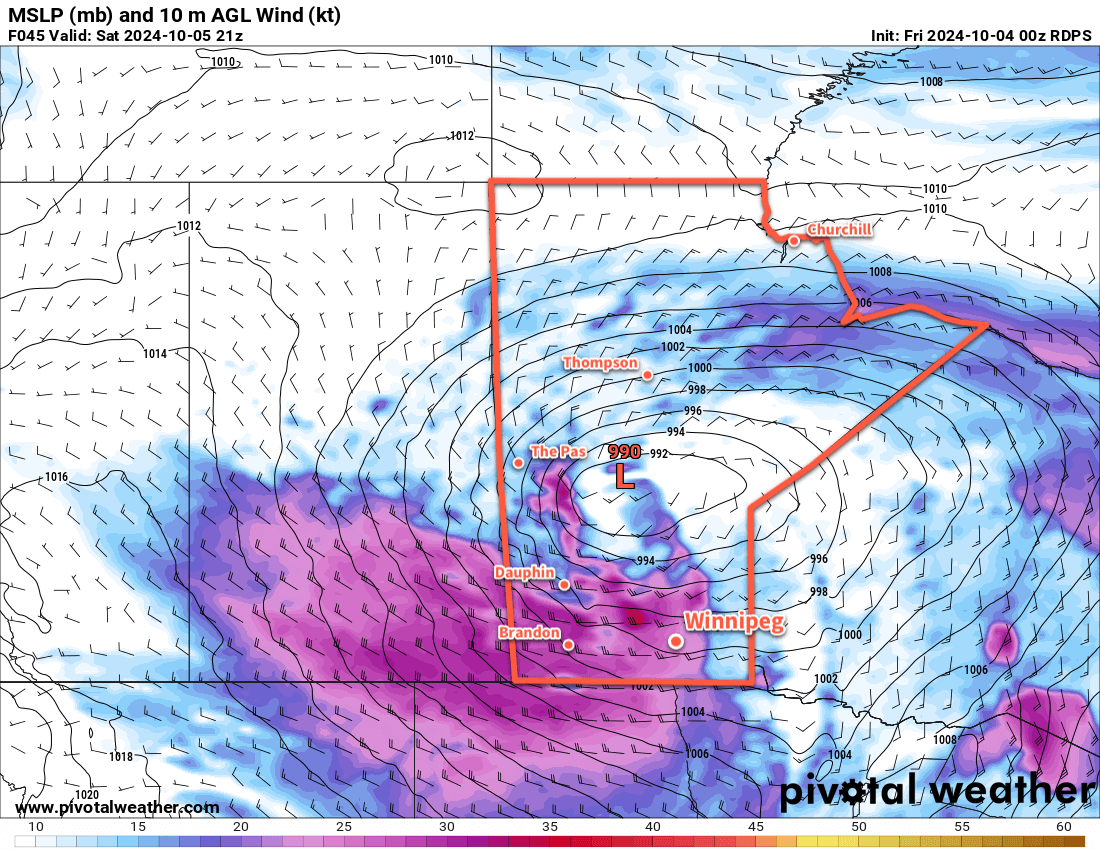
Despite being relatively warm, Saturday will be a bit of an unpleasant day. The main driver for the weather will be a low pressure system crossing through the Interlake, with an energetic cold front that sweeps through later in the day. The day will start with increasing cloudiness as moderate southerly winds continue across the region. Temperatures will climb back into the upper teens as rain spreads into western Manitoba. There’s a small chance of some midday showers in Winnipeg, but the better chance for rain will develop later in the afternoon as a cold front sweeps through. Winds will shift from southerly to westerly and strengthen to 50 gusting 70 km/h as rain wraps into the region.
Strong westerly winds will blast through southern Manitoba on Saturday afternoon behind a cold front that sweeps through the region.
The rain will taper off overnight as temperatures head to a low in the mid-single digits. The winds will continue through the night, shifting to the northwest and gradually easing into the 30–40 km/h range by Sunday morning. By the end of the night, the main area of rain will be well to the east of the Red River Valley, but a couple bands of lake-effect showers may linger in the lee of the lakes into Sunday morning.
Sunday will be a cooler day with northwest winds of 30 gusting 50 km/h and a high in the low teens. Skies should clear for the afternoon bringing sunshine back to the region. Temperatures will dip close to freezing on Sunday night with clear skies and easing winds.
Long Range Outlook
Next week will bring warmer conditions back to southern Manitoba as the upper low over western Hudson Bay retreats northwards and upper ridging is able to redevelop over the Prairies. Much of the week will bring daytime highs in the upper teens or low 20s with overnight lows near the 10 °C mark. The week should also be dry with no significant precipitation in the forecast.
Today’s seasonal daytime high in Winnipeg is 14 °C while the seasonal overnight low is +2 °C.
In a stark contrast to the past weekend, a ridge of high pressure will keep temperatures seasonably cool much of this week. A passing low pressure system will bring milder temperatures on Wednesday followed by a chance of rain on Thursday.
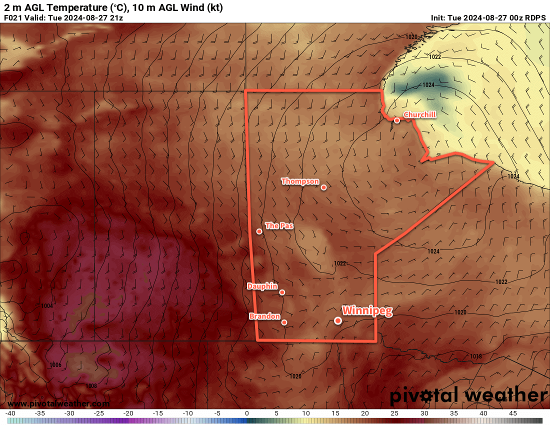
Seasonably cool temperatures will sit over southern Manitoba today while warmer weather builds back into the western Prairies.
An Arctic high trundling east across northern Manitoba will keep temperatures cool and the humidity dry today. A disturbance rolling across North Dakota towards Lake of the Woods will bring cloudy skies into the region later this morning. Combined with a light northeast wind, daytime highs will be cool at around 20 °C in the Red River Valley.
Skies will clear this evening as the disturbance heads off into Ontario. The Arctic high will trundle towards James Bay, shifting the light winds in the Red River Valley southerly. Temperatures will dip down to a low near 10 °C.
On Wednesday, the next weather system to impact the region will begin taking shape. A vigorous upper-level disturbance will move from the British Columbia interior into today to southern Alberta by Wednesday. As this tracks east, it will pump much warmer air back into Saskatchewan as a low pressure system develops over the central Prairies. By Wednesday morning, a low will sit over central Saskatchewan with a warm front that drops southeast across southern Manitoba and a cold front southwards towards the Montana/North Dakota border.
This system will bring southerly winds to Winnipeg on Wednesday up to around 30 gusting 50 km/h. Temperatures will be warmer with highs in the mid-20s under mainly sunny skies. In the evening, a low-level jet — a corridor of fast-moving air about 1.5 to 3 km above the ground —will develop with wind speeds around 60 km/h (30–35 knots). These will help develop and sustain a band of showers and thunderstorms through the night that extend from North Dakota northwest to central Saskatchewan. For areas in southern Manitoba, there will be a low risk of a severe thunderstorm on Wednesday night with large hail and wind gusts the main hazards.
One model’s forecast for daily rain accumulations on Thursday; while likely too widespread, it shows that showers are possible across much of southern Manitoba on Thursday.
Temperatures will dip to a low in the mid- to upper-teens on Wednesday night with moderate southeast winds continuing.
The band of [thunder]showers will reach Winnipeg either late overnight or early Thursday morning, then sunny breaks will develop after they pass as winds shift westerly. Temperatures will climb back up to the low 20s with mixed skies and a chance of more showers in the afternoon.
Temperatures will head to a low in the mid-teens on Thursday night with partly cloudy skies and west-northwest winds of 20 to 30 km/h.
Long Range Outlook
Settled conditions will redevelop for the end of the week and into the weekend as the mid-week disturbance heads off. A ridge of high pressure will build in from the west and bring settling conditions and sunnier skies.
Daytime highs should sit in the 20 to 25 °C range through the weekend with overnight lows slumping from the mid-teens to around 10 °C.
It’s a pretty pleasant forecast, and will be a nice recovery from the intense heat and humidity the region experienced over the weekend. I hope families with kids can get out there and enjoy the final days of summer before school kicks off again!
Today’s seasonal daytime high in Winnipeg is 24 °C while the seasonal overnight low is 10 °C.
An energetic and dynamic weather system lifting through the Prairies will bring hot and humid weather to Winnipeg this weekend. As it passes through on Sunday, severe thunderstorms will be possible across the region.
Hot and humid weather will build into the southeastern Prairies this weekend.
Now that the morning fog and stratus has burnt away, it will get cooking over the Red River Valley. Temperatures will climb close to 30 °C with dew points close to 20 °C making it feel like the upper 30s through the afternoon.
Heading into the night, a low pressure centre will develop over southern Alberta and begin moving northeast. As it forms, it will begin to lift a warm front northwards out of the United States. This will bring partly cloudy conditions to the region overnight with strengthening southerly winds. Winds in Winnipeg will likely reach around 20 km/h by early Saturday morning, then quickly strengthen into the 30 to 40 km/h range as it warms up.
Saturday will bring mixed skies to Winnipeg with a high in the low 30s. Dew point values should sit in the high teens, though an axis of ≥ 20 °C dew points is forecast to lie immediately west of the Red River Valley. This again will result in humidex values in the upper 30s through much of Saturday.
It will be a hot, muggy night on Saturday night with overnight lows dipping only into the low 20s. The breezy southerly winds should continue through the night under partly cloudy skies.
Severe Thunderstorm Threat Develops on Sunday
The system moving through the Prairies, in addition to the heat and humidity here, will bring multiple rounds of potentially severe thunderstorms to the broader region. Severe thunderstorms are possible this afternoon over southwestern Saskatchewan; these storms will blossom into an area of showers and thunderstorms that track northeast across southern Saskatchewan overnight. On Saturday, another round of severe thunderstorms are possible beginning near the Manitoba/Saskatchewan border in the afternoon and spreading northeast across the Interlake through the night. Much of this activity is expected to stay north of the Trans-Canada Highway corridor in the Red River Valley, but isolated thunderstorms look possible in SW Manitoba.
By Sunday, though, it becomes the Red River Valley’s turn for thunderstorm activity. Sunday will likely be the warmest, muggiest day of the three with highs in the low 30s and dew points climbing into the low 20s, making it feel a lot closer to 40. The southerly winds will weaken in the afternoon as a warm-sector trough moves into the region.
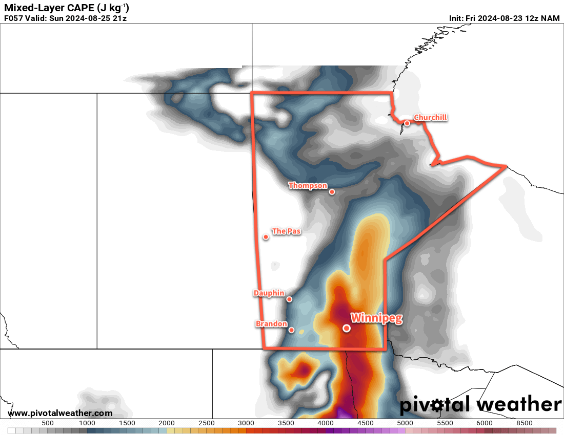
For the enthusiasts out there: both the dynamic and thermodynamic setup for Sunday points towards a potent thunderstorm risk. The heat and humidity will drive MLCAPE values to over 2,500 J/kg, while late the day the right entrance to a 50 knot jet streak at H500 slides over the region. Surface winds ahead of the warm-sector trough are solid at 15 knots out of the SSE, but winds become weak and disorganized between the trough and the cold front. Bulk shear values are roughly 30 to 35 knots. MLLCL values are forecast to be moderate, roughly around 3,000 feet. Lastly, PWAT values will climb above 45 mm with Bunker storm motion values around 15 to 20 knots out of southwest.
An axis of significant amounts of instability, capable of producing dangerous thunderstorms, will develop over the Red River Valley on Sunday.
The result of all that is that there is a potent thunderstorm risk that will develop on Sunday afternoon. Either the warm-sector trough or approaching cold front could be drivers for initiation, and both will be capable of producing dangerous thunderstorms capable of producing all modes of severe weather: very large and damaging hail, wind gusts of 90 to 120 km/h or higher, tornadoes, and torrential downpours capable of localized flash flooding.
All storms will have a roughly equal chance of producing damaging hail or wind gusts. There is a non-zero tornado threat across the region, though it will likely be maximized south of Winnipeg; a weak low centre is forecast to develop over northwestern North Dakota and weaken as it tracks northeast; if it holds together it could result in a stronger, more backed surface flow towards the southwestern Red River Valley that could enhance the tornado risk. Every thunderstorm will produce very heavy rainfall, but relatively high storm motions will likely limit the amount of rain a single storm gives to any one place. Widespread amounts of 20 to 50 mm are possible with the thunderstorm activity. If an area happens to have multiple thunderstorms pass over them, or a storm lingers for a longer period, then accumulations of 50 to 125 mm will be possible.
The thunderstorm activity will track east into the evening, pushed along by an advancing cold front moving through the region. Temperatures will head back down into the upper teens with a moderate northwest wind overnight.
Long Range Outlook
Next week will be an unsettled one for the region with seasonal temperatures. Monday should be pleasant, then cloud and showers will be possible on Tuesday as the region is clipped by a system moving through the Dakotas.
Showers and thunderstorms will again be possible on Wednesday evening through Thursday as another low pushes into the Prairies.
And that’s it for today! Stay safe in the heat, enjoy what you can, and make sure to check on anyone you know who’s more vulnerable (especially on Saturday night).