For the first time in a long time we’re in for an extend period of mild weather, sounds nice doesn’t it!
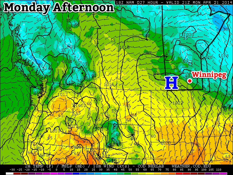
A surface high will bring pleasant conditions to southern Manitoba on Monday
Monday
Monday
9°C / -2°C
Mainly Sunny
Today will feature slightly below seasonal temperatures in southern Manitoba. Highs will range from the low teens in south-western areas, to upper single digits in the Winnipeg region. We’ll be under a surface ridge of high pressure, which should keep winds relatively light and skies relatively clear.
Tuesday
Tuesday
14°C / 4°C
Mainly Sunny
Tuesday looks to be another nice day in southern Manitoba. Temperatures should be near to slightly above-seasonal, meaning high temperatures in the low to mid teens. The wind will begin to increase late in the day, particularly over western Manitoba, as a developing weather system approaches the region.
Wednesday
Wednesday
9°C / 4°C
Mainly Cloudy. Chance of Rain.
Wednesday will see mild weather continue, with temperatures in the upper single digits, although we may get a bit wet. That developing weather system noted for Tuesday will spread rain, or even snow, into Manitoba on Wednesday. It’s too early to say where the main impacts of this storm will be, but it looks to become a fairly major storm for some part of Manitoba. Some of the current models take the storm up into Central Manitoba, while others take it through southern Manitoba. Areas to the north of its track could potentially see heavy snow, while areas to the south will see rain. As more certain information about this storm is available, we’ll be sure to let you know.
Long Range
The long range forecast suggests we’ll generally see normal to slightly-below normal weather to close out the month of April. That means high temperatures generally near the 10°C mark. While 10°C is nothing spectacular for this time of year, it certainly sounds ok given how awful the last several months have been.
This week will start out with mild weather in southern Manitoba while a major storm system passes just to our south.
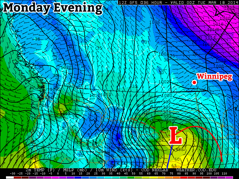
A major weather system will pass just to our south on Monday
Monday
Monday
-1°C / -4°C
Increasing Cloudiness. Chance of Flurries.
Today will feature nice weather in southern Manitoba. Temperatures will be near the zero degree mark with light winds. However, just to our south a major storm will be taking shape. This storm is expected to bring heavy snow to the Dakotas and Minnesota. There is still uncertainty about where the heaviest snow will fall, but if you have travel plans into the northern United States early this week you’ll definitely want to check the weather forecast along your route.
Tuesday
Tuesday
-1°C / -10C
Mainly Cloudy
Tuesday will be another mild day in southern Manitoba. Temperatures will once again be near the freezing mark with a light northerly flow. As you might expect, this north wind will be generated by that big storm to the south.
Wednesday
Wednesday
-1°C / -12°C
Mainly Sunny
Wednesday will be another mild day, with temperatures generally just below freezing. We should finally be clear of the storm system from earlier in the week, with clear skies being the order of the day. The wind will be from the north-west, but it won’t be particularly strong.
Long Range
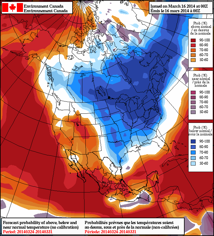
The long range forecast calls for below normal temperatures in southern Manitoba for the end of March
Unfortunately, the long range forecast suggests a return to more wintry conditions for awhile. Most long-range guidance shows cool to cold conditions for the end of March. It remains unclear how the month of April will unfold.
A textbook frontal passage is in store for the Red River Valley over the next few days as an incoming warm front brings a chance of flurries and another mild day before the cold front slumps through the region at week’s end, bringing another windy chance for snow.
Wednesday
-10°C / ⇑ -3°C
Cloudy, light flurries starting midday.
Thursday
+4°C / -7°C
Warm with mixed skies. Windy with flurries overnight.
Friday
-6°C / -20°C
Chance of early morning flurries, otherwise mainly sunny.
We’re off to a cold start this morning, but temperatures will soar today as a strong warm front pushes across the Red River Valley. Southerly winds will pick up through the day to around 30-40km/h by mid-afternoon. There will be a chance of flurries beginning midday and lasting through the early evening. No significant accumulations are expected and thanks the warming temperatures and recent melting, blowing snow should be minimal. Temperatures will climb to around -10°C by evening but continue rising through the overnight period to nearly -2°C by Thursday morning.
Mild air is set to push into Southern Manitoba again on Thursday.
Thursday will be another beautiful day very reminiscent of Monday this week. Winnipeg will see relatively light winds and mixed skies as the temperature climbs all the way to 4°C. Similar to Monday, there will probably be significant variation across the city with some places climbing several degrees higher to 7-8°C.
Things will take a less pleasant turn on Thursday night when a cold front slices through Southern Manitoba. Gusty winds out of the northwest to 40km/h will accompany some flurry activity that will spread into the Red River Valley from north to south through the mid-to-late evening hours. The wind and any straggling flurries should taper off early Friday morning.
Friday sees an Arctic ridge of high pressure building into Manitoba bringing cooler temperatures with it. In Winnipeg, temperatures will be some 10°C cooler than Thursday with a daytime high only near -7 or -6°C under mainly sunny skies.. Winds will remain light and the temperature will drop close to -20°C on Friday night.
Cool Weekend Ahead
Temperatures will remain well below normal through the weekend in the Red River Valley. Saturday’s high looks to be near -15°C under mainly sunny skies while Sunday sees the coldest axis of air shifting off to the east, allowing temperatures to climb to the low minus single digits with a few cloudy periods.
In the southwest corner of the province, flurries will be possible numerous times over the next 5 days as the main frontal zone sets up across the region and weak disturbances ripple along it.
Temperatures will slowly return to slightly below-seasonal values through the remainder of the week as unsettled weather pushes into the Red River Valley. While the main weather focus will remain further east as a significant low pressure system lifts through Central Ontario, the storm will have a broad reach spanning all the way from the Maritimes to Southern Manitoba.
This forecast precipitation panel from the GDPS shows the significant extent of this week’s develping storm.
One More Mild Day
Wednesday
-4°C / -9°C
Increasing cloud; mild. Snow overnight.
Today will bring another fairly nice day a westerly flow aloft continues spreading warm air into Southern Manitoba. Temperatures should climb up to around -4°C with relatively light southeasterly winds. Cloud coverage will increase through the day as a trough of low pressure works it’s way towards the Red River Valley, bringing with it another batch of snow and the beginning of of our transition back towards seasonal to slightly below-seasonal temperatures.
As the cloud pushes in, so too will the snow. Initially, the snow will spread into the Parkland region of the province – through Dauphin and down towards Minnedosa – before pushing eastwards into the Interlake. As the system tracks east, it will do it’s best to develop some light snow over the Red River Valley as a low-level jet ramps up and lifts over the warm front stationed in North Dakota. It’s still too early to say exactly how this is going to shape out: the location and intensity of the precipitation will have a lot to do with the exact track & timing of the system. If things line up right, we may see a band of moderate snow track across the RRV fairly early in the evening, but just as likely is that the LLJ doesn’t really get precipitation going until it’s further east into Minnesota, which could drastically reduce snowfall expectations depending on how much of that is able to wrap all the way around the low back into the Red River Valley.
Snowy Thursday
Thursday
⇒ -9°C / -15°C
Periods of light snow; 3-6cm accumulation.
Thursday looks to bring more snow Southern Manitoba as Wednesday’s system is absorbed into a much larger storm lifting northwards through Central Ontario. As a notable aside, this storm is absolutely massive, stretching from Manitoba all the way to the Maritimes and from Quebec all the way southwards to Florida.
The inherent uncertainty of both track and timing makes snowfall totals quite difficult. The highest confidence is for snow through the Parkland into the Southern Interlake and east. A combination of strong lift and a decent deformation zone look to produce a band of snow with totals from around 5-10cm. Assuming the currently forecast track of the system, we would then see around 3-6cm of snow through the northern Red River Valley – including Winnipeg – and 1-3cm or less through the southern Red River Valley.
Temperatures will be cooler on Thursday as a northwesterly wind keeps temperatures steady near -9°C. Temperatures will dip to around -15°C tomorrow night under mainly cloudy skies with a chance of a few flurries.
Cool Weekend Ahead
Friday
-13°C / -20°C
Mixed sky; chance of flurries.
Friday continues the cool trend with temperatures only recovering a degree or two – to around -13°C – while moderate northwesterly winds continue to make things unpleasant. There will be a slight chance of flurries through the day under mixed skies, but things should clear out on Friday night as we head to a low near -20°C.
The weekend will bring more cool temperatures as daytime highs slump towards -17 or 18°C under sunny skies by Sunday and overnight lows dropping below -20°C in the overnight periods.