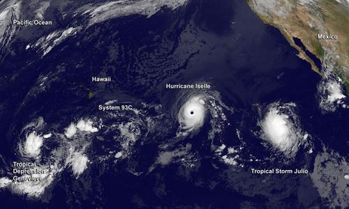
Multiple Hurricanes and Typhoons in the Pacific
The Pacific Ocean has been busy lately and continues to impress this past week with four different tropical cyclones simultaneously ongoing.

The first, typhoon Halong (formerly super typhoon, talked about in last week’s EIWN), is closing in on Japan’s main islands and is forecast to make landfall later this afternoon. Shikoku will be hardest hit; here Halong will make landfall with sustained winds of 120km/h – the equivalent of a category one hurricane.
The second is super typhoon Genevieve. This storm is unusual in such that it was formerly known as hurricane Genevieve – it has since crossed the International Dateline and is now classified as a typhoon. This is the first tropical cyclone to have done this since 2006. Thankfully Genevieve is in the middle of the Pacific and is not expected to make landfall any time soon.
Hurricane Julio is the third tropical cyclone in the Pacific. This one is forecast to pass just north of the Hawaiian Islands. The outer bands of the hurricane are still expected to affect the islands by bringing heavy rains to the now-saturated soils of Hawaii – soils saturated courtesy of the next storm: Iselle.
Tropical storm Iselle is the fourth and has had the biggest impact on American soils. The tropical storm made landfall on the Big Island of Hawaii yesterday and brought with it high end tropical storm force winds combined with copious amounts of rain (over 100mm). Interestingly enough, this is the first time a tropical storm has hit Hawaii since 1992 and the first time since 1952 that one has made landfall on the Big Island. Recovery efforts are still underway with a significant amount of damage to trees and homes on the island. Thankfully, this storm has not been responsible for any injuries or deaths so far.
