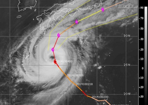
Strong Typhoon Expected to Clip Japan
A strong typhoon dubbed Phanfone spun up in the Northwest Pacific this past week and has significantly strengthened since then. Phanfone, which is currently a strong typhoon bearing winds of 195km/h with a central pressure of 935mb is unlikely to make a direct landfall on the main islands of Japan, unless its tracks shifts slightly north. Even if it does not make landfall it is still expected to bring significant severe weather to the region, including Tokyo. The typhoon which is currently heading directly north is expected to start curving northwest today, helped by prevailing winds. As this happens gradual weakening is expected, however, it’s forecast that at its closest point to Tokyo on Sunday the storm will still have sustained winds of 120km/h, likely bringing tropical storm force winds to Tokyo. These winds, combined with the storm surge and heavy rainfall are likely to cause damage, especially in the mountainous regions that are prone to landslides. In preparation for this storm the Japan Meteorological Agency has issued storm surge advisories and high wave warnings for several coastal communities.

Another tropical disturbance that spun up only a few days ago in the Pacific is also the focus of attention this week, even though is not expected to make landfall on any regions any time soon. Vongfong is only a tropical storm currently, but is organizing and is under fairly good conditions for typhoon strengthening. China, Japan and possibly Taiwan will have to keep an eye on this storm by the end of next week but it is still very early to focus in on any specifics for this storm. The storm is expected to make its way through Guam however, as a typhoon, late this weekend.
