Cool and Rainy Tuesday Brings an End to Late Fall Warmth

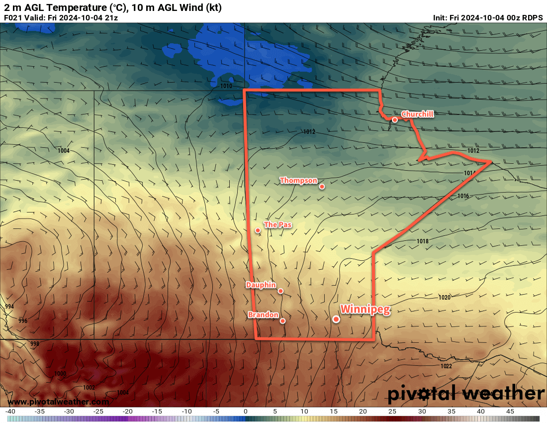
A cold front will bring cool and rainy conditions to southern Manitoba today as it ushers near-seasonal temperatures back into the region.

ECMWF 24hr. Precipitation Accumulation Forecast valid 12Z Wednesday October 23, 2024
Much of southern Manitoba will receive rain from a cold front crossing the region today.

The weather today will be a rather marked change from yesterday. Instead of beautiful sunny conditions with warm weather, a cold front will bring clouds and rain to Winnipeg along with much cooler conditions.

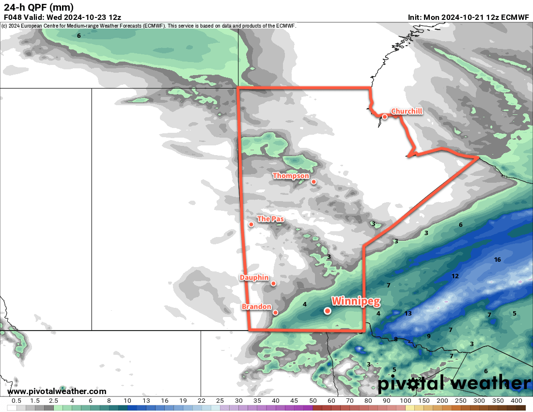
Rain will begin mid-morning today and last into the early afternoon. Winnipeg will likely end up with 5–10 mm of rain before it tapers off, but there’s a small chance that it might drift just a bit north of the city, lowering our amounts. Other than that, moderate northwest winds of 30–40 km/h will spread into the region this morning and persist through the day. These cool winds will send temperatures falling into the afternoon, dipping down to 3 or 4 °C by the end of the work day.

Those northwest winds will continue into the evening. As temperatures fall, lake-effect precipitation is possible off of Lake Winnipeg and Lake Manitoba. As temperatures continue to drop overnight, it could result in a few snow flurries moving through the Red River Valley. The best chance for snow, though, will be in the lee of Lake Winnipeg where bands of lake-effect snow will likely last through the night.

Temperatures will drop to around -1 °C overnight in Winnipeg with winds dying off.

With a ridge of high pressure moving through the region, Wednesday will bring mainly sunny skies as the lake-effect cloud clears out. Temperatures will climb to a high near 10 °C with southerly winds picking back up to around 30 km/h.

A weak frontal wave moving through the region on Thursday night with bring cloudy skies back to the area. This will help keep temperatures a bit warmer; Winnipeg should see an overnight low in the low single digits rather than dipping below freezing. Those southerly winds will also drop off overnight.

Expect clearing skies on Thursday with light northwest winds picking up. Temperatures should again climb to a high around 10 °C. Heading through the night temperatures will dip down to around freezing under clear skies.

Long Range Outlook

A broad area of high pressure will build into the Prairies from the west through the weekend as a weak upper ridge builds in the west. This will bring sunny to partly cloudy skies to southern Manitoba with seasonably mild highs in the 10 to 15 °C range. Overnight lows will range from sub-freezing back to the mid-single digits.

Looking even further ahead, early indications that Halloween this year will be much nicer than last year’s. Rather than temperatures near -9 °C with 20–30 km/h winds making it feel closer to -20, early signs point to an evening with temperatures around +1 °C and winds near 20 km/h. This is obviously subject to change since it’s a ways away yet, but there are few large-scale patterns that suggest we’ll see a drastic snow/cool-down before Halloween this year. Hopefully that forecast can hold!

Today’s seasonal daytime high in Winnipeg is 8 °C while the seasonal overnight low is -2 °C.

Unsettled and Windy Weekend Gives Way to Warmer Weather

After a cold start to Friday morning, temperatures in southern Manitoba will jump back to seasonably warm values, though the weekend will end with blustery conditions and cooler temperatures after rain showers move through on Saturday.

RDPS 2m Temperature Forecast valid 21Z Friday October 4, 2024
Despite a cold start to the day, a low pressure system over the western Prairies will push warmer temperatures back into southern Manitoba today.

Despite a frosty start to the day for many places in southern Manitoba, temperatures will quickly bounce back to above-seasonal values today. A low pressure system developing over the western Prairies will begin spreading warmer air eastwards into Manitoba. Southerly winds will pick up into the 30 gusting 50 km/h range today with sunny skies and an afternoon high in the upper teens. Those winds will continue right through the night as the low tracks through Saskatchewan, keeping temperatures mild with lows in the low teens.

Despite being relatively warm, Saturday will be a bit of an unpleasant day. The main driver for the weather will be a low pressure system crossing through the Interlake, with an energetic cold front that sweeps through later in the day. The day will start with increasing cloudiness as moderate southerly winds continue across the region. Temperatures will climb back into the upper teens as rain spreads into western Manitoba. There’s a small chance of some midday showers in Winnipeg, but the better chance for rain will develop later in the afternoon as a cold front sweeps through. Winds will shift from southerly to westerly and strengthen to 50 gusting 70 km/h as rain wraps into the region.

RDPS 10m Wind Forecast valid 21Z Saturday October 5, 2024
Strong westerly winds will blast through southern Manitoba on Saturday afternoon behind a cold front that sweeps through the region.

The rain will taper off overnight as temperatures head to a low in the mid-single digits. The winds will continue through the night, shifting to the northwest and gradually easing into the 30–40 km/h range by Sunday morning. By the end of the night, the main area of rain will be well to the east of the Red River Valley, but a couple bands of lake-effect showers may linger in the lee of the lakes into Sunday morning.

Sunday will be a cooler day with northwest winds of 30 gusting 50 km/h and a high in the low teens. Skies should clear for the afternoon bringing sunshine back to the region. Temperatures will dip close to freezing on Sunday night with clear skies and easing winds.

Long Range Outlook

Next week will bring warmer conditions back to southern Manitoba as the upper low over western Hudson Bay retreats northwards and upper ridging is able to redevelop over the Prairies. Much of the week will bring daytime highs in the upper teens or low 20s with overnight lows near the 10 °C mark. The week should also be dry with no significant precipitation in the forecast.

Today’s seasonal daytime high in Winnipeg is 14 °C while the seasonal overnight low is +2 °C.

Warm Late-Summer Weather Continues

A persistent southerly flow over southern Manitoba will keep the seasonably warm and humid conditions in place for a for a few more days.

RDPS 2m Temperature Forecast valid 21Z Wednesday September 18, 2024
A stalled low over eastern Montana will continue to pump warmer air northwards into southern Manitoba this week.

A quick note to start: the lack of forecasts last week was due to the fact that I’m dealing with a long-lasting bout of COVID–19 that’s sidelined me for a while now. I’m on a [gradual] up and up now, with symptoms finally receding after testing positive on rapid tests for a whopping 11 days in a row. Not a fun time, looking forward to getting back at life.

Daytime highs in the mid-20s will continue into mid-week for the Winnipeg area as a persistent low pressure complex to the west supports a southerly flow across the region. Daytime highs for Tuesday and Wednesday will likely sit around 25 °C; it could be a touch cooler if a bit of a stronger cold pool is left behind from overnight convection, or a tad warmer if we clear out early and a stronger southerly flow can develop earlier in the day.

The humidity will also be notable for mid-September, with dew point values in the mid- to upper-teens, potentially reaching around 20 °C on Wednesday. This is more humid that the region often sees at this time of year, but the lower daytime highs in the 20s should keep the worst of the heat effects at bay. In the sun, the heat and humidity could combine to feel like it’s in the low 30s rather than mid-20s.

RDPS 2m Dew Point Temperature Forecast valid 21Z Wednesday September 18, 2024
In addition to the seasonably mild temperatures, it will continue to be humid across southern Manitoba.

Overnight lows both tonight and tomorrow night will sit in the mid-teens.

Weather-wise, today should bring clearing skies as the disturbance that brought rain and thunderstorms to the region yesterday pushes off to the east. A few clouds will begin to build back in tonight, leading to mixed skies on Wednesday as a cold front approaches the region from the west.

A few showers are possible on Wednesday; it looks like they should be weak, though the slow-moving nature of the cold front and broad forcing could result in a narrow band of slow-moving showers that could produce some locally higher amounts in the 15 to 25 mm range. I’m doubtful Wednesday will be a “wet” day, more likely a cloudier one with the chance of passing showers.

The cloudiness and chance of showers will continue into Wednesday night.

Unsettled End to the Work Week

The low that’s been sitting to the west all week will finally get moving on Thursday, moving into southwest Manitoba on Thursday and sliding into northern Manitoba on Friday.

This will bring a notable change in the weather to southern Manitoba. To start, both Thursday and Friday could bring wet conditions to the Red River Valley. On Thursday, showers and thunderstorms will begin possible through much of south-central and southeast Manitoba as the forcing along the cold front picks up with the advance of the low. This activity will likely continue into the night as it pushes northeast.

Winds will finally shift on Thursday from the persistent southerly at 20 to 30 gusting 50 km/h seen much of this week to westerly winds of 15 to 30 km/h.

On Friday, showers in the instability on the back-side of this system may clip through southern Manitoba as cooler air moves into the region. Daytime highs will cool into the low 20s by the end of the work week.

Long Range Outlook

Heading into the weekend, more settled conditions will develop over the region as near-seasonal temperatures return. Winnipeg will see partly cloudy conditions over the weekend with daytime highs in the upper teens and overnight lows near the 10 °C mark.

This trend looks to continue into the start of next week.

Today’s seasonal daytime high in Winnipeg is 18 °C while the seasonal overnight low is 6 °C.

Hot Weather Before a Big Cool-Down

There will be a couple more hot days in Winnipeg before a cold front sweeps through the province and ushers in much cooler conditions for a few days.

RDPS 2m Temperature Forecast valid 21Z Tuesday September 3, 2024
Southern Manitoba will have another couple days of warm weather before a strong cold front pushes through the region.

A weak upper ridge building east across the Prairies will bring warm weather to southern Manitoba over the next couple days. In Winnipeg, temperatures will climb to a sunny high near 30 °C today and into the mid-20s on Wednesday. Southerly winds of 30–40 km/h will build into the region today and ease into the 20–30 km/h range tonight. Temperatures will dip down to an overnight low in the upper teens tonight.

A trough of low pressure will move through on Wednesday morning, bringing mixed skies and lighter winds. Skies will clear through the day with northwest winds up to 30 km/h developing for the afternoon. There may end up being a low chance of isolated afternoon showers or thunderstorms, but it does not look likely right now.

A more substantial pattern change will occur on Wednesday night, marked by a strong cold front that pushes into the region overnight. This will bring northerly winds up to 40 gusting 60 km/h to the region as a colder air mass moves in. The cold front will bring a chance of showers to the region on Wednesday night into Thursday morning. Temperatures will head to a low in the low teens on Wednesday night.

Much cooler conditions will move into the region on Thursday, marked by an Arctic high building across the Prairies. Temperatures will struggle back to the mid-teens on Thursday with cloud cover breaking up through the day.

Temperatures will head down into the mid-single digits on Thursday night with clearing skies and easing winds.

Long Range Outlook

Friday will bring more cool weather to the region with sunny skies and a high in the upper teens. It iwll be another cool night with lows in the mid-single digits on Friday

Light southerly winds will redevelop on the weekend, marking the start of a gradual trend towards warmer weather. By next week, the region will be back to daytime highs in the mid- to upper 20s and overnight lows in the low teens.

Today’s seasonal daytime high in Winnipeg is 21 °C while the seasonal overnight low is 9 °C.