Generally Mild Conditions Ahead

While today will start off with some showers as cold fronts usher the above-freezing temperatures out of the region, conditions will remain generally mild with near-seasonal to above-seasonal temperatures expected over the coming week.

Winnipeg will see a mild start to the day with temperatures near +3°C, but that warmth will be short-lived. A cold front sweeping through early this morning will bring a band of showers across southern Manitoba. This front will usher in breezy westerly winds near 30 km/h with gusts up to around 50 km/h. The showers should taper off behind the front, but a second cold front will then drop southwards in the afternoon, bringing with it flurries as the winds shift northwesterly and temperatures drop further to around -1°C by the evening. The flurries will taper off in the evening as the breaks up a bit, leaving mixed skies for the night. Winds will taper off as temperatures drop to a low near -9°C.
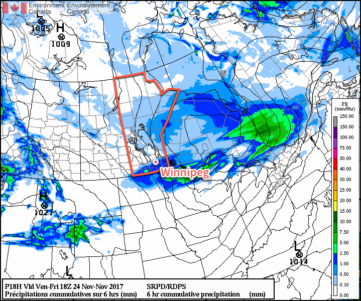
An area of showers will move across southern Manitoba early this morning

Saturday will bring light winds as a ridge of high pressure moves across the Red River Valley, likely with a bit of morning sunshine. Cloud will build back eastwards into Winnipeg in the afternoon though, as the front that dipped southwards through the Red River Valley rebounds to the west and begins pushing back into the Red River Valley again. No snow or rain is expected in the Red River Valley; any precipitation will be further north, close to a low pressure system crossing through central Manitoba. Temperatures will climb towards a high near -2°C as the cloud moves into the region, and winds will pick up out of the south to around 20 km/h. Expect skies to remain mostly cloudy on Saturday night with temperatures remaining near -2 or -1°C for much of the evening, then dropping to a low near -5°C overnight as a weak cold front slumps through, shifting winds northwesterly and bringing in cooler air.

Sunday will bring mostly cloudy skies to the region yet again as temperatures remain steady near -4°C for much of the day. Another ridge of high pressure will be moving across the province, so winds will remain light throughout the day. Skies will remain cloudy on Sunday night as another warm front approaches from the west. Temperatures will climb towards -1°C by Monday morning with increasing southerly winds to 20 to 30 km/h.

Long Range Outlook

Looking ahead, Monday looks mild but may bring rain or snow to the region as another significant low pressure system crosses through the central Prairies. Afterwards, a zonal flow persists over the Prairies bringing multiple disturbances through the week that will bring occasional chances for flurries. Temperatures will remain near-seasonal to above normal, with relatively mild temperatures expected to remain in place for much of next week!

Winnipeg’s seasonal daytime high is currently -5°C while the seasonal overnight low is -13°C.
Unsettled Climb Towards Warmer Weather

Temperature will trend towards the milder side over the coming few days in Winnipeg as an upper-level ridge builds into the eastern Prairies. The warmer weather will come at a cost, though, with sunshine becoming somewhat of a scarce commodity in the second half of the work week.

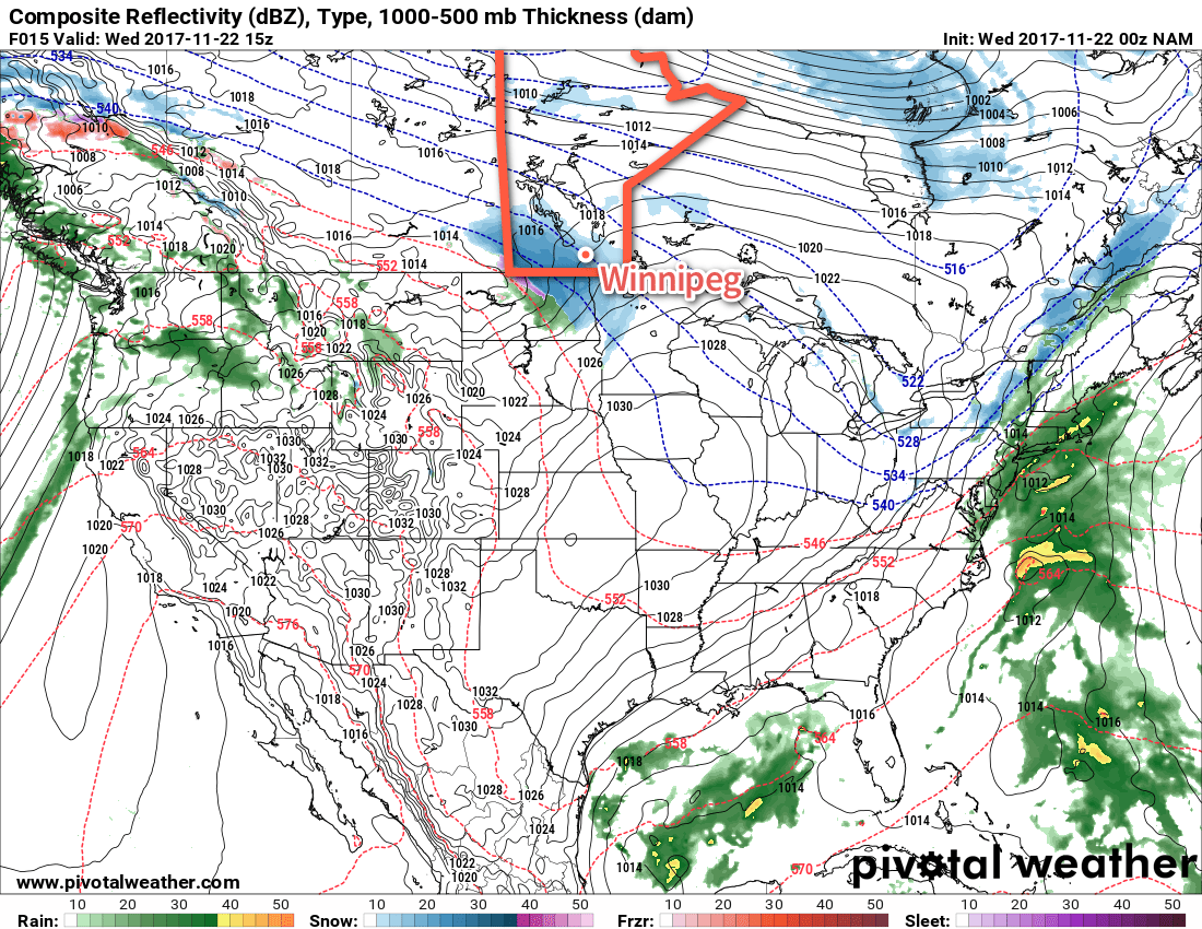
Today will start off with skies clouding over quite early as an upper-level disturbance slides southeastwards from Dauphin into the southern Red River Valley. As it moves through, it will spread an area of light snow through the Parkland, across southwestern Manitoba, and into the southern Red River Valley. Winnipeg will be on the northeastern edge of the main area of snow and will see some non-accumulating light snow. Under the main snow track, snow will still be fairly light, with just 1 to 2 cm expected to fall. The snow will taper off in the afternoon as temperatures reach a high near -7°C, then skies will clear out in the evening as temperatures head to a low near -14 or -15°C.

NAM Forecast Precipitation Rate & Type valid 15Z Wednesday November 22, 2017
Some light snow will clip across southern Manitoba this morning

Thursday will see cloudy skies move into the Red River Valley early in the morning as a warm front pushes eastwards into the province. Temperatures will climb back to near-seasonal values through the day, reaching near -3°C by late afternoon. Those warmer temperatures will also come with increasing southerly winds increasing to 20 to 30 km/h in the afternoon. Skies will remain cloudy overnight with temperatures continue to rise, reaching +1°C or so by Friday morning. Winds will ease slightly to around 20 km/h for the night after the warm front passes through.

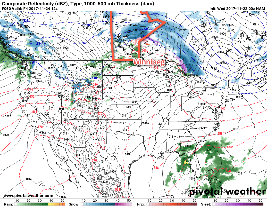
NAM Forecast Precipitation Rate & Type valid 12Z Wednesday November 24, 2017

Friday will be very mild in Winnipeg with temperatures reaching a high near +3 or +4°C. Showers will be possible as a cold front sweeps through in the morning, ushering in breezier westerlies of 30 to 40 km/h. The chance of showers will continue into to the afternoon, then switch to light snow as a second trough of low pressure swings through. After that, winds will switch to the northwest at around 40 gusting 60 km/h and temperatures will begin falling back below freezing to a low near -8°C with flurries and breezy northwesterlies continuing.

Long Range Outlook

Taking a quick look ahead to the weekend, it looks like Winnipeg will see near-seasonal temperatures with variable cloudiness. Saturday should see some sunshine while Sunday may see more of a mixed to mainly cloudy sky. All in all, relatively pleasant for late November!

Winnipeg’s seasonal daytime high is currently -4°C while the seasonal overnight low is -12°C.

Alberta Clipper Brings Mild Temperatures Quickly Followed By Windy Blast of Arctic Air

An Alberta clipper tracking across the province will bring above-freezing temperatures to Winnipeg today, but strong northwesterlies will usher in colder temperatures this evening that will remain in place for much of the week.

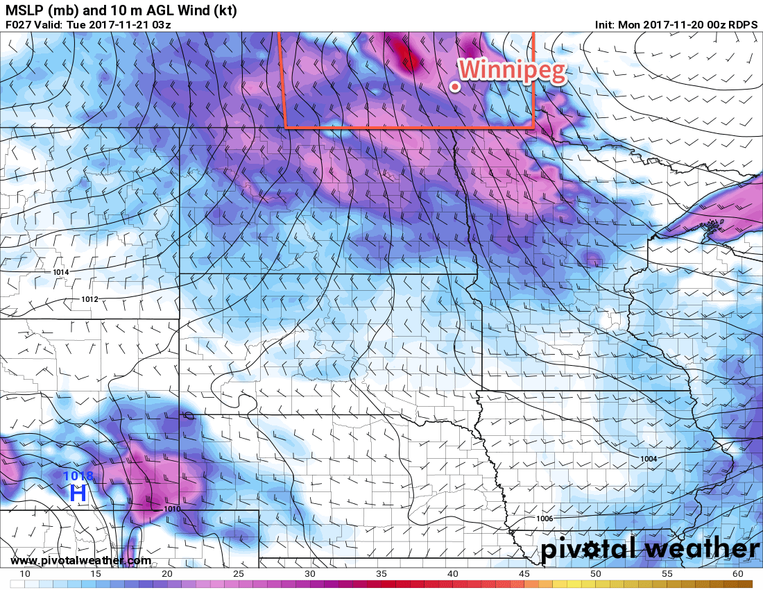
Mild temperatures are on the way today as an Alberta clipper tracking through the Interlake spreads above-freezing temperatures along and south of the Trans-Canada corridor. Temperatures will reach a high near +1°C this afternoon with some rain showers developing across portions of the Red River Valley. Winds will shift from southerly near 20 km/h to westerly at 30 gusting to 50 km/h mid-afternoon, and then shift to northwesterly behind a cold front that sweeps through between 5 and 7PM, ushering in strong winds of 40-50 km/h with gusts up to 70 km/h. By then, any precipitation will switch over and fall as snow. Although snowfall is not expected to be particularly intense, the combination of snow with strong northerly winds will likely produce some areas of reduced visibility in blowing snow.

RPDS 10m Wind Forecast valid 03Z Tuesday November 21, 2017
Strong northwesterly winds of 40-50 km/h will develop over the Red River Valley on Monday evening

With the northwesterly winds, temperatures will rapidly plummet in the evening, going from near +1°C at 5PM to -7 or -8°C by midnight. This rapid drop in temperatures combined with light snow and strong winds will result in a rapid freeze, likely producing slippery roads and poor driving conditions. If you must travel tonight, be sure to give yourself extra time, drive safely, and ensure you have an emergency car kit with you. Any remaining light snow will taper off towards early Tuesday morning as temperatures head to a low near -10°C.

Tuesday will see morning northwesterlies near 30 gusting 50 km/h gradually taper off through the day as a ridge of high pressure moves in. Temperatures will be cool with highs near -7°C under mixed skies. Even cooler air will move in on Tuesday night as the ridge of high pressure moves into the Red River Valley, sending lows into the -15 to -20°C range, depending on exactly how much cloud cover remains in the region.

Winnipeg will see cloudy periods on Wednesday as a weak upper-level disturbance bringing a few light flurries to south-western Manitoba spreads cloud into the Red River Valley. Winds will continue to be light under the ridge of high pressure and temperatures will reach a high near -7°C once again. Expect clear skies and a low near -14°C on Wednesday night.

Long Range Outlook

The remainder of the week looks cool for the most part; a low tracking across the central Prairies on Friday will bring mild temperatures once again, but cooler temperatures crash back southwards in the northwesterlies behind the system on Friday night. Cooler temperatures look to stick around through the weekend into next week under variable cloudiness.

Winnipeg’s seasonal daytime high is currently -3°C while the seasonal overnight low is -12°C.

Cool Conditions Give Way to Milder, Unsettled Weather

Winnipeg will be offered a reprieve from yesterday’s snow and harsh wind as with temperatures set to rebound towards seasonal values over the next couple days. The region will see increasing cloud through the weekend, though, as another low pressure system will bring some light snow and rain to the province Saturday night into Sunday.

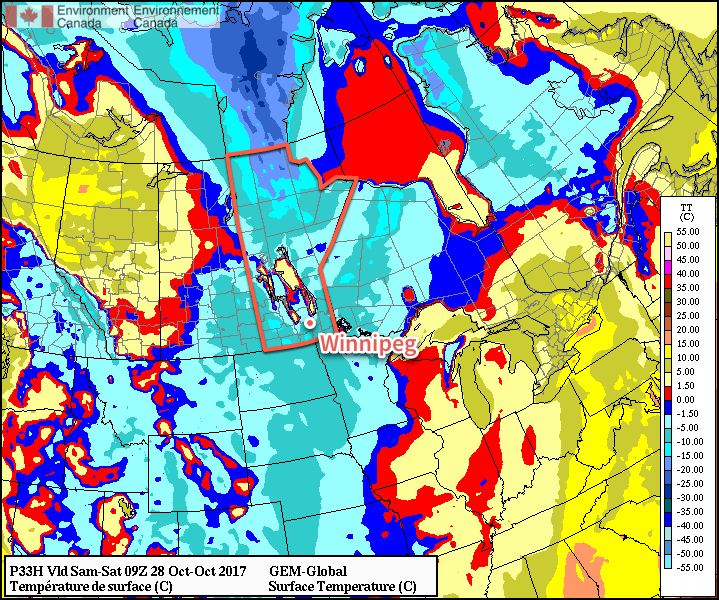
The sun will be back today in WInnipeg as a ridge of high pressure building southwards clears out the remaining clouds from yesterday’s storm system. Temperatures will slowly climb back above freezing or a high near +2°C this afternoon. While that’s a bit below-seasonal, the absence of any wind will be a welcome change. Skies will remain clear tonight, but the ridge of high pressure in place will send temperatures well below-seasonal tonight with lows of -6 to -10°C through the Red River Valley and southern Interlake.

Temperatures will fall well below zero across much of southern Manitoba tonight

Saturday will see seasonably cool conditions in Winnipeg for the last Blue Bomber’s regular season home game. Winnipeg will see a mix of sun and cloud as warmer air spreads eastwards across the Prairies ahead of a low pressure system sliding southeastwards from Yellowknife, NWT. Temperatures will reach a high near 3°C with light winds.

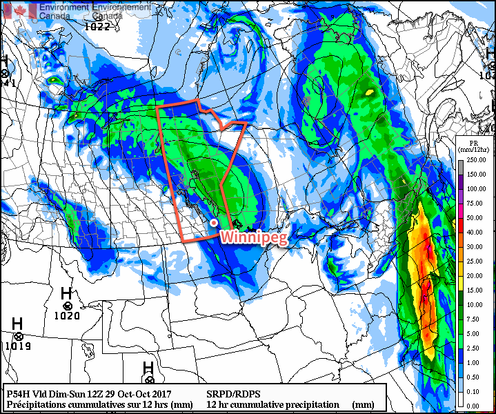
Skies will cloud over late in the afternoon or early Saturday evening with a mix of snow and rain moving into the Red River Valley from the north. As the evening progresses there will be a continued chance for showers.1 Temperatures will dip to a low near +1°C with winds increasing out of the south to 20-30 km/h.

A low pressure system dropping southeastwards from the Northwest Territories will spread rain and snow across Manitoba on Saturday night

Sunday will start with a cold front swinging through the Red River Valley, bringing with it some morning showers and shifting winds to the northwest at 30-40 km/h. There will be a slight chance of showers through the remainder of the day after the cold front passes, but it appears much of the precipitation associated with this system will remain further north and east of Winnipeg, along a the track of the low moving through the province: from Swan River southeastwards through the central Interlake and into southeastern Manitoba. Temperatures will reach a high near 6°C.

Sunday night will continue to be overcast with an increasing chance of rain changing to snow through the night as the precipitation that is north of the Red River Valley slumps southwards. Temperatures will dip to a low near -1°C with winds remaining out of the north at 30-40 km/h.

Long Range Outlook

Monday will likely bring some morning snow giving way to cloudy skies and a high near freezing with breezy north winds continuing. It looks quite likely that lake-effect snow will develop off of Lake Manitoba and Lake Winnipeg, potentially bringing accumulating snow to the regular places: near Portage la Prairie and southwards along the western escarpment, and south of Lake Winnipeg towards Beausejour. Of course, exactly where sees these bands of snow will depend significantly on the exact wind direction, so it’s a bit early to say much of whether or not Winnipeg will be impacted.

The remainder of the week looks cool and will bring several chances for flurries as multiple disturbances move through.

Winnipeg’s seasonal daytime high is currently 6°C while the seasonal overnight low is -4°C.

  1. Snow will only be likely in the early evening; increasing amounts of warm air aloft combined with surface temperatures above zero should provide enough warmth to favour rain.