More mild weather lies ahead for Winnipeg, but unfortunately the sun will be in short supply as plenty of cloud stick around for the next few days.
Today will bring plenty of cloud cover to Winnipeg as a disturbance in the Northern Plains spreads cloud cover eastwards across Southern Manitoba. Temperatures will climb to a high near 8°C with winds picking up out of the north to around 20 km/h. A chance for light rain will develop for the afternoon and evening as the disturbance slowly moves by. Temperatures will dip to a low near 0°C tonight. Winds will remain out of the north with cloudy skies.
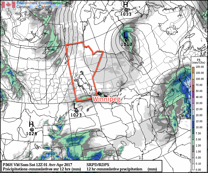
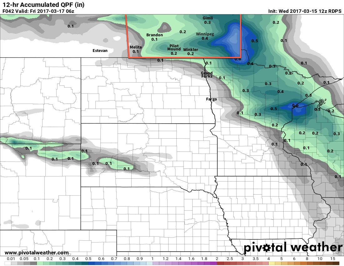
Models depict a small area of rain spreading across southern Manitoba on Friday ngiht.
Saturday will be a bit more pleasant with a high once again near 8°C, but the cloud cover will break up and give Winnipeg more of a mix of sun and cloud. Winds will remain light. On Saturday night the skies will cloud back up as the temperature drops to a low near 5°C.
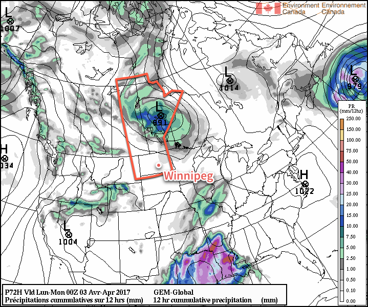
Sunday will bring cloudy skies back to Winnipeg as a low pressure system tracks across Central Manitoba. Winds will strengthen out of the south to 30-40 km/h ahead of the low with temperatures climbing to a high near 11°C.
GDPS 12hr. QPF valid 00Z Monday April 3, 2017
There looks to be a fairly good chance for showers midday and into the afternoon as a weak cold front pushes through the region. Expect temperatures to drop to a low near +2°C on Sunday night under clearing skies. Winds will diminish and back to westerly.
Long Range
The long-range forecast looks great with nothing but above-normal temperatures and mainly dry conditions for next week.
Winnipeg’s seasonal daytime high is currently 5°C while the seasonal overnight low is -6°C.
As advertised earlier in the week, milder weather arrives to the Red River Valley today, however unlike earlier in the week, conditions have trended towards being more unsettled with several chances for rain.
Today will be mild with temperatures climbing to a high near 11°C, but that warmth comes ahead of a disturbance that will bring a chance of showers to the the Red River Valley later today. Winds will be out of the southeast at around 30 km/h, and both the chance of showers and the wind will persist into the evening. Expect a low near 3°C tonight.
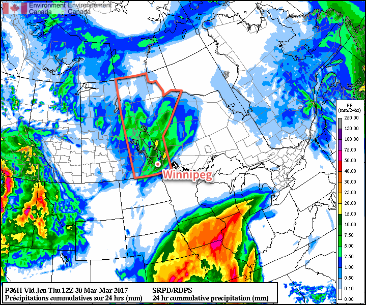
The chance for showers will come in two batches, the first very early this morning as overnight development slides through, and the second builds over southwest Manitoba this afternoon and then slides eastwards into the Red River Valley late in the afternoon and into the evening. This second band may persist for a while and feature some moderate rainfall rates, although widespread accumulations will likely remain under the 5-10 mm range.
Much of Manitoba will see showers or light rain from the system moving through.
Thursday will see a similar high to today, but a bit of sunshine should help it feel a bit nicer. Temperatures will reach a high near 11°C as winds taper off in the afternoon. Thursday night will bring increasing cloud as temperatures dip to a low near 4°C.
Friday will be a bit cooler with a high near 8°C under mainly cloudy skies. Winds will gradually increase out of the north to around 20 km/h as a weak ridge of high pressure approaches from the northern Prairies. There looks to be a fairly good chance of some light rain on Friday night as temperatures drop to a low near 2°C.
Long Range
The weekend looks to be a bit of a mixed bag; temperatures will continue mild with highs near the 10°C mark, but skies will bring variable cloudiness and some of Friday night’s light rain may stick around for portions of Saturday morning.
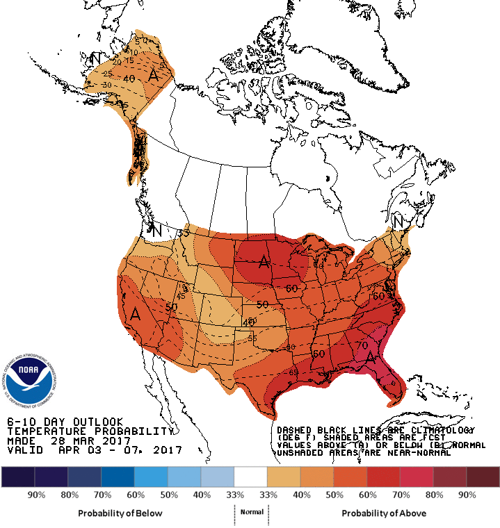
CPC 6-10 Day Temperature Anomaly Outlook valid April 3-7, 2017
Looking further ahead into next week, there’s a very high chance that we’ll continue to see above-normal temperatures in southern Manitoba. No significant precipitation is expected next week either, so we should see a continued, gradual melt across the region.
Winnipeg’s seasonal daytime high is currently 4°C while the seasonal overnight low is -7°C.
The weekend will bring a mixed bag to Winnipeg with temperatures climbing into above-seasonal values, but a fair amount of cloud will remain in place over the next few days, dampening the spring-like feeling.
Cooler temperatures will be in place over the Red River Valley today as a result of northerly winds to 20-30 km/h that moved in behind a cold frontal passage overnight. Temperatures are expected to reach high near +2°C in Winnipeg today as those winds diminish by midday. Skies will become a mix in the morning and remain that way through much of the remainder of the day.
Skies should clear up tonight as temperatures drop to a low near -5°C.
Milder temperatures are expected across southern Manitoba on Saturday.
Saturday will bring slightly milder temperatures to the region, but alongside the warmth will come breezy southerly winds to around 30 gusting 50 km/h. Temperatures will climb to a high near 4 or 5°C with skies clouding over. Saturday night will bring diminishing winds, cloudy skies and a seasonally mild overnight low near 0°C.
Sunday will be similar temperature-wise to Saturday with a high temperature near 5°C, but a trough of low pressure moving into the Red River Valley will bring lighter winds and the chance for some rain showers. Skies will clear a bit overnight as temperatures head to a low near 0°C once again.
Long Range
As mentioned in our last post, the forecast for a continued trend of gradual warming continues. Little has changed from our outlook earlier in the week, with above-normal temperatures expected in most places over the coming couple weeks.
Winnipeg’s seasonal daytime high is currently 2°C while the seasonal overnight low is -8°C.
Springtime warmth will arrive in Winnipeg as temperatures climb above the freezing mark, but the warmer weather will be accompanied by some rain and snow as a low pressure system moves through the region.
Today will be a very pleasant day in Winnipeg with sunny skies in the morning giving way to mixed skies with temperatures climbing to a high near -2°C.1 Winds will pick up out of the south to around 30 km/h this afternoon. Tonight will bring increasing cloudiness overnight as temperatures drop to a low near -5°C with southerly winds continuing at 20-30 km/h.
Tomorrow will be the mildest day of the next few as an approaching low pressure system moves through the region. Skies will be mainly cloudy to start the day and continue to be cloudy for the remainder of the day. A warm front will move across the Red River Valley through the afternoon, bringing milder temperatures as highs climb to around the +3°C mark. Along with the warmer weather, rain will spread across the Red River Valley in the afternoon with the warm front.2 It appears at this point that the Red River Valley will likely receive 2-4 mm of rain, so nothing too dramatic, although there are some models indicating the potential for 10-15 mm.
The RDPS model is a bit more enthusiastic than the other models, producing around 10mm of rain in the Red River Valley.
The light rain will end in the evening, followed quickly by the winds diminishing. The cloudy skies and warm air over the Red River Valley will keep overnight lows fairly warm, with Winnipeg dropping to around 0°C for a low. Towards early Friday morning, winds will then pick back up out of the northwest as the cold front swings through, which will bring cooler temperatures back into the region.
Friday will continue with mainly cloudy skies and fairly strong northwesterly winds to 40-50 km/h. Temperatures will remain steady near 0°C as any diurnal warming will be offset by the cooler air mass moving into the region. Throughout much of the day there will a decent chance for light snow, but no accumulations are expected at this point.
Friday night will bring diminishing winds, clearing skies, and cooler temperatures with overnight lows dropping to around -14°C.
Long Range
The weekend is looking quite pleasant with partly cloudy skies both Saturday and Sunday and high temperatures climbing back to above normal. At this point, Sunday is looking like it could be quite warm with highs in the 4-8°C range, although those warmer temperatures would likely come with a decent southerly wind. The hope at this point is that any precipitation associated with this warm-up will move across the central and northern Prairies, leaving us dry.
Into next week it looks like a return to near-seasonal temperatures and dry conditions.
Winnipeg’s seasonal daytime high is currently -1°C while the seasonal overnight low is -11°C.
While our high is forecast for the airport location, it's quite likely several sites across Winnipeg see high temperatures closer to +1 or +2°C. ↩
There's a chance that the early stages of the precipitation fall as snow if temperatures haven't warmed quite enough yet, but the transition to rain would follow quickly. ↩