Unsettled Weekend Ahead; Soggy Sunday?

Southern Manitoba will be under the influence of a complex low pressure system this weekend that will spread multiple bands of precipitation across the province. Things are a little uncertain for Sunday – Father’s Day and the Manitoba Marathon – but it’s looking probable that it may be quite wet.

Friday
21°C / 12°C
Increasing cloud; chance of afternoon showers. 5-10mm of rain overnight.

Saturday
18°C / 14°C
Cloudy; some light rain or drizzle possible.

Sunday
18°C / 10°C
Rain likely; up to 20mm.

Today will be a relatively nice day. Cloud coverage will gradually increase and there will be a slight chance of showers in the Red River Valley this afternoon as rain spreads eastwards across southern Manitoba. The temperature will climb to around 21°C.

Showers will move into the Red River Valley through the evening with around 5-10mm falling. While there may be an odd rumble of thunder, overall the thunderstorm threat is low to non-existent. Rain will move from southwest to northeast and lift into the Interlake region, leaving us with overcast skies by morning. The low temperature will sit near 12°C.

Total expected rainfall for the first wave of rain today through tonight into Saturday morning.

Saturday will be a mainly cloudy day with some showers or drizzle likely. It doesn’t look too wet, but overall it will be sort of a dreary day with sporadic precipitation. Further north, through the Parkland region eastward into the Interlake, there will likely be rain for much of the day. The high temperature will be near 18°C and expect the temperature to drop to around 14°C on Saturday night.

Uncertain Sunday

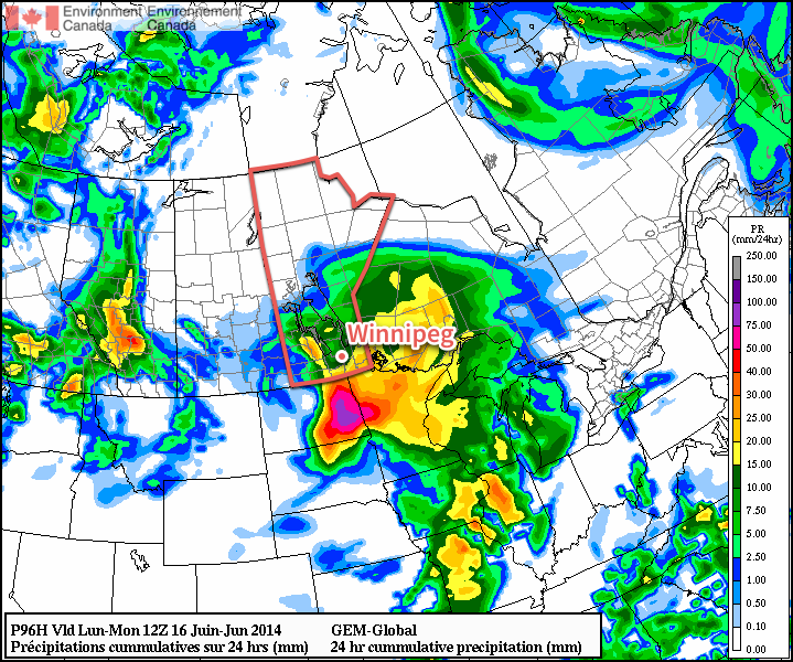
Sunday, which marks Father’s Day and the ever-popular Manitoba Marathon, has a little more uncertainty associated with it. The general weather picture shows a stalled out low pressure system over SE Saskatchewan and SW Manitoba while a Colorado low lifts northwards through the Dakotas. The evolution of the feature is very complicated, and small changes in the upper-level flow could mean big changes to the expected weather over Southern Manitoba. I’ll give the most likely solution right now, and leave updates in the comments below if it looks like an alternate solution becomes more plausible.

The GDPS is forecasting a very wet Sunday with 10-20mm of rain through many areas of Southern Manitoba.

Sunday morning will provide a cloudy start to the marathon with some scattered showers or drizzle about. The temperature should be around 15°C. By mid-day, more concentrated shower activity will push northwards through the Red River Valley, with an area of rain covering much of southern Manitoba (save for locations near the Saskatchewan border) by early-to-mid afternoon.

The rain will persist into the evening and taper off by Monday morning. Total rainfall amounts are quite variable, but overall it seems like 10-25mm is possible in most regions, with higher amounts near the US border through SE Manitoba and along the western escarpment of the Red River Vally northwards into the Riding Mountains. Anywhere from 25-40mm seems possible in these areas.

The temperature will drop to around 10°C on Sunday night after the rain tapers off.

Unsettled Pattern Continues

Next week is looking fairly unsettled as yet another major disturbance takes up residence on the Prairies. In general, more cloud than sun will be seen through the week. Heavy rainfall will set up in Alberta on Monday, and as the system develops it looks like a large area of convection will develop across the Northern Plains and lift northwards into the southern Prairies, including Winnipeg and the Red River Valley, by mid-week.

It’s a long ways off, though, so we’ll take a closer look later in the weekend when things become a little more clear.

Rain Brushes Southern Manitoba

A powerful low pressure system drenching North Dakota and Minnesota will brush the southeastern portion of the province today. For the rest of us, fairly quiet weather will prevail with slightly below-normal temperatures.

Wednesday
17°C / 8°C
Mainly cloudy. Outside chance of some light showers.

Thursday
18°C / 6°C
Mainly sunny.

Friday
23°C / 13°C
Sunny, then increasing cloud late in the day.

The main weather story today will be the low pressure system working its way through North Dakota and Minnesota. Although this system will spread cloud through the entirety of the Red River Valley, rainfall will be constricted to the southeastern portion of the Red River Valley into SE Manitoba. At this point, it looks like the main area of rain will remain south and east of Steinbach. There’s a slight chance of showers backing into Winnipeg and the SW Red River Valley (Altona, Winkler), but if any precipitation managed to push that far north or west, it would remain very light.

Forecast rainfall amounts for the system clipping southeastern Manitoba through June 11th and 12th.

Otherwise, it will be a mainly cloudy day with perhaps a few sunny breaks through the first half of the day. Winds will be a little breezy out of the north at 20-30km/h. Temperatures will top out around 17°C. Clouds will begin to push off to the east overnight, however the bulk of the RRV won’t see complete clearing until Thursday morning. Overnight lows will be near 8°C.

Cool But Pleasant End to the Week

Thursday and Friday both look to be quite nice, with temperatures some 5°C below normal returning to seasonal values. Thursday will see clearing skies as temperatures climb to 18°C. Winds will be light out of the north as a ridge of high pressure begins working its way eastwards into Manitoba. There may be a slight chance of some shower or thundershower activity over western Manitoba, but here in the Red River Valley things look sunny and dry. The overnight low on Thursday will generally sit around 6°C; this will likely be the coolest night for the next while.

Friday will be another mainly sunny day with warmer weather returning as the ridge of high pressure shunts off to the east and a southerly flow redevelops over the province. Under mainly sunny skies the temperatures will climb to near 23°C. Cloud will move into the Red River Valley late in the afternoon or the evening and the next system pushes into southwestern Manitoba. Temperatures will drop to around 13°C.

Unsettled Weekend

This weekend will be marked by unsettled weather as a major low pressure complex moves into Southern Manitoba and the Northern Plains of the United States. Rain, with the chance of thundershowers, will push into southwestern Manitoba on Saturday morning. There’s uncertainty as to what will happen after that, but at the time it appears that rain will likely slide eastwards along the international border through the day.

GDPS 24hr. precipitation amounts from Saturday evening to Sunday evening. The GDPS is forecasting 5-10mm of rain in the RRV for this period, with higher amounts west, south and east.

Afterwards, the general trend looks to be a shift northwards with the precipitation towards the northern Red River Valley, and then things push out late in the day on Sunday. Daytime highs on the weekend should rest in the low 20’s while overnight lows hover near the 11-12°C mark.

Warm Weather to Continue

Seasonal to above seasonal weather will continue this week, a nice change from the miserable first part of May.

There will likely be a chance of thunderstorms in southern Manitoba on Tuesday

Monday

Monday
24°C / 13°C
Mix of sun and cloud

Today will feature much calmer weather than what was experienced on the weekend. High temperatures will be in the low to mid twenties in southern Manitoba under a mix of sun and cloud. The wind will generally be light and from the north or east.

Tuesday

Tuesday
27°C / 15°C
Mix of sun and cloud with risk of a thunderstorm

The threat for thunderstorms will resume in southern Manitoba on Tuesday. At this point there is still a lot of uncertainty as to how the thunderstorm risk will evolve. At the high end, there could be numerous severe storms, and even a slight tornado risk. At the low end, storms would likely just produce small hail and gusty winds. It’s too early to say what the storm mode will be on Tuesday, but bear in mind that severe storms are a possibility. The chance of thunderstorms on Tuesday will make the temperature forecast a bit uncertain as well. If there are no storms, and therefore no additional cloud cover, then we’re looking at temperatures in the upper twenties. However, if there is additional cloud from thunderstorm activity, then highs will probably be in the mid twenties. More details on Tuesday’s potential for storms will no doubt be found in the comments below over the next couple days.

Wednesday

Wednesday
25°C / 16°C
Mix of sun and cloud with risk of a thunderstorm

Wednesday is another tricky forecast, as rain may or may not affect the forecast again. Some weather models bring an area of rain and thunderstorms through southern Manitoba in the morning, which would greatly impact the temperature forecast. Like Tuesday, it’s too early to say if this will happen, but it’s certainly a possibility. High temperatures in the mid twenties look most probable, but that outlook could change depending on what happens with the chance of rain.

Long Range

The long range forecast continues to look stormy through the end of the week. Most weather models suggest that there will be a risk of severe thunderstorms in southern Manitoba on Thursday and/or Friday. I feel like I’m saying this a lot, but there is still a lot of uncertainty in this part of the forecast. Models are still not correctly resolving the speed of this system, and until that happens it will be tough to say much about the thunderstorm potential with any certainty. Beyond this week, the weather will likely stay near, to slightly above seasonal values, a nice way to transition into June!

Another Week, Another Rainstorm

The final day of the Victoria Day long weekend will see rain over much of southern Manitoba. It seems that early-week rain is becoming a new tradition of sorts.

A low pressure system will bring rain to much of southern Manitoba on Victoria Day

Monday

Monday
16°C / 9°C
Periods of rain.

A low pressure system moving out of the northern United States will bring moderate rain to most of southern Manitoba today. Accumulations of 5-15mm are expected in Winnipeg and the Red River Valley. Areas further west, in south-western Manitoba, can expected accumulations of 15-25mm. There’s a slight chance of a thunderstorm in areas near the international border, but they should amount to little more than a rumble or two and slightly heavier rainfall.

Tuesday

Tuesday
13°C / 10°C
Showers.

The low pressure system from Monday will remained stalled out over southern Manitoba on Tuesday. That means we’ll see showers continue through the day on Tuesday, but actual rainfall accumulations will generally be light.

Total rainfall expected from Sunday evening to the time everything tapers off on Tuesday evening.

Wednesday

Wednesday
16°C / 4°C
Mainly sunny.

The weather will finally begin to relent on Wednesday, as skies clear and temperatures climb into the mid or upper teens. There will be a breezy north wind on Wednesday, but it will be a nice day overall. Wednesday’s return to reasonable weather signals a major pattern change that is expected to bring much warmer conditions by the weekend.

Long Range

The long range forecast is finally looking hot for a change. Medium-range weather models suggest we could reach the upper twenties, or near thirty degrees by the weekend. There’s still some uncertainty in terms of how hot it will get, but it definitely looks like some above normal weather is finally on the way!