A Glancing Blow

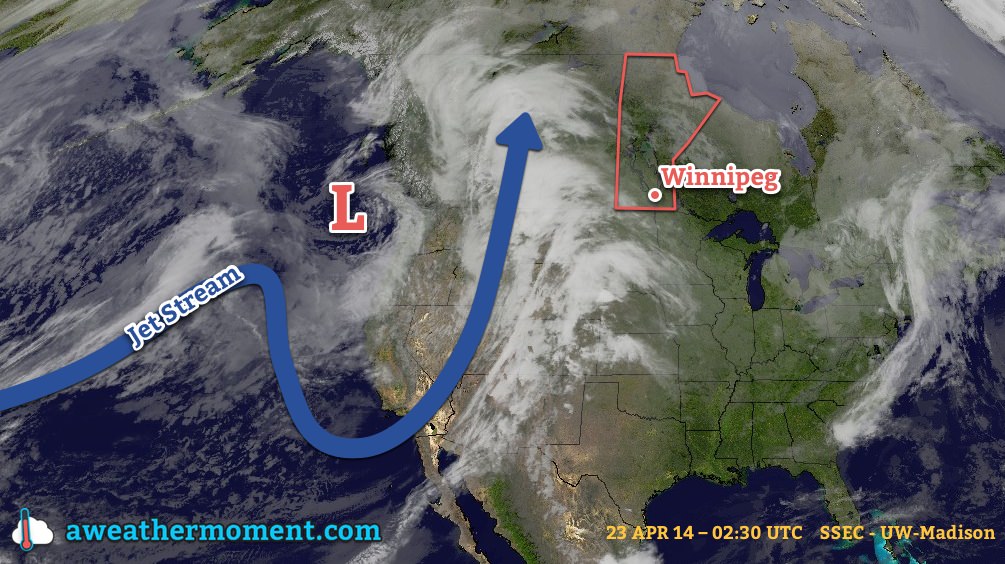
A Colorado low responsible for a tragic severe weather outbreak yesterday across the the Southern United States, and Arkansas in particular, has spread rain northwards into Southern Manitoba this morning. A decent soaking is in store today and then see a cooler, unsettled week ahead as the Colorado Low persists through much of central North America.

Monday
8°C / 0°C
Periods of rain ending by the evening. 10-15mm. Breezy.

Tuesday
10°C / 0°C
A few clouds.

Wednesday
7°C / 0°C
Showers likely.

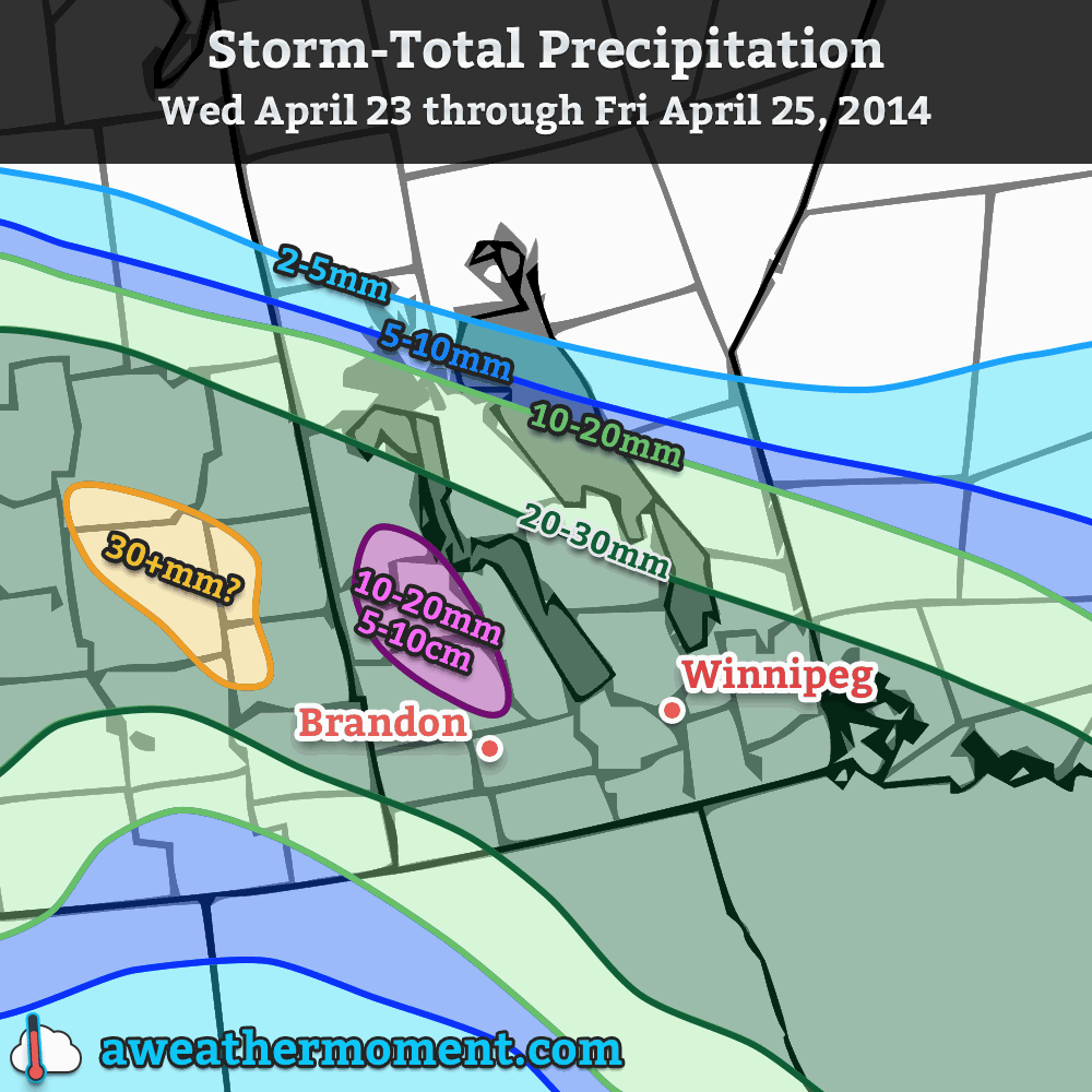
Late last week it looked as if we were set to get as much as 25-30mm in a widespread swath through much of Southern Manitoba, however we pointed out the complexities of the setup and how minor changes in the positioning of features could cause big changes in how much precipitation is produced.

It turns out the models did fairly well with the overall picture. Thanks to a little more tilt to the upper trough and the upper low being captured a little sooner than originally forecast, the system as a whole won’t push as far northwards as it looked last week and as a result we’ll see a little less rain than it looked like then.

We’re still in for a decent soaking today, though. Periods of rain will persist through the late afternoon or early evening, and in general much of Southern Manitoba will see 10-20mm of rain. Areas further north, towards the Interlake and much of Parkland Manitoba will see in the 5-10mm range, but it does appear that, for the most part, anywhere along and south of the Trans-Canada corridor in SW Manitoba and the Red River Valley will see between 10 and 20mm with the higher amounts closer to the U.S. border. The temperature will sit around 8°C today with breezy winds out of the east at 30km/h with gusts to around 50km/h.

Total rainfall expected today across Southern Mantioba.

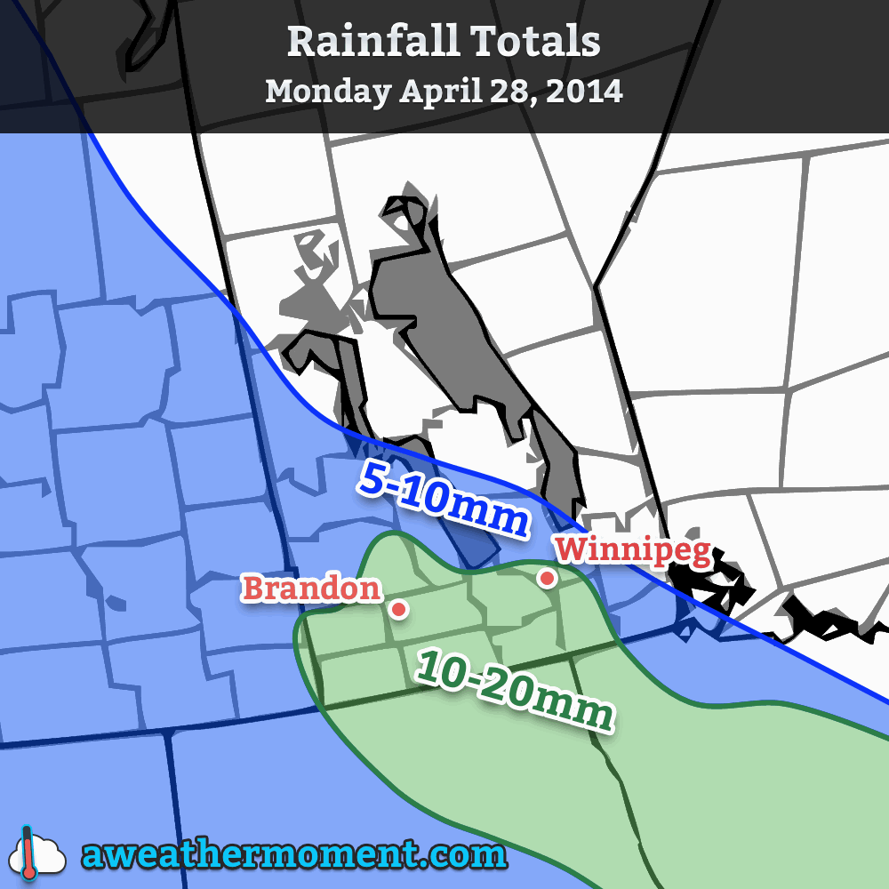
Near the border there’s a slight chance of accumulations creeping up towards 25mm (1”) or so, but that will depend on fairly heavy rain and some lingering rainfall a bit longer than it seems like it’s likely too. The rain will taper off by this evening and we’ll see gradual clearing through the evening. The temperature will drop to around 0°C.

Another Short-Lived Break

Tuesday looks to be a cool but pleasant day with a high temperature of around 10°C and mostly sunny skies. Temperatures will drop to around 0°C once again on Tuesday night with increasing cloudiness.

Wednesday brings back the showery weather as another shot of rainfall pushes into Southern Manitoba from east to west on the back-side of the Colorado Low. Accumulations don’t look significant at this point, perhaps 3-5mm on the high end, but it does seem like it will be a cool, dreary day with a high of only around 7°C. The showers should taper off by the evening as we drop to the freezing mark yet again, this time under cloudy skies.

Where’s Summer?

Unfortunately, not here. Below-normal temperatures are once again forecast for the 7-14 day outlook, meaning we’ll likely see high temperatures only in the high single digits or low teens for the next week or two.

But it’s gotta warm up eventually, right? Right? Here’s hoping for a big turnaround in May.

Spring Storm Incoming

A potent storm system is on the way.

A large spring storm will bring the most significant rainfall to the Red River Valley since last October. It will be mainly rain that falls over the next couple days, however higher-terrain areas of Parkland Manitoba will likely see snow feature more predominantly. This system will be fairly long-lasting, too, with precipitation pushing into SW Manitoba this morning and lingering through Friday.

Wednesday

Wednesday
11°C
Increasing cloud.
Wednesday Night
3°C
Rain beginning in the evening. 5-10mm.

The wet weather over the next couple days is being caused by a strong upper-level trough (depicted in the picture at the top of this post) that is pushing inland from the Pacific. This feature will spawn an elongated trough of low pressure with embedded low pressure centres within it that spans all the way from Alberta through Saskatchewan, Manitoba, and southwards to Texas. This large feature will be aided by an upper-level low tracking along the Canadian/US border which will amplify the precipitation through the Canadian Prairies.

So, what will we see? Rain will spread into southwestern Manitoba this morning and slowly – quite slowly, actually – spread eastwards through the day towards the Red River Valley. By the afternoon, rain should push into the western RRV, but likely won’t reach Winnipeg and into the eastern RRV until late this afternoon or into this evening. By the evening, most areas across Southwest and Parkland Manitoba will likely see around 10-20mm of rainfall, with the potential for some localized amounts of 20-25mm.

Rain will continue to push eastwards through the night, bringing fairly steady rain to most areas in Southern Manitoba. Areas in extreme southwestern Manitoba may see things taper off as the main axis of rain begins shifting to the northeast. Another 5-10mm of rain will fall in most places, however in higher elevations of Parkland Manitoba the rain will switch over to snow overnight with 5-10cm of accumulation possible.

Thursday

Thursday
5°C / 0°C
Rain. 10-20mm.

Thursday will see rain tampering off in Southwest Manitoba, but being reinvigorated over the Red River Valley and Interlake by another shot of moisture lifting northwards along the trough line. Here in the RRV around another 5-10mm will fall, however portions of the valley into the Whiteshell may end up seeing 10-15mm if the heavier rain arrives a little earlier.

Storm-total precipitation expected from Wednesday through Friday.

Light rain will persist through much of Thursday night and perhaps become mixed with snow as we approach our low temperature of around 1°C. Another 2-5mm of precipitation is expected.

Friday

Friday
5°C / -6°C
A few showers or flurries.

The system will finally begin pushing out of the region on Friday, however an lingering trough will hang back into the province for much of the day, spreading some showers or, at times through the morning, light flurries through the region. Further amounts of precipitation will be minimal – likely less than 2mm.

Things look to clear out for a sunny weekend. Saturday’s high will be below normal, somewhere around 6°C or so, and Sunday will return to a near-normal high in the low teens. The nice weather may be short-lived, though, as weather models are hinting towards the development of a Colorado Low that would impact Southern Manitoba starting Sunday night.

Mild Week Ahead

For the first time in a long time we’re in for an extend period of mild weather, sounds nice doesn’t it!

A surface high will bring pleasant conditions to southern Manitoba on Monday

Monday

Monday
9°C / -2°C
Mainly Sunny

Today will feature slightly below seasonal temperatures in southern Manitoba. Highs will range from the low teens in south-western areas, to upper single digits in the Winnipeg region. We’ll be under a surface ridge of high pressure, which should keep winds relatively light and skies relatively clear.

Tuesday

Tuesday
14°C / 4°C
Mainly Sunny

Tuesday looks to be another nice day in southern Manitoba. Temperatures should be near to slightly above-seasonal, meaning high temperatures in the low to mid teens. The wind will begin to increase late in the day, particularly over western Manitoba, as a developing weather system approaches the region.

Wednesday

Wednesday
9°C / 4°C
Mainly Cloudy. Chance of Rain.

Wednesday will see mild weather continue, with temperatures in the upper single digits, although we may get a bit wet. That developing weather system noted for Tuesday will spread rain, or even snow, into Manitoba on Wednesday. It’s too early to say where the main impacts of this storm will be, but it looks to become a fairly major storm for some part of Manitoba. Some of the current models take the storm up into Central Manitoba, while others take it through southern Manitoba. Areas to the north of its track could potentially see heavy snow, while areas to the south will see rain. As more certain information about this storm is available, we’ll be sure to let you know.

Long Range

The long range forecast suggests we’ll generally see normal to slightly-below normal weather to close out the month of April. That means high temperatures generally near the 10°C mark. While 10°C is nothing spectacular for this time of year, it certainly sounds ok given how awful the last several months have been.

Elsewhere in Weather News: April 19th, 2014

Extratropical Storm Ita Brings Soaking Rains to New Zealand

The same cyclone as discussed in last week’s Elsewhere in Weather News article has continued its trek southeast and has brought torrential rains as well as strong winds to New Zealand. After making landfall on Australia’s northeast coast, Ita curved back out to sea while transitioning to an extratropical storm. Extratropical storms are characterized by well-defined frontal features as well as cold core as opposed to cyclones which are tropical in nature and have warm cores.

Surface map analysis on Friday evening (local time) of extratropical cyclone Ita just offshore of New Zealand. (Source: Met Service NZ)

The remnants of Ita brought torrential rains and fairly strong winds to New Zealand’s islands. These adverse conditions knocked out power to around 22,000 people in addition to washing away roads, wreaking havoc on Easter weekend travelers. Some water rescues also had to be executed due to people being trapped in their cars. It appears as though a general 100mm fell across the northern part of the island. Locally higher amounts (200mm+) were possible as upslope winds contributed to higher amounts where higher topography was present. The highest wind gusts also affected the northern and western side of the country, where winds coming straight off the ocean produced gusts as high as 115km/h in Westport.

Thankfully the extratropical cyclone is expected to exit the region and continue its track south, bringing more pleasant conditions to New Zealand for Sunday and Easter Monday. Another significant cyclone is churning this weekend, but thankfully in the open waters of the Indian Ocean. Although it is expected to reach category one, it will remain over open waters and is not expected to make landfall.