Late-Season Thunderstorm Risk Kicks off Dreary Weekend

A powerful low-pressure system pushing northwards out of the Dakotas that will bring copious amounts of rainfall to SE Saskatchewan and Western Manitoba will also bring a risk for thunderstorms, perhaps even an isolated severe thunderstorm, this evening in advance of an occluding cold front. This will mark the start of a somewhat dreary weekend for the Red River Valley that will be marked most notably by a wet & windy Saturday and a very cool, albeit sunny, Sunday.

Thunderstorms Possible Today

Friday

19°C / 12°C
Mainly cloudy. Chance of showers with the risk of a thunderstorm late in the day.

We’ll see a mainly cloudy day today with relatively nice temperatures as we sit in the warm sector of the low pressure system pushing into the province. Despite the cloudy weather, we should see temperatures climb to around 19–20°C for a high with south-easterly winds to around 30km/h.

We may see a shower early this morning as the warm front pushes through and brings us into the warmer air, although a majority of the activity will be off to our west. If anything manages to push into Winnipeg, it will be relatively short-lived. After that we’ll see no chance of precipitation until later in the afternoon or the evening as a cold front begins pushing into the Red River Valley from the south.[1]

Event outlook for Friday, October 11th.

Event outlook for Friday, October 11, 2013.

While we sit under cloudy skies, this would be a good time to note that the weather to our west will be decidedly different. Rain will push in early this morning and spread NNE through the day, hitting areas west of the Red River Valley and Lake Manitoba the hardest. In total, anywhere from 35–75mm of rain is expected, with the lesser amounts closer to the Red River Valley and the higher amounts running along the Saskatchewan border then towards Lake Winnipegosis with enhanced precipitation near the Riding Mountains as upslope enhancement in the north-easterly winds amplifies the amount of rain. Environment Canada has rainfall warnings out for many regions in Western Manitoba, and you can check here to see if your region is covered by one and find additional details.

As the cold front approaches the Red River Valley this evening we’ll see considerable destabilization of the mid-levels coupled with an extremely strong 60–70kt 500mb jet beginning to poke it’s nose north of the border. The Red River Valley will lie in a fairly diffluent area aloft with strong convergence along the cold front as it pushes northwards. Limited surface moisture will constrain SBCAPE values to only a mere 400–500J/kg, but the extremely strong dynamics, in particular the strong directional and speed shear, may help promote the growth of strong-to-severe thunderstorms along/just ahead of the cold front.

This all is highly dependant on either enough destabilization occurring or enough convergence occurring along the cold front. At this point, I think that the southern Red River Valley will see the strongest storms with a lesser risk of strong storms further north here in Winnipeg. By the time the front reaches us, it seems like it will be a band showers and/or thunderstorms with less organization than when things initiate in the Dakotas. If any of the storms do become severe, the main threats will be large hail and strong winds. There will be a very small risk of a few weak tornadoes with these storms, but I believe that will be most likely in North Dakota with the odds diminishing fairly rapidly as you push northwards through the Red River Valley.

The showers/thunderstorms will push through overnight as we drop to a low of around 11 or 12°C.

Wet & Windy Saturday

Saturday

↘ 6°C / 2°C
Cloudy with showers. Windy. Temperature dropping through the day.

Saturday in Winnipeg will be marked by wet and windy weather as we move onto the back-side of the Colorado low and see some wrap-around rain and gusty northwesterly winds move in.

The rain will likely be somewhat showery in nature – in that we won’t see solid rain all day long – and there’s some uncertainty on how much we’ll see exactly, but around 5mm seems like a relatively safe bet at this point. If the system is a little faster than forecast we could end up with almost nothing as the rain would fall further north, and if it’s slower than forecast we could see closer to 10mm as we end up under the wrap-around rain for even longer.

The wind will be the main weather story though. Here in Winnipeg we’ll see winds 30–40km/h out of the northwest with gusts up to 60km/h, but it will be a significantly different story for those on the lakes. Winds over the lakes will increase to nearly 50–60km/h on Saturday with gusts as high as 90km/h, which will produce fairly sizeable waves. If you have a home or cottage on the southern or eastern shores of the lakes, you’ll want to make sure you make any preparations you might have to and prepare for some strong wave action and howling winds for Saturday and Saturday night.

With those strong winds will come falling temperatures; here in Winnipeg we’ll likely see temperatures fall to around 5 or 6°C by the end of the day as colder air pushes in on the back-side of the low. Skies will clear and winds will lighten overnight as we drop to around 2°C for our overnight low.

Sunny but Cool Sunday

Sunday

9°C / -2°C
Sunny. Cool.

Sunday will see the return of the sun, but the price we’ll pay is significantly cooler weather than we’ve been having over the past week. Daytime highs on Sunday will top out at only 9 or 10°C and it will be a slow climb to get there. Temperatures will likely drop well below 0°C on Sunday night with a hard frost likely as temperatures dip to around –2°C.

This will also mark the transition into a cooler pattern. Daytime highs will remain around 10°C through much of the week.


  1. It sounds odd, but this system is essentially sideways with the warm front and cold front both moving from south to north.  ↩

Uncertain Weekend Ahead

A complicated series of weather disturbances pushing across Southern Manitoba will provide a sensitive forecasting challenge as multiple batches of narrow bands of rain with sharp edges push across the Red River Valley and areas east.

This satellite shot shows the development of the next system in Colorado that will move along the existing frontal boundaries and bring more rain to Southern Manitoba.

This satellite shot from last night shows the development of the next system in Colorado that will move along the existing frontal boundaries and bring more rain to Southern Manitoba.

Friday

Friday

17°C / 9°C
Mainly cloudy. Chance of showers.

Today will bring the most disorganized batch of precipitation as a weak low pressure system pushes out of ND/MN into the Lake of the Woods area. This seemingly weak feature will be coupled with a 500mb jet streak that will advect across the Red River Valley and the Whiteshell.

The upper-level jet streak will advect over a quasi-stationary front aligned north-south over the the Red River Valley. The convergence along the front, when combined with the lift associated with the jet streak, will likely produce some isolated showers and starting midday and lasting through the evening hours. The showers will be tied very tightly to the jet, so depending on where that jet ends up exactly will dictate where the potential lies. If things shift east slightly, the showers could easily only happen over SE Manitoba (in the Sprague area) or we could even see no showers at all.

It seems fairly likely there will be some isolated to scattered showers, though. With mainly cloudy skies the temperatures will struggle to warm up and we’ll likely see a high of only – and perhaps this isn’t all that bad since it’s close to seasonal for this time of year – around 17°C. Winds won’t be much of an issue today.

We’ll see plenty of cloud tonight alongside that chance for showers in the evening with temperatures dipping to around 9 or 10°C.

Saturday

Saturday

15°C / 5°C
Cloudy. Slight chance of rain.

Saturday will be another rain event for Southern Manitoba as the upper trough that has been bringing the unsettled weather to the Prairies over the last week finally begins pushing eastwards. A low pressure will eject out of the upper trough on Friday night and rapidly lift northwards towards the Lake of the Woods and intensify. Rain will push into southeastern Manitoba on Friday night with a sharp western edge as the rain stays tightly associated with a strong upper-level jet. There’s some uncertainty on exactly where this jet is going to set up and how it will move through the day; some models keep the entirety of the rain over the SE RRV and Sprague/the Whiteshell while other models dig the upper trough a little more and pull the jet westwards, backing the rain into Winnipeg.

12hr. QPF panel from the RDPS model showing forecast rainfall accumulations through the daytime on Saturday.

12hr. QPF panel from the RDPS model showing forecast rainfall accumulations through the daytime on Saturday and the position of the low and associated fronts at day’s end. Winnipeg sits on the very edge of the main area of precipitation.

At this point, it seems like there are two rainfall scenarios for Winnipeg:

  1. The rain advects into Southern Manitoba further west than currently forecast and Winnipeg sees some rain (potentially somewhat heavy) early Saturday morning before it pulls off to our east and sits over SE Manitoba for the rest of the day.
  2. The main band of rain remains east of Winnipeg with us potentially seeing some light shower activity through the day as we get brushed by the edge of the system. Light winds and ample moisture may result in some on-and-off drizzle through the day.

While there is a chance that the main rain band may back further west and we’ll see a rainy day, I don’t think that outcome is very likely. It will be a cool, damp day with a high of only around 14 or 15°C. Clouds will clear out in the evening/overnight period as we drop to around 5°C for a low.

Sunday & Beyond

Sunday

22°C / 10°C
Mainly sunny & warming up.

Sunday will bring much more pleasant weather as we see mainly sunny skies and a high in the low–20’s. It will mark the beginning of another stretch of fairly sunny weather with well above-seasonal daytime highs. We’ll see a low of around 10°C on Sunday night with clear skies.

The start of next week will bring sunny skies and temperatures climbing into the mid–20’s, as much as 10–11°C above the seasonal daytime high of around 14–15°C for this time of year!

Active Weather Pattern, but Inactive Weather?

A couple of weather systems are in store for this week, but that doesn’t mean the forecast is wet for everyone.

A Cold Front Will be Positioned Through Manitoba on Monday

Monday

Monday

Mix of Sun and Cloud. Chance of Showers.
22°C / 8°C

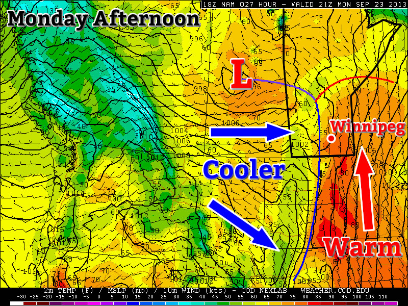
Today will be a warm day by late September standards. High temperatures will be in the low twenties in the Red River Valley. A bit further east in south-eastern Manitoba some areas may approach the mid twenties. But a bit further west in western Manitoba, temperatures will struggle to reach the upper teens. The discrepancy in temperatures over Southern Manitoba today is resulting from a cold front located over western Manitoba. In the vicinity of this front there is extensive cloud cover and some rain activity. Further east, skies are clearer, allowing for the atmosphere to heat up a bit more. Some of the rain showers over western Manitoba may sneak into the Red River Valley later today (as cloudiness increases later today), but little in the way of accumulating rain is expected. Over western Manitoba the rain will probably amount to between 5 and 15mm in general.

Tuesday

Tuesday

Mainly Sunny
21°C / 7°C

Surprisingly, Tuesday will be quite a nice day despite the passage of a cold front on Monday night. High temperatures on Tuesday will be in the upper teens or lower twenties in Southern Manitoba, under sunny skies and light westerly winds.

Wednesday

Wednesday

Mainly Cloudy
22°C / 14°C

Wednesday will see cloudier conditions return ahead of a developing weather system. Temperatures on Wednesday are expected to max out in the low twenties in Southern Manitoba and the wind will be gusty and from the south-east. Some rain may occur over Western Manitoba on Wednesday, but it’s too early to speculate on the location or intensity of it.

Long Range

The long range outlook will be dominated initially be the weather system mentioned in Wednesday’s forecast. This low pressure system is currently expected to track through Manitoba, with its main impacts likely to be confined to the Western half of the province. However, it is possible that this system may change track, so it could potentially affect other parts of Manitoba as well – more details on that will be available in Wednesday’s post.

Once that weather system passes by, conditions should return to near seasonal values for the end of the week. Next weekend is looking fairly pleasant, with near to slightly above seasonably temperatures…but of course that could change before the weekend actually arrives!

Elsewhere in Weather News: September 14th, 2013

Historical Flooding in Colorado

This past week Colorado has been absolutely swamped thanks to moisture streaming up from the Gulf of Mexico, riding up the Rocky Mountains (upslope flow) and then falling as rain. High pressure sliding down from the north in the US Plains as well as an upper-level low to the west drew in the moist air from the southeast. Generally, 850mb dewpoints could be found in the 15°C range and PWAT values around 40mm in Eastern Colorado. Plentiful moisture was in place – a recipe for heavy rains that had the possibility to fall for a long period of time. This became the case for Wednesday evening through Friday morning for Boulder, Colorado and surrounding communities.

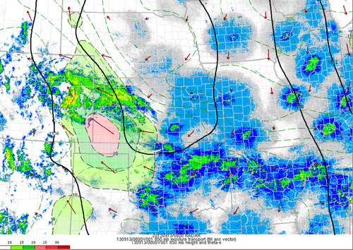
850mb moisture transport

Radar with overlay of the 850 moisture transport, notice the vectors all pointing towards the Rockies. Taken Friday 3am. (Source: SPC Mesoanalysis image archive)

As best described by NWS Boulder, flooding of “biblical” proportions took place is continues as of Friday night. Small creeks easily turned into raging rivers that inundated whole towns and mudslides blocked highways, took out buildings. The death toll is already at four but concerns of more as 172 people are still missing and some communities are literally cut off, with no roads leading in or out of town. Interstate 25 had been closed due to water running over it as well as numerous other highways that had simply been washed away.

The average rainfall per year for Boulder, CO is around 525mm, this means that in a few days Boulder got over half its annual rainfall at 310mm. This easily beats out the old record for rainfall in September (243mm), and average of 43mm (this month; 721% above average September rainfall). Interestingly enough, the area which received all this rainfall was under a moderate to extreme drought as per the Drought Index.

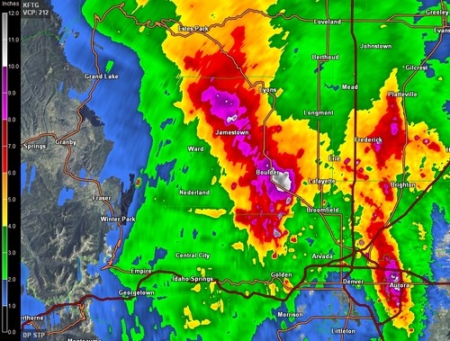
Rainfall estimates

Estimated rainfall from KFTG as of Friday 3am. Notice the dark purples/white; areas above 200mm estimates. Map storm total accumulation. (Source: GRLevel3)

It appears as though Boulder might get a break from the rain today as the upper-level low weakens and moves further east though there is still a slight chance for pop-up (non-severe) storms. Tomorrow will likely bring with it more rain for the region, unfortunately.